


NHC Offshore Waters Forecasts
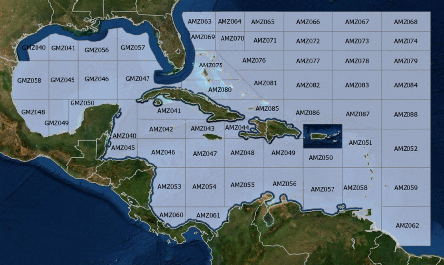
Hover to view popup zone forecast; click a zone to view related text forecast below. Show All Text Below
Southwest Tropical North Atlantic & Caribbean Sea (OFFNT3)
000
FZNT23 KNHC 030258
OFFNT3

Offshore Waters Forecast for the Caribbean Sea and Tropical
N Atlantic
NWS National Hurricane Center Miami, FL
1058 PM EDT Thu May 2 2024

Offshore Waters Forecast for Caribbean Sea, and the Tropical N
Atlantic from 07N to 19N W of 55W.

Seas given as significant wave height, which is the average
height of the highest 1/3 of the waves. Individual waves may be
more than twice the significant wave height.
Synopsis for the Caribbean Sea & Tropical North Atlantic
AMZ001-031500-
Synopsis for Caribbean Sea, and Tropical N Atlantic from 07N to
19N W of 55W
1058 PM EDT Thu May 2 2024

.SYNOPSIS...High pressure centered N of the region is supporting
moderate to fresh trade winds over the central and eastern
Caribbean. These winds will gradually subside into the weekend as
the pressure gradient relaxes. Moderate to fresh northeast winds
are expected in the lee of Cuba, northwestern Caribbean, and just
in the Windward Passage into Fri night and in the Windward
Passage Sat night and Sun night. Gentle to moderate trade winds
are expected over the area through the forecast period, except for
mostly fresh winds in the south-central Caribbean. The
interaction between a trough along 80W/81W south of 20N with the
base of a western Atlantic upper-level trough that extends into
the western Caribbean has resulted in the development of scattered
showers and thunderstorms from the eastern tip of Cuba to the
Windward Passage.
AMZ040 Zone Forecast
AMZ040-031500-
Caribbean N of 18N W of 85W including Yucatan Basin-
1058 PM EDT Thu May 2 2024

.OVERNIGHT...E winds 10 to 15 kt. Seas 3 ft or less.
.FRI...E winds 10 to 15 kt. Seas 2 to 4 ft.
.FRI NIGHT...E winds 10 to 15 kt. Seas 2 to 4 ft.
.SAT...E winds 10 to 15 kt. Seas 3 to 5 ft.
.SAT NIGHT...E winds 10 to 15 kt. Seas 2 to 4 ft.
.SUN...E to SE winds 10 to 15 kt. Seas 3 to 5 ft.
.SUN NIGHT...E winds 10 to 15 kt. Seas 2 to 4 ft.
.MON...E to SE winds 10 to 15 kt. Seas 2 to 4 ft.
.MON NIGHT...E winds 10 to 15 kt. Seas 2 to 4 ft.
.TUE...E to SE winds 10 to 15 kt. Seas 2 to 4 ft.
.TUE NIGHT...E to SE winds 10 to 15 kt. Seas 2 to 4 ft.
Forecaster Konarik
AMZ041 Zone Forecast
AMZ041-031500-
Caribbean N of 20N E of 85W-
1058 PM EDT Thu May 2 2024

.OVERNIGHT...NE to E winds 10 to 15 kt W of 81W, and NE to E
15 kt E of 81W. Seas 2 to 4 ft.
.FRI...E winds 10 to 15 kt. Seas 2 to 4 ft.
.FRI NIGHT...E winds 10 to 15 kt W of 81W, and NE to E 15 to
20 kt E of 81W. Seas 3 to 5 ft.
.SAT...E winds 10 to 15 kt. Seas 3 to 5 ft.
.SAT NIGHT...E winds 10 to 15 kt. Seas 2 to 4 ft.
.SUN...E winds 10 to 15 kt. Seas 2 to 4 ft.
.SUN NIGHT...E winds 10 to 15 kt. Seas 2 to 4 ft.
.MON...E winds 10 to 15 kt. Seas 2 to 4 ft.
.MON NIGHT...E winds 10 kt. Seas 3 ft or less.
.TUE...E to SE winds 10 to 15 kt. Seas 3 ft or less.
.TUE NIGHT...E winds 10 kt. Seas 3 ft or less.
Forecaster Konarik
AMZ042 Zone Forecast
AMZ042-031500-
Caribbean from 18N to 20N between 80W and 85W including Cayman
Basin-
1058 PM EDT Thu May 2 2024

.OVERNIGHT...NE to E winds 10 to 15 kt. Seas 3 ft or less.
.FRI...NE to E winds 10 to 15 kt. Seas 2 to 4 ft.
.FRI NIGHT...NE to E winds 10 to 15 kt. Seas 2 to 4 ft.
.SAT...E winds 10 to 15 kt. Seas 2 to 4 ft.
.SAT NIGHT...E winds 10 to 15 kt. Seas 2 to 4 ft.
.SUN...E winds 10 to 15 kt. Seas 2 to 4 ft.
.SUN NIGHT...E winds 10 to 15 kt. Seas 2 to 4 ft.
.MON...E winds 10 to 15 kt. Seas 3 ft or less.
.MON NIGHT...E winds 10 kt. Seas 3 ft or less.
.TUE...E to SE winds 10 kt. Seas 3 ft or less.
.TUE NIGHT...E winds 10 to 15 kt. Seas 3 ft or less.
Forecaster Konarik
AMZ043 Zone Forecast
AMZ043-031500-
Caribbean from 18N to 20N between 76W and 80W-
1058 PM EDT Thu May 2 2024

.OVERNIGHT...NE to E winds 10 to 15 kt. Seas 2 to 4 ft.
.FRI...E winds 10 to 15 kt. Seas 2 to 4 ft. Scattered showers.
.FRI NIGHT...NE to E winds 10 to 15 kt. Seas 3 to 5 ft.
.SAT...NE to E winds 10 to 15 kt. Seas 3 to 5 ft.
.SAT NIGHT...E winds 10 to 15 kt. Seas 3 to 5 ft.
.SUN...E winds 10 to 15 kt. Seas 2 to 4 ft.
.SUN NIGHT...E winds 10 to 15 kt. Seas 2 to 4 ft.
.MON...E winds 10 to 15 kt. Seas 2 to 4 ft.
.MON NIGHT...E winds 10 kt. Seas 2 to 4 ft.
.TUE...E winds 10 kt. Seas 3 ft or less.
.TUE NIGHT...E winds 10 kt. Seas 3 ft or less.
Forecaster Konarik
AMZ044 Zone Forecast
AMZ044-031500-
Caribbean approaches to the Windward Passage-
1058 PM EDT Thu May 2 2024

.OVERNIGHT...In the Gulf of Gonave, N to NE winds 10 to 15 kt in
the late evening and early morning, becoming variable less than
5 kt. Elsewhere, NE winds 15 to 20 kt. Seas 2 to 4 ft. Scattered
showers.
.FRI...In the Gulf of Gonave, variable winds less than 5 kt,
becoming N 10 kt early in the evening. Elsewhere, NE to E winds
10 to 15 kt. Seas 2 to 4 ft.
.FRI NIGHT...NE to E winds 10 kt in the Gulf of Gonave, and NE to
E 15 to 20 kt elsewhere. Seas 3 to 5 ft. Scattered showers.
.SAT...Variable winds less than 5 kt in the Gulf of Gonave, and
NE to E 10 to 15 kt elsewhere. Seas 3 to 5 ft.
.SAT NIGHT...In the Gulf of Gonave, E winds 10 kt. Seas 3 ft or
less. Elsewhere, NE to E winds 15 to 20 kt. Seas 3 to 5 ft.
.SUN...Variable winds less than 5 kt in the Gulf of Gonave, and E
10 to 15 kt elsewhere. Seas 2 to 4 ft.
.SUN NIGHT...Variable winds less than 5 kt in the Gulf of Gonave,
and NE to E 10 to 15 kt elsewhere. Seas 2 to 4 ft.
.MON...Variable winds less than 5 kt in the Gulf of Gonave, and
NE to E 10 kt elsewhere. Seas 2 to 4 ft.
.MON NIGHT...Variable winds less than 5 kt in the Gulf of Gonave,
and NE to E 10 to 15 kt elsewhere. Seas 2 to 4 ft.
.TUE...Variable winds less than 5 kt in the Gulf of Gonave, and
NE to E 10 kt elsewhere. Seas 3 ft or less.
.TUE NIGHT...Variable winds less than 5 kt in the Gulf of Gonave,
and NE to E 10 to 15 kt elsewhere. Seas 3 ft or less.
Forecaster Konarik
AMZ045 Zone Forecast
AMZ045-031500-
S of 18N W of 85W including Gulf of Honduras-
1058 PM EDT Thu May 2 2024

.OVERNIGHT...E winds 10 to 15 kt. Seas 3 ft or less.
.FRI...E winds 10 to 15 kt. Seas 3 ft or less.
.FRI NIGHT...E winds 10 to 15 kt. Seas 3 ft or less.
.SAT...E winds 10 to 15 kt. Seas 3 ft or less.
.SAT NIGHT...E winds 10 to 15 kt. Seas 2 to 4 ft.
.SUN...E winds 10 to 15 kt. Seas 2 to 4 ft.
.SUN NIGHT...E winds 15 kt. Seas 2 to 4 ft.
.MON...E winds 10 to 15 kt. Seas 2 to 4 ft.
.MON NIGHT...E winds 15 kt. Seas 2 to 4 ft.
.TUE...E winds 10 to 15 kt. Seas 2 to 4 ft.
.TUE NIGHT...E winds 15 to 20 kt. Seas 2 to 4 ft.
Forecaster Konarik
AMZ046 Zone Forecast
AMZ046-031500-
Caribbean from 15N to 18N between 80W and 85W-
1058 PM EDT Thu May 2 2024

.OVERNIGHT...NE winds 10 kt. Seas 3 ft or less.
.FRI...NE to E winds 10 kt. Seas 3 ft or less.
.FRI NIGHT...NE to E winds 10 to 15 kt. Seas 3 ft or less.
.SAT...E winds 10 kt. Seas 3 ft or less.
.SAT NIGHT...E winds 10 to 15 kt. Seas 3 ft or less.
.SUN...E winds 10 kt. Seas 3 ft or less.
.SUN NIGHT...E winds 10 to 15 kt. Seas 2 to 4 ft W of 82W, and
3 ft or less E of 82W.
.MON...E winds 10 kt. Seas 3 ft or less.
.MON NIGHT...E winds 10 to 15 kt. Seas 3 ft or less.
.TUE...E to SE winds 10 kt. Seas 3 ft or less.
.TUE NIGHT...E winds 10 to 15 kt. Seas 2 to 4 ft W of 82W, and
3 ft or less E of 82W.
Forecaster Konarik
AMZ047 Zone Forecast
AMZ047-031500-
Caribbean from 15N to 18N between 76W and 80W-
1058 PM EDT Thu May 2 2024

.OVERNIGHT...S of 17N, variable winds less than 5 kt, becoming NE
to E 10 kt early in the morning. N of 17N, NE to E winds 10 kt.
Seas 2 to 4 ft.
.FRI...E winds 10 kt. Seas 3 ft or less.
.FRI NIGHT...NE to E winds 10 kt. Seas 2 to 4 ft.
.SAT...E winds 10 to 15 kt. Seas 2 to 4 ft.
.SAT NIGHT...E winds 10 to 15 kt. Seas 2 to 4 ft.
.SUN...E winds 10 to 15 kt. Seas 2 to 4 ft.
.SUN NIGHT...E winds 10 to 15 kt. Seas 2 to 4 ft.
.MON...E winds 10 to 15 kt. Seas 2 to 4 ft.
.MON NIGHT...E winds 10 to 15 kt. Seas 2 to 4 ft.
.TUE...E winds 10 to 15 kt. Seas 2 to 4 ft.
.TUE NIGHT...E winds 10 to 15 kt. Seas 2 to 4 ft.
Forecaster Konarik
AMZ048 Zone Forecast
AMZ048-031500-
Caribbean from 15N to 18N between 72W and 76W-
1058 PM EDT Thu May 2 2024

.OVERNIGHT...NE to E winds 10 kt. Seas 3 to 5 ft. Scattered
showers.
.FRI...E winds 10 kt. Seas 2 to 4 ft.
.FRI NIGHT...NE to E winds 10 to 15 kt. Seas 2 to 4 ft.
.SAT...E winds 10 to 15 kt. Seas 3 to 5 ft. Scattered showers.
.SAT NIGHT...E winds 10 to 15 kt. Seas 3 to 5 ft.
.SUN...E winds 10 to 15 kt. Seas 3 to 5 ft.
.SUN NIGHT...E winds 10 to 15 kt. Seas 3 to 5 ft.
.MON...E winds 10 to 15 kt. Seas 4 to 6 ft.
.MON NIGHT...E winds 10 to 15 kt. Seas 3 to 5 ft.
.TUE...E winds 10 to 15 kt. Seas 3 to 5 ft.
.TUE NIGHT...E winds 10 to 15 kt. Seas 3 to 5 ft.
Forecaster Konarik
AMZ049 Zone Forecast
AMZ049-031500-
Caribbean N of 15N between 68W and 72W-
1058 PM EDT Thu May 2 2024

.OVERNIGHT...E winds 10 kt. Seas 3 to 5 ft. Scattered showers.
.FRI...E winds 10 kt. Seas 3 to 5 ft. Scattered showers.
.FRI NIGHT...NE to E winds 10 to 15 kt. Seas 2 to 4 ft. Scattered
showers.
.SAT...E winds 10 to 15 kt. Seas 3 to 5 ft.
.SAT NIGHT...NE to E winds 10 to 15 kt. Seas 3 to 5 ft.
.SUN...E winds 15 kt. Seas 3 to 5 ft.
.SUN NIGHT...E winds 10 to 15 kt. Seas 3 to 5 ft.
.MON...E winds 10 to 15 kt. Seas 4 to 6 ft.
.MON NIGHT...NE to E winds 10 to 15 kt. Seas 3 to 5 ft.
.TUE...E winds 10 to 15 kt. Seas 3 to 5 ft.
.TUE NIGHT...NE to E winds 10 to 15 kt. Seas 3 to 5 ft.
Forecaster Konarik
AMZ050 Zone Forecast
AMZ050-031500-
Caribbean N of 15N between 64W and 68W-
1058 PM EDT Thu May 2 2024

.OVERNIGHT...E to SE winds 10 to 15 kt. Seas 3 to 5 ft.
.FRI...SE winds 10 to 15 kt. Seas 3 to 5 ft. Scattered showers
and isolated tstms.
.FRI NIGHT...E winds 10 kt. Seas 3 to 5 ft. Scattered showers.
.SAT...E winds 10 to 15 kt. Seas 3 to 5 ft.
.SAT NIGHT...E winds 10 to 15 kt. Seas 3 to 5 ft.
.SUN...E winds 15 kt W of 66W, and E 10 to 15 kt E of 66W. Seas
3 to 5 ft.
.SUN NIGHT...E winds 10 to 15 kt. Seas 3 to 5 ft.
.MON...E winds 10 to 15 kt. Seas 2 to 4 ft.
.MON NIGHT...E winds 10 to 15 kt. Seas 2 to 4 ft.
.TUE...E winds 10 kt. Seas 2 to 4 ft.
.TUE NIGHT...E winds 10 kt. Seas 2 to 4 ft.
Forecaster Konarik
AMZ051 Zone Forecast
AMZ051-031500-
Offshore Waters Leeward Islands-
1058 PM EDT Thu May 2 2024

.OVERNIGHT...E to SE winds 10 to 15 kt. Seas 4 to 6 ft. Scattered
showers.
.FRI...SE winds 10 to 15 kt. Seas 4 to 6 ft. Scattered showers.
.FRI NIGHT...E to SE winds 10 kt. Seas 3 to 5 ft. Scattered
showers.
.SAT...E to SE winds 10 kt. Seas 3 to 5 ft.
.SAT NIGHT...E winds 10 kt. Seas 3 to 5 ft.
.SUN...E winds 10 kt. Seas 3 to 5 ft.
.SUN NIGHT...NE to E winds 10 kt. Seas 3 to 5 ft.
.MON...NE to E winds 10 kt. Seas 3 to 5 ft.
.MON NIGHT...NE to E winds 10 to 15 kt. Seas 3 to 5 ft.
.TUE...E winds 10 kt. Seas 3 to 5 ft.
.TUE NIGHT...E winds 10 kt. Seas 4 to 6 ft in N to NE swell.
Forecaster Konarik
AMZ052 Zone Forecast
AMZ052-031500-
Tropical N Atlantic from 15N to 19N between 55W and 60W-
1058 PM EDT Thu May 2 2024

.OVERNIGHT...E to SE winds 15 kt. Seas 4 to 6 ft.
.FRI...SE winds 10 to 15 kt. Seas 4 to 6 ft.
.FRI NIGHT...SE winds 10 to 15 kt. Seas 4 to 6 ft. Scattered
showers.
.SAT...SE to S winds 10 kt. Seas 4 to 6 ft in N swell.
.SAT NIGHT...S of 17N, E to SE winds 10 kt. N of 17N, variable
winds less than 5 kt, becoming E to SE 10 kt early in the
morning. Seas 3 to 5 ft.
.SUN...S of 17N, E to SE winds 10 kt. N of 17N, SE winds 10 kt in
the late morning and early afternoon, becoming variable less than
5 kt. Seas 3 to 5 ft.
.SUN NIGHT...S of 17N, NE to E winds 10 kt. N of 17N, variable
winds less than 5 kt, becoming NE 10 kt early in the morning.
Seas 3 to 5 ft.
.MON...NE to E winds 10 kt. Seas 3 to 5 ft.
.MON NIGHT...NE to E winds 10 to 15 kt. Seas 3 to 5 ft.
.TUE...NE to E winds 10 to 15 kt. Seas 4 to 6 ft.
.TUE NIGHT...E winds 10 kt. Seas 4 to 6 ft in N to NE swell.
Forecaster Konarik
AMZ053 Zone Forecast
AMZ053-031500-
W Central Caribbean from 11N to 15N W of 80W-
1058 PM EDT Thu May 2 2024

.OVERNIGHT...N to NE winds 10 kt in the late evening and early
morning, becoming variable less than 5 kt. Seas 3 ft or less.
.FRI...In the reefs, variable winds less than 5 kt, becoming NE
10 kt early in the evening. In the open waters, variable winds
less than 5 kt. Seas 3 ft or less.
.FRI NIGHT...NE to E winds 10 kt. Seas 3 ft or less.
.SAT...In the reefs, variable winds less than 5 kt, becoming NE
to E 10 kt early in the evening. In the open waters, variable
winds less than 5 kt. Seas 3 ft or less.
.SAT NIGHT...NE to E winds 10 kt. Seas 3 ft or less.
.SUN...E winds 10 kt. Seas 3 ft or less.
.SUN NIGHT...NE to E winds 10 kt. Seas 3 ft or less.
.MON...In the reefs, E winds 10 kt in the late morning and early
afternoon, becoming variable less than 5 kt. In the open waters,
NE to E winds 10 kt. Seas 3 ft or less.
.MON NIGHT...NE to E winds 10 kt. Seas 3 ft or less.
.TUE...NE to E winds 10 kt. Seas 3 ft or less.
.TUE NIGHT...NE to E winds 10 kt. Seas 3 ft or less.
Forecaster Konarik
AMZ054 Zone Forecast
AMZ054-031500-
Caribbean from 11N to 15N between 76W and 80W-
1058 PM EDT Thu May 2 2024

.OVERNIGHT...N to NE winds 10 kt. Seas 2 to 4 ft.
.FRI...W of 78W, NE winds 10 kt in the late morning and early
afternoon, becoming variable less than 5 kt. E of 78W, NE winds
10 kt. Seas 3 ft or less.
.FRI NIGHT...W of 78W, NE winds 10 kt in the late evening and
early morning, becoming variable less than 5 kt. E of 78W, NE
winds 10 kt. Seas 3 ft or less.
.SAT...NE winds 10 kt. Seas 3 ft or less.
.SAT NIGHT...NE to E winds 10 kt. Seas 3 ft or less.
.SUN...NE to E winds 10 kt. Seas 3 ft or less.
.SUN NIGHT...NE to E winds 10 to 15 kt. Seas 2 to 4 ft.
.MON...NE to E winds 10 to 15 kt. Seas 2 to 4 ft.
.MON NIGHT...NE to E winds 10 to 15 kt. Seas 3 to 5 ft.
.TUE...NE to E winds 10 to 15 kt. Seas 3 to 5 ft.
.TUE NIGHT...NE to E winds 10 to 15 kt. Seas 2 to 4 ft.
Forecaster Konarik
AMZ055 Zone Forecast
AMZ055-031500-
Caribbean from 11N to 15N between 72W and 76W including Colombia
Basin-
1058 PM EDT Thu May 2 2024

.OVERNIGHT...NE to E winds 10 to 15 kt. Seas 3 to 5 ft.
.FRI...NE to E winds 10 kt. Seas 2 to 4 ft.
.FRI NIGHT...S of 13N, NE winds 10 kt in the late evening and
early morning, becoming variable less than 5 kt. N of 13N, NE to
E winds 10 kt. Seas 2 to 4 ft.
.SAT...NE to E winds 10 kt. Seas 2 to 4 ft. Scattered showers.
.SAT NIGHT...E winds 10 to 15 kt. Seas 2 to 4 ft.
.SUN...E winds 10 to 15 kt. Seas 3 to 5 ft.
.SUN NIGHT...NE to E winds 10 to 15 kt S of 13N, and E 15 to
20 kt N of 13N. Seas 3 to 5 ft.
.MON...NE to E winds 10 to 15 kt S of 13N, and E 15 to 20 kt N of
13N. Seas 4 to 6 ft.
.MON NIGHT...NE to E winds 15 to 20 kt S of 13N, and E 15 to
20 kt N of 13N. Seas 3 to 5 ft.
.TUE...E winds 10 to 15 kt. Seas 3 to 5 ft.
.TUE NIGHT...NE to E winds 10 to 15 kt. Seas 3 to 5 ft.
Forecaster Konarik
AMZ056 Zone Forecast
AMZ056-031500-
Caribbean S of 15N between 68W and 72W including Gulf of
Venezuela-
1058 PM EDT Thu May 2 2024

.OVERNIGHT...E winds 10 to 15 kt. Seas 3 to 5 ft. Scattered
showers.
.FRI...E winds 10 to 15 kt. Seas 3 to 5 ft. Scattered tstms.
.FRI NIGHT...E winds 10 to 15 kt. Seas 3 to 5 ft.
.SAT...E winds 10 to 15 kt. Seas 3 to 5 ft.
.SAT NIGHT...E winds 10 to 15 kt. Seas 3 to 5 ft.
.SUN...E winds 15 kt. Seas 3 to 5 ft.
.SUN NIGHT...E winds 15 to 20 kt. Seas 4 to 6 ft.
.MON...E winds 15 to 20 kt. Seas 4 to 6 ft.
.MON NIGHT...E winds 15 to 20 kt. Seas 3 to 5 ft.
.TUE...E winds 15 kt. Seas 3 to 5 ft.
.TUE NIGHT...E winds 15 kt. Seas 3 to 5 ft.
Forecaster Konarik
AMZ057 Zone Forecast
AMZ057-031500-
Caribbean S of 15N between 64W and 68W including Venezuela Basin-
1058 PM EDT Thu May 2 2024

.OVERNIGHT...E winds 15 to 20 kt. Seas 4 to 6 ft.
.FRI...E to SE winds 15 to 20 kt. Seas 4 to 6 ft. Scattered
showers.
.FRI NIGHT...E winds 15 to 20 kt. Seas 3 to 5 ft.
.SAT...E winds 10 to 15 kt. Seas 3 to 5 ft.
.SAT NIGHT...E winds 15 to 20 kt. Seas 3 to 5 ft.
.SUN...E winds 10 to 15 kt. Seas 4 to 6 ft.
.SUN NIGHT...E winds 15 kt. Seas 3 to 5 ft.
.MON...E winds 10 to 15 kt. Seas 3 to 5 ft.
.MON NIGHT...E winds 15 kt. Seas 3 to 5 ft.
.TUE...E winds 10 to 15 kt. Seas 3 to 5 ft.
.TUE NIGHT...E winds 15 to 20 kt. Seas 3 to 5 ft.
Forecaster Konarik
AMZ058 Zone Forecast
AMZ058-031500-
Offshore Waters Windward Islands including Trinidad and Tobago-
1058 PM EDT Thu May 2 2024

.OVERNIGHT...E to SE winds 15 to 20 kt in the Caribbean, and E to
SE 10 to 15 kt in the Atlc. Seas 4 to 6 ft.
.FRI...E to SE winds 15 to 20 kt in the Caribbean, and E to SE
10 to 15 kt in the Atlc. Seas 4 to 6 ft.
.FRI NIGHT...E to SE winds 15 to 20 kt in the Caribbean, and E to
SE 10 to 15 kt in the Atlc. Seas 4 to 6 ft.
.SAT...E to SE winds 10 to 15 kt. Seas 4 to 6 ft.
.SAT NIGHT...E winds 15 to 20 kt in the Caribbean, and E 10 to
15 kt in the Atlc. Seas 4 to 6 ft.
.SUN...E winds 10 to 15 kt. Seas 4 to 6 ft.
.SUN NIGHT...E winds 10 to 15 kt. Seas 4 to 6 ft.
.MON...E winds 10 to 15 kt. Seas 4 to 6 ft.
.MON NIGHT...E winds 10 to 15 kt. Seas 4 to 6 ft.
.TUE...E winds 10 to 15 kt. Seas 4 to 6 ft.
.TUE NIGHT...E winds 10 to 15 kt. Seas 3 to 5 ft.
Forecaster Konarik
AMZ059 Zone Forecast
AMZ059-031500-
Tropical N Atlantic from 11N and 15N between 55W and 60W-
1058 PM EDT Thu May 2 2024

.OVERNIGHT...E winds 10 to 15 kt. Seas 4 to 6 ft.
.FRI...E to SE winds 10 to 15 kt. Seas 4 to 6 ft.
.FRI NIGHT...E to SE winds 15 kt. Seas 5 to 7 ft in E swell.
.SAT...E to SE winds 10 to 15 kt. Seas 5 to 7 ft in E to SE
swell.
.SAT NIGHT...E winds 10 to 15 kt. Seas 5 to 7 ft in E to SE
swell.
.SUN...E winds 10 to 15 kt. Seas 5 to 7 ft in E to SE swell.
.SUN NIGHT...NE to E winds 10 to 15 kt. Seas 5 to 7 ft in E to SE
swell.
.MON...E winds 10 to 15 kt. Seas 4 to 6 ft.
.MON NIGHT...E winds 10 to 15 kt. Seas 4 to 6 ft.
.TUE...E winds 10 to 15 kt. Seas 4 to 6 ft.
.TUE NIGHT...E winds 10 to 15 kt. Seas 3 to 5 ft.
Forecaster Konarik
AMZ060 Zone Forecast
AMZ060-031500-
SW Caribbean S of 11N W of 80W-
1058 PM EDT Thu May 2 2024

.OVERNIGHT...Variable winds less than 5 kt. Seas 3 ft or less in
NE swell.
.FRI...Variable winds less than 5 kt. Seas 3 ft or less.
.FRI NIGHT...S of 10N, variable winds less than 5 kt in the late
evening and early morning. Variable winds less than 5 kt early in
the morning. N of 10N, NE to E winds 10 kt in the late evening
and early morning. Seas 3 ft or less.
.SAT...Variable winds less than 5 kt, becoming N to NE 10 kt
early in the evening. Seas 3 ft or less.
.SAT NIGHT...Variable winds less than 5 kt. Seas 3 ft or less.
.SUN...Variable winds less than 5 kt. Seas 3 ft or less.
.SUN NIGHT...S of 10N, N winds 10 kt in the late evening and
early morning, becoming variable less than 5 kt. N of 10N,
variable winds less than 5 kt. Seas 3 ft or less.
.MON...Variable winds less than 5 kt. Seas 3 ft or less.
.MON NIGHT...Variable winds less than 5 kt. Seas 3 ft or less.
.TUE...Variable winds less than 5 kt. Seas 3 ft or less.
.TUE NIGHT...Variable winds less than 5 kt. Seas 3 ft or less.
Forecaster Konarik
AMZ061 Zone Forecast
AMZ061-031500-
SW Caribbean S of 11N E of 80W including the approaches to the
Panama Canal-
1058 PM EDT Thu May 2 2024

.OVERNIGHT...NW to N winds 10 kt. Seas 3 ft or less. Scattered
showers.
.FRI...S of 10N, NW winds 10 kt. N of 10N, variable winds less
than 5 kt, becoming NW to N 10 kt early in the evening. Seas 3 ft
or less.
.FRI NIGHT...NW to N winds 10 kt in the late evening and early
morning, becoming variable less than 5 kt. Seas 3 ft or less.
.SAT...Variable winds less than 5 kt, becoming NW to N 10 kt
early in the evening. Seas 3 ft or less.
.SAT NIGHT...N winds 10 kt in the late evening and early morning,
becoming variable less than 5 kt. Seas 3 ft or less.
.SUN...Variable winds less than 5 kt. Seas 3 ft or less.
.SUN NIGHT...S of 10N, N winds 10 kt in the late evening and
early morning, becoming variable less than 5 kt. N of 10N, N to
NE winds 10 kt. Seas 3 ft or less.
.MON...S of 10N, variable winds less than 5 kt, becoming NW to N
10 kt early in the evening. N of 10N, variable winds less than
5 kt. Seas 3 ft or less.
.MON NIGHT...N winds 10 kt in the late evening and early morning,
becoming variable less than 5 kt. Seas 3 ft or less.
.TUE...Variable winds less than 5 kt, becoming NW 10 kt early in
the evening. Seas 3 ft or less.
.TUE NIGHT...W to NW winds 10 kt S of 10N, and variable less than
5 kt N of 10N. Seas 3 ft or less.
Forecaster Konarik
AMZ062 Zone Forecast
AMZ062-031500-
Tropical N Atlantic from 7N and 11N between 55W and 60W-
1058 PM EDT Thu May 2 2024

.OVERNIGHT...E winds 15 to 20 kt. Seas 5 to 7 ft.
.FRI...E winds 15 kt. Seas 5 to 7 ft in E swell.
.FRI NIGHT...E winds 15 kt. Seas 5 to 7 ft in E swell.
.SAT...E winds 15 kt. Seas 5 to 7 ft in E swell.
.SAT NIGHT...E winds 15 kt. Seas 5 to 7 ft in E swell.
.SUN...E winds 10 to 15 kt. Seas 5 to 7 ft in E swell.
.SUN NIGHT...NE to E winds 15 kt. Seas 5 to 7 ft in E swell.
.MON...NE to E winds 10 to 15 kt. Seas 5 to 7 ft in E swell.
.MON NIGHT...NE to E winds 15 kt. Seas 4 to 6 ft.
.TUE...E winds 10 to 15 kt. Seas 4 to 6 ft.
.TUE NIGHT...E winds 15 kt. Seas 4 to 6 ft.
Forecaster Konarik
Southwest North Atlantic (OFFNT5)
000
FZNT25 KNHC 030307
OFFNT5

Offshore Waters Forecast for the SW N Atlantic including the
Bahamas
NWS National Hurricane Center Miami, FL
1107 PM EDT Thu May 2 2024

Offshore Waters Forecast for the SW N Atlantic from 19N to 31N W
of 55W including Bahamas.

Seas given as significant wave height, which is the average
height of the highest 1/3 of the waves. Individual waves may be
more than twice the significant wave height.
Synopsis for the Southwest Atlantic
AMZ101-031515-
Synopsis for the SW N Atlantic including the Bahamas
1107 PM EDT Thu May 2 2024

.SYNOPSIS...The gradient between high pressure over the western
Atlantic and relatively lower pressure in the Caribbean Sea is
allowing for generally moderate to fresh east winds to be south
of about 25N, including the approaches to the Windward Passage.
A surface trough is expected to soon form north-northeast of
Hispaniola. The pressure gradient between the ridge and the
trough will support pulsing strong east to southeast east of the
trough, and moderate to fresh northeast to east winds west of
the trough. Presently, an upper trough is over the western
Atlantic. Numerous showers and thunderstorms are east of this
trough. The trough is expected to help promote the formation of
weak low pressure along the soon to form surface trough on Fri.
The low will track east-northeastward Fri through Sat, and
weaken back into a trough while exiting the area on Sun. High
pressure will then take precedence over the entire area early
next week. Moderate to fresh south winds are forecast to develop
over the waters east of northeastern Florida Tue and Tue night.
AMZ063 Zone Forecast
AMZ063-031515-
Atlantic from 29N to 31N W of 77W-
1107 PM EDT Thu May 2 2024

.OVERNIGHT...SE winds 10 kt. Seas 3 ft or less.
.FRI...E to SE winds 10 kt. Seas 3 ft or less.
.FRI NIGHT...E to SE winds 10 to 15 kt. Seas 3 ft or less.
.SAT...E to SE winds 10 kt. Seas 2 to 4 ft.
.SAT NIGHT...SE winds 15 kt. Seas 2 to 4 ft.
.SUN...SE winds 10 to 15 kt. Seas 2 to 4 ft.
.SUN NIGHT...SE to S winds 10 to 15 kt. Seas 2 to 4 ft.
.MON...SE to S winds 10 kt. Seas 2 to 4 ft.
.MON NIGHT...S winds 10 to 15 kt. Seas 2 to 4 ft.
.TUE...S to SW winds 10 kt. Seas 2 to 4 ft.
.TUE NIGHT...S winds 10 to 15 kt. Seas 3 to 5 ft.
Forecaster Konarik
AMZ064 Zone Forecast
AMZ064-031515-
Atlantic from 29N to 31N between 74W and 77W-
1107 PM EDT Thu May 2 2024

.OVERNIGHT...E winds 10 kt. Seas 3 ft or less.
.FRI...NE to E winds 10 kt. Seas 3 ft or less.
.FRI NIGHT...E winds 10 to 15 kt. Seas 2 to 4 ft.
.SAT...NE to E winds 10 kt. Seas 2 to 4 ft.
.SAT NIGHT...E to SE winds 10 to 15 kt. Seas 2 to 4 ft.
.SUN...E to SE winds 10 kt. Seas 3 to 5 ft.
.SUN NIGHT...SE winds 10 kt. Seas 3 to 5 ft.
.MON...SE winds 10 kt. Seas 2 to 4 ft.
.MON NIGHT...SE to S winds 10 kt. Seas 3 to 5 ft.
.TUE...S to SW winds 10 kt. Seas 3 to 5 ft.
.TUE NIGHT...S to SW winds 10 to 15 kt. Seas 2 to 4 ft.
Forecaster Konarik
AMZ065 Zone Forecast
AMZ065-031515-
Atlantic from 29N to 31N between 70W and 74W-
1107 PM EDT Thu May 2 2024

.OVERNIGHT...NE to E winds 10 kt. Seas 3 ft or less.
.FRI...NE winds 10 kt. Seas 3 ft or less.
.FRI NIGHT...NE winds 10 kt. Seas 3 ft or less.
.SAT...NE winds 10 to 15 kt. Seas 2 to 4 ft.
.SAT NIGHT...E winds 10 to 15 kt. Seas 3 to 5 ft.
.SUN...E winds 10 kt. Seas 3 to 5 ft.
.SUN NIGHT...E winds 10 kt. Seas 3 to 5 ft.
.MON...E winds 10 kt. Seas 3 to 5 ft.
.MON NIGHT...W of 72W, SE winds 10 kt. E of 72W, E to SE winds
10 kt in the late evening and early morning, becoming variable
less than 5 kt. Seas 3 to 5 ft.
.TUE...W of 72W, S to SW winds 10 kt. E of 72W, variable winds
less than 5 kt, becoming SW 10 kt early in the evening. Seas 3 to
5 ft.
.TUE NIGHT...S to SW winds 10 kt. Seas 3 to 5 ft.
Forecaster Konarik
AMZ066 Zone Forecast
AMZ066-031515-
Atlantic from 29N to 31N between 65W and 70W-
1107 PM EDT Thu May 2 2024

.OVERNIGHT...E winds 10 kt W of 67W, and variable less than 5 kt
E of 67W. Seas 3 ft or less.
.FRI...Variable winds less than 5 kt, becoming N 10 kt early in
the evening. Seas 3 ft or less.
.FRI NIGHT...NW to N winds 10 to 15 kt. Seas 2 to 4 ft.
.SAT...N to NE winds 10 to 15 kt. Seas 4 to 6 ft.
.SAT NIGHT...NE winds 10 to 15 kt. Seas 4 to 6 ft.
.SUN...NE winds 10 kt. Seas 4 to 6 ft in N to NE swell.
.SUN NIGHT...NE to E winds 10 kt. Seas 4 to 6 ft in N to NE
swell.
.MON...NE to E winds 10 kt. Seas 4 to 6 ft in NE swell.
.MON NIGHT...W of 67W, E to SE winds 10 kt in the late evening
and early morning, becoming variable less than 5 kt. E of 67W, E
to SE winds 10 kt. Seas 4 to 6 ft in NE swell.
.TUE...W of 67W, variable winds less than 5 kt. E of 67W, SE
winds 10 kt in the late morning and early afternoon, becoming
variable less than 5 kt. Seas 4 to 6 ft in NE swell.
.TUE NIGHT...W of 67W, variable winds less than 5 kt, becoming SW
10 kt early in the morning. E of 67W, S to SW winds 10 kt. Seas
4 to 6 ft in NE swell.
Forecaster Konarik
AMZ067 Zone Forecast
AMZ067-031515-
Atlantic from 29N to 31N between 60W and 65W-
1107 PM EDT Thu May 2 2024

.OVERNIGHT...Variable winds less than 5 kt. Seas 2 to 4 ft in N
to NE swell.
.FRI...Variable winds less than 5 kt, becoming NW 10 kt early in
the evening. Seas 3 ft or less.
.FRI NIGHT...NW winds 10 to 15 kt. Seas 2 to 4 ft.
.SAT...NW to N winds 10 to 15 kt. Seas 4 to 6 ft.
.SAT NIGHT...N to NE winds 10 to 15 kt. Seas 4 to 6 ft.
.SUN...N to NE winds 10 to 15 kt. Seas 4 to 6 ft.
.SUN NIGHT...NE winds 10 kt. Seas 4 to 6 ft in NE swell.
.MON...NE winds 10 kt. Seas 5 to 7 ft in N to NE swell.
.MON NIGHT...W of 62W, E winds 10 kt. E of 62W, NE to E winds
10 kt in the late evening and early morning, becoming variable
less than 5 kt. Seas 5 to 7 ft in NE swell.
.TUE...Variable winds less than 5 kt. Seas 5 to 7 ft in NE swell.
.TUE NIGHT...Variable winds less than 5 kt, becoming S to SW
10 kt early in the morning. Seas 4 to 6 ft in NE swell.
Forecaster Konarik
AMZ068 Zone Forecast
AMZ068-031515-
Atlantic from 29N to 31N between 55W and 60W-
1107 PM EDT Thu May 2 2024

.OVERNIGHT...W of 57W, variable winds less than 5 kt. E of 57W,
variable winds less than 5 kt, becoming S to SW 10 kt early in
the morning. Seas 3 to 5 ft in N swell.
.FRI...SW winds 10 kt. Seas 3 to 5 ft. Scattered showers.
.FRI NIGHT...W to NW winds 10 to 15 kt. Seas 3 to 5 ft.
.SAT...NW winds 10 kt. Seas 3 to 5 ft.
.SAT NIGHT...N winds 10 to 15 kt. Seas 4 to 6 ft.
.SUN...N winds 10 to 15 kt. Seas 5 to 7 ft in N to NE swell.
.SUN NIGHT...N winds 10 to 15 kt. Seas 6 to 8 ft in N to NE
swell.
.MON...N to NE winds 10 to 15 kt. Seas 6 to 9 ft in N to NE
swell.
.MON NIGHT...NE winds 10 to 15 kt. Seas 6 to 9 ft in N to NE
swell.
.TUE...NE winds 10 kt in the late morning and early afternoon,
becoming variable less than 5 kt. Seas 6 to 8 ft in N to NE
swell.
.TUE NIGHT...W of 57W, S to SW winds 10 kt early in the morning.
Variable winds less than 5 kt in the late evening and early
morning. E of 57W, variable less than 5 kt. Seas 5 to 7 ft in NE
swell.
Forecaster Konarik
AMZ069 Zone Forecast
AMZ069-031515-
Atlantic from 27N to 29N W of 77W-
1107 PM EDT Thu May 2 2024

.OVERNIGHT...E winds 10 kt. Seas 3 ft or less.
.FRI...E winds 10 to 15 kt. Seas 2 to 4 ft.
.FRI NIGHT...E winds 10 to 15 kt. Seas 2 to 4 ft.
.SAT...E winds 10 to 15 kt. Seas 2 to 4 ft.
.SAT NIGHT...E to SE winds 15 kt. Seas 3 to 5 ft.
.SUN...E to SE winds 10 to 15 kt. Seas 2 to 4 ft.
.SUN NIGHT...E to SE winds 10 to 15 kt. Seas 3 to 5 ft.
.MON...E to SE winds 10 to 15 kt. Seas 3 to 5 ft.
.MON NIGHT...SE winds 10 to 15 kt. Seas 2 to 4 ft.
.TUE...SE to S winds 10 kt. Seas 2 to 4 ft.
.TUE NIGHT...SE to S winds 10 to 15 kt. Seas 2 to 4 ft.
Forecaster Konarik
AMZ070 Zone Forecast
AMZ070-031515-
Atlantic from 27N to 29N between 74W and 77W-
1107 PM EDT Thu May 2 2024

.OVERNIGHT...NE to E winds 10 kt. Seas 2 to 4 ft.
.FRI...NE to E winds 10 kt. Seas 2 to 4 ft.
.FRI NIGHT...E winds 10 to 15 kt. Seas 3 to 5 ft.
.SAT...E winds 10 to 15 kt. Seas 3 to 5 ft.
.SAT NIGHT...E winds 10 to 15 kt. Seas 3 to 5 ft.
.SUN...E winds 10 to 15 kt. Seas 3 to 5 ft.
.SUN NIGHT...E to SE winds 10 to 15 kt. Seas 3 to 5 ft.
.MON...E to SE winds 10 kt. Seas 3 to 5 ft.
.MON NIGHT...E to SE winds 10 kt. Seas 3 to 5 ft.
.TUE...SE winds 10 kt. Seas 3 to 5 ft.
.TUE NIGHT...SE to S winds 10 kt. Seas 3 to 5 ft.
Forecaster Konarik
AMZ071 Zone Forecast
AMZ071-031515-
Atlantic from 27N to 29N between 70W and 74W-
1107 PM EDT Thu May 2 2024

.OVERNIGHT...E winds 10 kt. Seas 2 to 4 ft.
.FRI...NE to E winds 10 kt. Seas 2 to 4 ft.
.FRI NIGHT...NE to E winds 10 to 15 kt. Seas 3 to 5 ft.
.SAT...NE winds 10 to 15 kt. Seas 3 to 5 ft.
.SAT NIGHT...NE to E winds 10 to 15 kt. Seas 3 to 5 ft.
.SUN...NE to E winds 10 to 15 kt. Seas 3 to 5 ft.
.SUN NIGHT...E winds 10 to 15 kt. Seas 3 to 5 ft.
.MON...E winds 10 kt. Seas 3 to 5 ft.
.MON NIGHT...E to SE winds 10 kt. Seas 3 to 5 ft.
.TUE...E to SE winds 10 kt in the late morning and early
afternoon, becoming variable less than 5 kt. Seas 3 to 5 ft in NE
swell.
.TUE NIGHT...W of 72W, SE winds 10 kt. E of 72W, E to SE winds
10 kt in the late evening and early morning, becoming variable
less than 5 kt. Seas 3 to 5 ft in NE swell.
Forecaster Konarik
AMZ072 Zone Forecast
AMZ072-031515-
Atlantic from 27N to 29N between 65W and 70W-
1107 PM EDT Thu May 2 2024

.OVERNIGHT...E winds 10 kt. Seas 2 to 4 ft.
.FRI...NE winds 10 kt. Seas 2 to 4 ft.
.FRI NIGHT...N to NE winds 10 kt. Seas 2 to 4 ft.
.SAT...N to NE winds 10 to 15 kt. Seas 3 to 5 ft.
.SAT NIGHT...NE winds 10 to 15 kt. Seas 4 to 6 ft.
.SUN...NE winds 10 to 15 kt. Seas 4 to 6 ft.
.SUN NIGHT...NE to E winds 10 to 15 kt. Seas 4 to 6 ft.
.MON...NE to E winds 10 kt. Seas 4 to 6 ft in NE swell.
.MON NIGHT...E winds 10 kt. Seas 4 to 6 ft in NE swell.
.TUE...W of 67W, E winds 10 kt. E of 67W, E winds 10 kt in the
late morning and early afternoon, becoming variable less than
5 kt. Seas 4 to 6 ft in NE swell.
.TUE NIGHT...W of 67W, E winds 10 kt in the late evening and
early morning, becoming variable less than 5 kt. E of 67W,
variable winds less than 5 kt. Seas 4 to 6 ft in NE swell.
Forecaster Konarik
AMZ073 Zone Forecast
AMZ073-031515-
Atlantic from 27N to 29N between 60W and 65W-
1107 PM EDT Thu May 2 2024

.OVERNIGHT...E winds 10 kt. Seas 3 to 5 ft.
.FRI...NE winds 10 kt W of 62W, and variable less than 5 kt E of
62W. Seas 2 to 4 ft.
.FRI NIGHT...N winds 10 kt. Seas 2 to 4 ft.
.SAT...NW to N winds 10 kt. Seas 2 to 4 ft.
.SAT NIGHT...N winds 10 to 15 kt. Seas 4 to 6 ft.
.SUN...NE winds 10 to 15 kt. Seas 4 to 6 ft.
.SUN NIGHT...NE winds 10 to 15 kt. Seas 4 to 6 ft.
.MON...NE winds 10 kt. Seas 4 to 6 ft in N to NE swell.
.MON NIGHT...NE to E winds 10 kt. Seas 5 to 7 ft in N to NE
swell.
.TUE...W of 62W, E winds 10 kt. E of 62W, NE to E winds 10 kt in
the late morning and early afternoon, becoming variable less than
5 kt. Seas 5 to 7 ft in NE swell.
.TUE NIGHT...W of 62W, E to SE winds 10 kt in the late evening
and early morning, becoming variable less than 5 kt. E of 62W,
variable winds less than 5 kt. Seas 4 to 6 ft in NE swell.
Forecaster Konarik
AMZ074 Zone Forecast
AMZ074-031515-
Atlantic from 27N to 29N between 55W and 60W-
1107 PM EDT Thu May 2 2024

.OVERNIGHT...E to SE winds 10 kt. Seas 3 to 5 ft.
.FRI...W of 57W, SE to S winds 10 kt in the late morning and
early afternoon, becoming variable less than 5 kt. E of 57W, S
winds 10 kt. Seas 2 to 4 ft.
.FRI NIGHT...W of 57W, variable winds less than 5 kt, becoming NW
10 kt early in the morning. E of 57W, SW to W winds 10 kt. Seas
2 to 4 ft.
.SAT...NW winds 10 kt. Seas 2 to 4 ft.
.SAT NIGHT...NW to N winds 10 kt. Seas 3 to 5 ft.
.SUN...N winds 10 to 15 kt. Seas 4 to 6 ft.
.SUN NIGHT...N to NE winds 10 to 15 kt. Seas 4 to 6 ft.
.MON...N to NE winds 10 to 15 kt. Seas 5 to 7 ft in N to NE
swell.
.MON NIGHT...NE winds 10 kt. Seas 6 to 8 ft in N to NE swell.
.TUE...W of 57W, NE to E winds 10 kt in the late morning and
early afternoon, becoming variable less than 5 kt. E of 57W, NE
to E winds 10 kt. Seas 6 to 8 ft in N to NE swell.
.TUE NIGHT...Variable winds less than 5 kt W of 57W, and E 10 kt
E of 57W. Seas 5 to 7 ft in N to NE swell.
Forecaster Konarik
AMZ075 Zone Forecast
AMZ075-031515-
Northern Bahamas from 24N to 27N-
1107 PM EDT Thu May 2 2024

.OVERNIGHT...E winds 10 to 15 kt. Seas 3 to 5 ft.
.FRI...NE to E winds 10 to 15 kt. Seas 3 to 5 ft.
.FRI NIGHT...E winds 10 to 15 kt. Seas 3 to 5 ft.
.SAT...E winds 15 to 20 kt in the open Atlc waters, and E 10 to
15 kt elsewhere. Seas 4 to 6 ft.
.SAT NIGHT...E winds 15 kt. Seas 4 to 6 ft.
.SUN...E winds 10 to 15 kt. Seas 3 to 5 ft.
.SUN NIGHT...E winds 15 kt. Seas 3 to 5 ft.
.MON...E winds 10 to 15 kt. Seas 3 to 5 ft.
.MON NIGHT...E to SE winds 10 to 15 kt. Seas 3 to 5 ft.
.TUE...E winds 10 to 15 kt. Seas 3 to 5 ft.
.TUE NIGHT...E to SE winds 10 to 15 kt. Seas 3 to 5 ft.
Forecaster Konarik
AMZ076 Zone Forecast
AMZ076-031515-
Atlantic from 22N to 27N E of Bahamas to 70W-
1107 PM EDT Thu May 2 2024

.OVERNIGHT...NE to E winds 10 to 15 kt. Seas 3 to 5 ft.
.FRI...NE to E winds 10 to 15 kt. Seas 3 to 5 ft.
.FRI NIGHT...NE to E winds 10 to 15 kt. Seas 3 to 5 ft.
.SAT...NE to E winds 15 kt. Seas 4 to 6 ft.
.SAT NIGHT...E winds 10 to 15 kt. Seas 4 to 6 ft.
.SUN...E winds 10 to 15 kt. Seas 3 to 5 ft.
.SUN NIGHT...E winds 10 to 15 kt. Seas 3 to 5 ft.
.MON...E winds 10 to 15 kt. Seas 3 to 5 ft.
.MON NIGHT...E winds 10 to 15 kt. Seas 3 to 5 ft.
.TUE...E winds 10 kt. Seas 3 to 5 ft.
.TUE NIGHT...E winds 10 kt. Seas 3 to 5 ft.
Forecaster Konarik
AMZ077 Zone Forecast
AMZ077-031515-
Atlantic from 22N to 27N between 65W and 70W-
1107 PM EDT Thu May 2 2024

.OVERNIGHT...NE to E winds 10 to 15 kt. Seas 3 to 5 ft.
.FRI...NE to E winds 10 to 15 kt. Seas 3 to 5 ft.
.FRI NIGHT...NE winds 10 to 15 kt. Seas 3 to 5 ft.
.SAT...NE winds 10 to 15 kt. Seas 3 to 5 ft.
.SAT NIGHT...NE winds 10 to 15 kt. Seas 3 to 5 ft.
.SUN...NE winds 10 to 15 kt. Seas 3 to 5 ft.
.SUN NIGHT...NE to E winds 10 to 15 kt. Seas 4 to 6 ft.
.MON...NE to E winds 10 to 15 kt. Seas 4 to 6 ft.
.MON NIGHT...E winds 10 to 15 kt. Seas 4 to 6 ft.
.TUE...E winds 10 kt. Seas 4 to 6 ft in NE swell.
.TUE NIGHT...E winds 10 kt. Seas 4 to 6 ft in NE swell.
Forecaster Konarik
AMZ078 Zone Forecast
AMZ078-031515-
Atlantic from 25N to 27N between 60W and 65W-
1107 PM EDT Thu May 2 2024

.OVERNIGHT...E to SE winds 10 to 15 kt. Seas 4 to 6 ft. Scattered
showers.
.FRI...E winds 10 kt. Seas 3 to 5 ft.
.FRI NIGHT...NE winds 10 to 15 kt. Seas 2 to 4 ft.
.SAT...N to NE winds 10 to 15 kt. Seas 3 to 5 ft.
.SAT NIGHT...N winds 10 kt. Seas 2 to 4 ft.
.SUN...N to NE winds 10 to 15 kt. Seas 3 to 5 ft.
.SUN NIGHT...NE winds 10 to 15 kt. Seas 4 to 6 ft.
.MON...NE winds 10 to 15 kt. Seas 4 to 6 ft.
.MON NIGHT...NE to E winds 10 kt. Seas 4 to 6 ft in N to NE
swell.
.TUE...E winds 10 kt. Seas 4 to 6 ft in N to NE swell.
.TUE NIGHT...E winds 10 kt. Seas 4 to 6 ft in NE swell.
Forecaster Konarik
AMZ079 Zone Forecast
AMZ079-031515-
Atlantic from 25N to 27N between 55W and 60W-
1107 PM EDT Thu May 2 2024

.OVERNIGHT...E to SE winds 10 kt. Seas 4 to 6 ft in N swell.
Scattered showers.
.FRI...SE winds 10 kt in the late morning and early afternoon,
becoming variable less than 5 kt. Seas 3 to 5 ft in N swell.
Scattered showers.
.FRI NIGHT...Variable winds less than 5 kt. Seas 2 to 4 ft in N
swell.
.SAT...NW to N winds 10 kt. Seas 2 to 4 ft.
.SAT NIGHT...NW to N winds 10 kt. Seas 2 to 4 ft.
.SUN...N winds 10 kt. Seas 3 to 5 ft.
.SUN NIGHT...N to NE winds 10 to 15 kt. Seas 4 to 6 ft.
.MON...N to NE winds 10 kt. Seas 4 to 6 ft in N to NE swell.
.MON NIGHT...NE winds 10 kt. Seas 5 to 7 ft in N to NE swell.
.TUE...NE to E winds 10 kt. Seas 5 to 7 ft in N to NE swell.
.TUE NIGHT...E winds 10 kt. Seas 5 to 7 ft in N to NE swell.
Forecaster Konarik
AMZ080 Zone Forecast
AMZ080-031515-
Central Bahamas including Cay Sal Bank-
1107 PM EDT Thu May 2 2024

.OVERNIGHT...NE to E winds 15 kt. Seas 3 to 5 ft.
.FRI...NE to E winds 15 kt. Seas 4 to 6 ft.
.FRI NIGHT...NE to E winds 15 to 20 kt. Seas 4 to 6 ft.
.SAT...NE to E winds 15 to 20 kt. Seas 4 to 6 ft.
.SAT NIGHT...E winds 15 to 20 kt. Seas 4 to 6 ft.
.SUN...E winds 15 to 20 kt. Seas 4 to 6 ft.
.SUN NIGHT...E winds 15 to 20 kt. Seas 4 to 6 ft.
.MON...E winds 15 kt. Seas 4 to 6 ft.
.MON NIGHT...E winds 15 to 20 kt. Seas 4 to 6 ft.
.TUE...E winds 10 to 15 kt. Seas 3 to 5 ft.
.TUE NIGHT...E winds 10 to 15 kt. Seas 3 to 5 ft.
Forecaster Konarik
AMZ081 Zone Forecast
AMZ081-031515-
Atlantic from 22N to 25N E of Bahamas to 70W-
1107 PM EDT Thu May 2 2024

.OVERNIGHT...NE to E winds 15 kt. Seas 4 to 6 ft.
.FRI...NE to E winds 15 kt. Seas 4 to 6 ft.
.FRI NIGHT...NE to E winds 15 kt. Seas 4 to 6 ft.
.SAT...NE to E winds 15 to 20 kt. Seas 4 to 6 ft.
.SAT NIGHT...NE to E winds 15 to 20 kt. Seas 4 to 6 ft.
.SUN...NE to E winds 15 to 20 kt. Seas 4 to 6 ft.
.SUN NIGHT...E winds 15 to 20 kt. Seas 4 to 6 ft.
.MON...NE to E winds 15 to 20 kt. Seas 4 to 6 ft.
.MON NIGHT...E winds 10 to 15 kt. Seas 4 to 6 ft.
.TUE...E winds 10 to 15 kt. Seas 4 to 6 ft.
.TUE NIGHT...E winds 10 to 15 kt. Seas 4 to 6 ft.
Forecaster Konarik
AMZ082 Zone Forecast
AMZ082-031515-
Atlantic from 22N to 25N between 65W and 70W-
1107 PM EDT Thu May 2 2024

.OVERNIGHT...E winds 10 to 15 kt. Seas 5 to 7 ft in NE to E
swell.
.FRI...NE to E winds 10 to 15 kt. Seas 4 to 6 ft. Scattered
showers.
.FRI NIGHT...NE to E winds 15 kt. Seas 4 to 6 ft.
.SAT...NE winds 15 kt. Seas 4 to 6 ft.
.SAT NIGHT...NE to E winds 10 to 15 kt. Seas 4 to 6 ft.
.SUN...NE to E winds 10 to 15 kt. Seas 4 to 6 ft.
.SUN NIGHT...NE to E winds 10 to 15 kt. Seas 4 to 6 ft.
.MON...NE to E winds 10 to 15 kt. Seas 4 to 6 ft.
.MON NIGHT...E winds 10 to 15 kt. Seas 4 to 6 ft.
.TUE...E winds 10 kt. Seas 4 to 6 ft in NE swell.
.TUE NIGHT...E winds 10 kt. Seas 4 to 6 ft in NE swell.
Forecaster Konarik
AMZ083 Zone Forecast
AMZ083-031515-
Atlantic from 22N to 25N between 60W and 65W-
1107 PM EDT Thu May 2 2024

.OVERNIGHT...E to SE winds 10 to 15 kt. Seas 4 to 6 ft. Scattered
tstms.
.FRI...E winds 10 to 15 kt. Seas 5 to 7 ft in N to NE swell.
Scattered tstms.
.FRI NIGHT...NE to E winds 10 to 15 kt. Seas 4 to 6 ft.
.SAT...NE winds 10 to 15 kt. Seas 3 to 5 ft.
.SAT NIGHT...NE winds 10 to 15 kt. Seas 3 to 5 ft.
.SUN...NE winds 10 to 15 kt. Seas 2 to 4 ft.
.SUN NIGHT...NE winds 10 to 15 kt. Seas 3 to 5 ft.
.MON...NE to E winds 10 to 15 kt. Seas 4 to 6 ft.
.MON NIGHT...NE to E winds 10 to 15 kt. Seas 4 to 6 ft.
.TUE...E winds 10 to 15 kt. Seas 4 to 6 ft.
.TUE NIGHT...E winds 10 kt. Seas 4 to 6 ft in N to NE swell.
Forecaster Konarik
AMZ084 Zone Forecast
AMZ084-031515-
Atlantic from 22N to 25N between 55W and 60W-
1107 PM EDT Thu May 2 2024

.OVERNIGHT...E to SE winds 10 to 15 kt. Seas 4 to 6 ft.
.FRI...E to SE winds 10 to 15 kt. Seas 4 to 6 ft. Scattered
showers.
.FRI NIGHT...E to SE winds 10 kt. Seas 3 to 5 ft. Scattered
showers.
.SAT...N winds 10 kt. Seas 3 to 5 ft. Scattered showers.
.SAT NIGHT...N to NE winds 10 kt. Seas 2 to 4 ft.
.SUN...N to NE winds 10 kt. Seas 2 to 4 ft.
.SUN NIGHT...N to NE winds 10 kt. Seas 3 to 5 ft.
.MON...NE winds 10 to 15 kt. Seas 3 to 5 ft.
.MON NIGHT...NE winds 10 to 15 kt. Seas 4 to 6 ft.
.TUE...NE to E winds 10 kt. Seas 5 to 7 ft in N to NE swell.
.TUE NIGHT...E winds 10 kt. Seas 5 to 7 ft in N to NE swell.
Forecaster Konarik
AMZ085 Zone Forecast
AMZ085-031515-
Atlantic S of 22N W of 70W including approaches to the Windward
Passage-
1107 PM EDT Thu May 2 2024

.OVERNIGHT...NE to E winds 10 to 15 kt. Seas 4 to 6 ft. Scattered
showers and isolated tstms.
.FRI...NE to E winds 10 to 15 kt. Seas 3 to 5 ft.
.FRI NIGHT...NE to E winds 10 to 15 kt. Seas 3 to 5 ft. Scattered
showers.
.SAT...NE to E winds 10 to 15 kt. Seas 4 to 6 ft.
.SAT NIGHT...E winds 15 to 20 kt. Seas 4 to 6 ft.
.SUN...NE to E winds 15 kt. Seas 4 to 6 ft.
.SUN NIGHT...E winds 15 to 20 kt. Seas 4 to 6 ft.
.MON...E winds 15 to 20 kt. Seas 4 to 6 ft.
.MON NIGHT...E winds 15 to 20 kt. Seas 4 to 6 ft.
.TUE...E winds 10 to 15 kt. Seas 3 to 5 ft.
.TUE NIGHT...E winds 10 to 15 kt. Seas 3 to 5 ft.
Forecaster Konarik
AMZ086 Zone Forecast
AMZ086-031515-
Atlantic S of 22N between 65W and 70W including Puerto Rico
Trench-
1107 PM EDT Thu May 2 2024

.OVERNIGHT...E to SE winds 10 to 15 kt. Seas 4 to 6 ft. Scattered
showers.
.FRI...NE winds 10 to 15 kt. Seas 4 to 6 ft. Scattered showers.
.FRI NIGHT...NE to E winds 10 to 15 kt. Seas 4 to 6 ft.
.SAT...NE to E winds 10 to 15 kt. Seas 4 to 6 ft.
.SAT NIGHT...NE to E winds 10 to 15 kt. Seas 4 to 6 ft.
.SUN...NE to E winds 10 to 15 kt. Seas 4 to 6 ft.
.SUN NIGHT...NE to E winds 10 to 15 kt S of 21N, and NE to E
15 to 20 kt N of 21N. Seas 4 to 6 ft.
.MON...NE to E winds 10 to 15 kt. Seas 4 to 6 ft.
.MON NIGHT...E winds 10 to 15 kt. Seas 4 to 6 ft.
.TUE...E winds 10 to 15 kt. Seas 4 to 6 ft.
.TUE NIGHT...E winds 10 to 15 kt. Seas 4 to 6 ft.
Forecaster Konarik
AMZ087 Zone Forecast
AMZ087-031515-
Atlantic from 19N to 22N between 60W and 65W-
1107 PM EDT Thu May 2 2024

.OVERNIGHT...E to SE winds 15 to 20 kt. Seas 5 to 7 ft. Scattered
showers.
.FRI...SE to S winds 10 to 15 kt. Seas 4 to 6 ft. Scattered
showers and isolated tstms.
.FRI NIGHT...Variable winds less than 5 kt S of 20N, and E 10 kt
N of 20N. Seas 3 to 5 ft. Scattered showers.
.SAT...Variable winds less than 5 kt S of 20N, and N to NE 10 kt
N of 20N. Seas 3 to 5 ft. Scattered showers.
.SAT NIGHT...NE winds 10 kt. Seas 3 to 5 ft.
.SUN...NE winds 10 to 15 kt. Seas 2 to 4 ft.
.SUN NIGHT...NE winds 10 to 15 kt. Seas 3 to 5 ft.
.MON...NE to E winds 10 to 15 kt. Seas 4 to 6 ft.
.MON NIGHT...NE to E winds 10 to 15 kt. Seas 4 to 6 ft.
.TUE...NE to E winds 10 to 15 kt. Seas 4 to 6 ft.
.TUE NIGHT...E winds 10 to 15 kt. Seas 4 to 6 ft.
Forecaster Konarik
AMZ088 Zone Forecast
AMZ088-031515-
Atlantic from 19N to 22N between 55W and 60W-
1107 PM EDT Thu May 2 2024

.OVERNIGHT...E to SE winds 10 to 15 kt. Seas 4 to 6 ft.
.FRI...SE winds 10 to 15 kt. Seas 4 to 6 ft. Scattered showers.
.FRI NIGHT...SE to S winds 10 kt. Seas 4 to 6 ft in N swell.
Scattered showers.
.SAT...SW winds 10 kt. Seas 3 to 5 ft. Scattered showers.
.SAT NIGHT...Variable winds less than 5 kt. Seas 3 to 5 ft in N
to NE swell.
.SUN...Variable winds less than 5 kt S of 20N, and N 10 kt N of
20N. Seas 2 to 4 ft.
.SUN NIGHT...N to NE winds 10 to 15 kt. Seas 3 to 5 ft.
.MON...NE winds 10 to 15 kt. Seas 3 to 5 ft.
.MON NIGHT...NE winds 10 to 15 kt. Seas 4 to 6 ft.
.TUE...NE to E winds 10 to 15 kt. Seas 4 to 6 ft.
.TUE NIGHT...E winds 10 to 15 kt. Seas 4 to 6 ft.
Forecaster Konarik
Gulf of Mexico (OFFNT4)
000
FZNT24 KNHC 030302
OFFNT4

Offshore Waters Forecast for the Gulf of Mexico
NWS National Hurricane Center Miami, FL
1102 PM EDT Thu May 2 2024

Offshore Waters Forecast for the Gulf of Mexico

Seas given as significant wave height, which is the average
height of the highest 1/3 of the waves. Individual waves may be
more than twice the significant wave height.
Synopsis for the Gulf of Mexico
GMZ001-031515-
Synopsis for the Gulf of Mexico
1102 PM EDT Thu May 2 2024

.SYNOPSIS...The pressure gradient between weak high pressure
over Florida and the eastern Gulf, and relatively lower
pressures over the rest of the Gulf and in Mexico will support
mostly fresh southeast winds over the western and central Gulf
through the forecast period. Fresh to strong winds will pulse at
night for the next few days near the northern and western
Yucatan Peninsula due to local effects induced by a thermal
trough.
GMZ040 Zone Forecast
GMZ040-031515-
NW Gulf including Stetson Bank-
1102 PM EDT Thu May 2 2024

.OVERNIGHT...SE winds 15 kt. Seas 4 to 6 ft.
.FRI...E to SE winds 10 to 15 kt. Seas 4 to 6 ft.
.FRI NIGHT...SE winds 15 to 20 kt. Seas 4 to 6 ft.
.SAT...SE winds 15 to 20 kt. Seas 4 to 6 ft.
.SAT NIGHT...SE winds 15 to 20 kt. Seas 4 to 6 ft.
.SUN...SE winds 15 to 20 kt. Seas 4 to 6 ft.
.SUN NIGHT...SE winds 15 to 20 kt. Seas 5 to 7 ft.
.MON...SE winds 15 to 20 kt. Seas 4 to 6 ft.
.MON NIGHT...SE winds 15 kt. Seas 4 to 6 ft.
.TUE...SE to S winds 15 to 20 kt. Seas 4 to 6 ft.
.TUE NIGHT...SE to S winds 15 kt. Seas 4 to 6 ft.
Forecaster Konarik
GMZ041 Zone Forecast
GMZ041-031515-
SW Louisiana Offshore Waters including Flower Garden Bank Marine
Sanctuary-
1102 PM EDT Thu May 2 2024

.OVERNIGHT...SE winds 15 kt. Seas 4 to 6 ft.
.FRI...SE winds 10 to 15 kt. Seas 4 to 6 ft.
.FRI NIGHT...SE winds 10 to 15 kt. Seas 4 to 6 ft.
.SAT...SE winds 10 to 15 kt. Seas 4 to 6 ft.
.SAT NIGHT...E to SE winds 15 kt. Seas 4 to 6 ft.
.SUN...SE winds 15 to 20 kt. Seas 4 to 6 ft.
.SUN NIGHT...SE winds 15 kt. Seas 4 to 6 ft.
.MON...SE winds 15 to 20 kt. Seas 5 to 7 ft.
.MON NIGHT...SE winds 15 kt. Seas 5 to 7 ft.
.TUE...SE to S winds 15 to 20 kt. Seas 4 to 6 ft.
.TUE NIGHT...SE to S winds 15 kt. Seas 4 to 6 ft.
Forecaster Konarik
GMZ045 Zone Forecast
GMZ045-031515-
W Central Gulf from 22N to 26N between 91W and 94W-
1102 PM EDT Thu May 2 2024

.OVERNIGHT...E to SE winds 15 to 20 kt. Seas 5 to 7 ft.
.FRI...E to SE winds 15 to 20 kt. Seas 5 to 7 ft.
.FRI NIGHT...E to SE winds 15 to 20 kt. Seas 4 to 6 ft.
.SAT...E to SE winds 15 to 20 kt. Seas 4 to 6 ft.
.SAT NIGHT...E to SE winds 15 to 20 kt. Seas 5 to 7 ft.
.SUN...SE winds 15 to 20 kt. Seas 5 to 7 ft.
.SUN NIGHT...E to SE winds 15 to 20 kt. Seas 5 to 7 ft.
.MON...SE winds 15 to 20 kt. Seas 5 to 7 ft.
.MON NIGHT...E to SE winds 15 to 20 kt. Seas 5 to 7 ft.
.TUE...SE winds 15 to 20 kt. Seas 5 to 7 ft.
.TUE NIGHT...E to SE winds 15 to 20 kt. Seas 4 to 6 ft.
Forecaster Konarik
GMZ046 Zone Forecast
GMZ046-031515-
Central Gulf from 22N to 26N between 87W and 91W-
1102 PM EDT Thu May 2 2024

.OVERNIGHT...E to SE winds 15 to 20 kt. Seas 5 to 7 ft.
.FRI...E to SE winds 15 to 20 kt. Seas 4 to 6 ft.
.FRI NIGHT...E to SE winds 15 to 20 kt. Seas 4 to 6 ft.
.SAT...E to SE winds 15 kt. Seas 4 to 6 ft.
.SAT NIGHT...E to SE winds 15 to 20 kt. Seas 5 to 7 ft.
.SUN...E to SE winds 15 to 20 kt. Seas 5 to 7 ft.
.SUN NIGHT...E to SE winds 15 to 20 kt. Seas 5 to 7 ft.
.MON...E to SE winds 15 to 20 kt. Seas 5 to 7 ft.
.MON NIGHT...E to SE winds 15 to 20 kt. Seas 5 to 7 ft.
.TUE...SE winds 15 to 20 kt. Seas 5 to 7 ft.
.TUE NIGHT...E to SE winds 15 to 20 kt. Seas 4 to 6 ft.
Forecaster Konarik
GMZ047 Zone Forecast
GMZ047-031515-
SE Gulf from 22N to 26N E of 87W including Straits of Florida-
1102 PM EDT Thu May 2 2024

.OVERNIGHT...E winds 10 to 15 kt. Seas 3 to 5 ft.
.FRI...E winds 10 to 15 kt. Seas 3 to 5 ft.
.FRI NIGHT...E winds 10 to 15 kt. Seas 3 to 5 ft.
.SAT...E winds 10 to 15 kt. Seas 3 to 5 ft.
.SAT NIGHT...E winds 10 to 15 kt. Seas 3 to 5 ft.
.SUN...E to SE winds 10 to 15 kt. Seas 3 to 5 ft.
.SUN NIGHT...E winds 15 to 20 kt. Seas 3 to 5 ft.
.MON...E to SE winds 10 to 15 kt. Seas 3 to 5 ft.
.MON NIGHT...E to SE winds 10 to 15 kt. Seas 3 to 5 ft.
.TUE...E to SE winds 10 to 15 kt. Seas 3 to 5 ft.
.TUE NIGHT...E to SE winds 10 to 15 kt. Seas 2 to 4 ft.
Forecaster Konarik
GMZ048 Zone Forecast
GMZ048-031515-
SW Gulf S of 22N W of 94W-
1102 PM EDT Thu May 2 2024

.OVERNIGHT...SE winds 15 to 20 kt. Seas 4 to 6 ft.
.FRI...E to SE winds 10 to 15 kt. Seas 4 to 6 ft.
.FRI NIGHT...E to SE winds 15 to 20 kt. Seas 4 to 6 ft.
.SAT...E to SE winds 10 to 15 kt. Seas 4 to 6 ft.
.SAT NIGHT...E to SE winds 15 to 20 kt. Seas 4 to 6 ft.
.SUN...E to SE winds 10 to 15 kt. Seas 4 to 6 ft.
.SUN NIGHT...E to SE winds 15 to 20 kt. Seas 4 to 6 ft.
.MON...E to SE winds 10 to 15 kt S of 21N W of 95W, and SE 15 to
20 kt elsewhere. Seas 4 to 6 ft.
.MON NIGHT...E to SE winds 15 to 20 kt. Seas 4 to 6 ft.
.TUE...SE winds 10 to 15 kt. Seas 4 to 6 ft.
.TUE NIGHT...SE winds 15 to 20 kt. Seas 4 to 6 ft.
Forecaster Konarik
GMZ049 Zone Forecast
GMZ049-031515-
Central Bay of Campeche-
1102 PM EDT Thu May 2 2024

.OVERNIGHT...E winds 15 to 20 kt. Seas 4 to 6 ft.
.FRI...E to SE winds 15 to 20 kt. Seas 4 to 6 ft.
.FRI NIGHT...E winds 15 to 20 kt. Seas 4 to 6 ft.
.SAT...E to SE winds 15 to 20 kt. Seas 4 to 6 ft.
.SAT NIGHT...E winds 15 to 20 kt. Seas 4 to 6 ft.
.SUN...E to SE winds 15 to 20 kt. Seas 5 to 7 ft.
.SUN NIGHT...E winds 15 to 20 kt. Seas 4 to 6 ft.
.MON...E to SE winds 15 to 20 kt. Seas 4 to 6 ft.
.MON NIGHT...E winds 15 to 20 kt. Seas 4 to 6 ft.
.TUE...E to SE winds 15 to 20 kt. Seas 4 to 6 ft.
.TUE NIGHT...E winds 10 to 15 kt. Seas 3 to 5 ft.
Forecaster Konarik
GMZ050 Zone Forecast
GMZ050-031515-
E Bay of Campeche including Campeche Bank-
1102 PM EDT Thu May 2 2024

.OVERNIGHT...E winds 15 to 20 kt. Seas 4 to 6 ft.
.FRI...E to SE winds 10 to 15 kt, shifting to NE 15 to 20 kt
early in the evening. Seas 4 to 6 ft.
.FRI NIGHT...E winds 15 to 20 kt. Seas 4 to 6 ft.
.SAT...E to SE winds 10 to 15 kt, shifting to NE 15 to 20 kt
early in the evening. Seas 4 to 6 ft.
.SAT NIGHT...E winds 15 to 20 kt. Seas 5 to 7 ft.
.SUN...E winds 15 to 20 kt. Seas 4 to 6 ft.
.SUN NIGHT...E winds 15 to 20 kt. Seas 4 to 6 ft.
.MON...W of 90W, SE winds 15 to 20 kt, shifting to NE to E 10 kt
early in the evening. E of 90W, E winds 15 to 20 kt. Seas 4 to
6 ft.
.MON NIGHT...E winds 15 to 20 kt. Seas 4 to 6 ft.
.TUE...SE winds 15 to 20 kt, shifting to NE to E 10 to 15 kt
early in the evening. Seas 4 to 6 ft.
.TUE NIGHT...E winds 15 to 20 kt. Seas 3 to 5 ft.
Forecaster Konarik
GMZ056 Zone Forecast
GMZ056-031515-
N Central Gulf Offshore Waters-
1102 PM EDT Thu May 2 2024

.OVERNIGHT...SE winds 10 to 15 kt. Seas 3 to 5 ft.
.FRI...SE winds 10 to 15 kt. Seas 3 to 5 ft.
.FRI NIGHT...E to SE winds 10 to 15 kt. Seas 3 to 5 ft.
.SAT...E to SE winds 10 to 15 kt. Seas 3 to 5 ft.
.SAT NIGHT...E to SE winds 10 to 15 kt. Seas 3 to 5 ft.
.SUN...SE winds 10 to 15 kt. Seas 3 to 5 ft.
.SUN NIGHT...SE winds 10 to 15 kt. Seas 3 to 5 ft.
.MON...SE winds 10 to 15 kt. Seas 3 to 5 ft.
.MON NIGHT...SE winds 10 to 15 kt. Seas 3 to 5 ft.
.TUE...SE to S winds 10 to 15 kt. Seas 3 to 5 ft.
.TUE NIGHT...SE to S winds 10 to 15 kt. Seas 3 to 5 ft.
Forecaster Konarik
GMZ057 Zone Forecast
GMZ057-031515-
NE Gulf N of 26N E of 87W-
1102 PM EDT Thu May 2 2024

.OVERNIGHT...W of 85W, E to SE winds 10 to 15 kt. E of 85W,
variable winds less than 5 kt, becoming E to SE 10 kt early in
the morning. Seas 2 to 4 ft.
.FRI...SE winds 10 to 15 kt. Seas 2 to 4 ft.
.FRI NIGHT...E winds 10 to 15 kt. Seas 2 to 4 ft.
.SAT...SE winds 10 to 15 kt. Seas 2 to 4 ft.
.SAT NIGHT...E winds 10 to 15 kt. Seas 2 to 4 ft.
.SUN...SE winds 10 to 15 kt. Seas 3 to 5 ft.
.SUN NIGHT...E to SE winds 10 to 15 kt. Seas 3 to 5 ft.
.MON...SE winds 10 to 15 kt. Seas 3 to 5 ft.
.MON NIGHT...SE winds 10 to 15 kt. Seas 3 to 5 ft.
.TUE...SE to S winds 10 to 15 kt. Seas 3 to 5 ft.
.TUE NIGHT...SE to S winds 10 to 15 kt. Seas 2 to 4 ft.
Forecaster Konarik
GMZ058 Zone Forecast
GMZ058-031515-
W Central Gulf from 22N to 26N W of 94W-
1102 PM EDT Thu May 2 2024

.OVERNIGHT...E to SE winds 15 to 20 kt. Seas 5 to 7 ft.
.FRI...E to SE winds 15 to 20 kt. Seas 4 to 6 ft.
.FRI NIGHT...E to SE winds 10 to 15 kt W of 96W, and E to SE
15 to 20 kt E of 96W. Seas 4 to 6 ft.
.SAT...E to SE winds 15 to 20 kt. Seas 4 to 6 ft.
.SAT NIGHT...E to SE winds 15 to 20 kt. Seas 4 to 6 ft.
.SUN...SE winds 15 to 20 kt. Seas 5 to 7 ft.
.SUN NIGHT...E to SE winds 10 to 15 kt W of 96W, and E to SE
15 to 20 kt E of 96W. Seas 5 to 7 ft.
.MON...SE winds 15 to 20 kt. Seas 5 to 7 ft.
.MON NIGHT...SE winds 10 to 15 kt. Seas 5 to 7 ft in E swell.
.TUE...SE winds 10 to 15 kt. Seas 4 to 6 ft.
.TUE NIGHT...SE winds 10 to 15 kt. Seas 4 to 6 ft.
Forecaster Konarik
Tropical North Atlantic High Seas (HSFAT2)
000
FZNT02 KNHC 030331
HSFAT2

HIGH SEAS FORECAST
NWS NATIONAL HURRICANE CENTER MIAMI FL
0430 UTC FRI MAY 3 2024

SUPERSEDED BY NEXT ISSUANCE IN 6 HOURS

SEAS GIVEN AS SIGNIFICANT WAVE HEIGHT...WHICH IS THE AVERAGE
HEIGHT OF THE HIGHEST 1/3 OF THE WAVES. INDIVIDUAL WAVES MAY BE
MORE THAN TWICE THE SIGNIFICANT WAVE HEIGHT.

SECURITE

ATLANTIC FROM 07N TO 31N W OF 35W INCLUDING CARIBBEAN SEA AND
GULF OF MEXICO

SYNOPSIS VALID 0000 UTC FRI MAY 3.
24 HOUR FORECAST VALID 0000 UTC SAT MAY  4.
48 HOUR FORECAST VALID 0000 UTC SUN MAY  5.

.WARNINGS.

.NONE.

.SYNOPSIS AND FORECAST.

.ATLC WITHIN 23N67W TO 23N68W TO 22N68W TO 22N67W TO 23N67W E
WINDS 20 TO 25 KT. SEAS LESS THAN 8 FT.
.06 HOUR FORECAST CONDITIONS IMPROVE.

.ATLC WITHIN 31N39W TO 31N43W TO 30N42W TO 30N41W TO 30N40W TO
31N39W WINDS 20 KT OR LESS. SEAS 8 TO 9 FT IN NW SWELL.
.06 HOUR FORECAST CONDITIONS IMPROVE.

.ATLC 09 HOUR FORECAST WITHIN 08N45W TO 09N45W TO 08N46W TO
07N46W TO 07N45W TO 08N45W WINDS 20 KT OR LESS. SEAS 8 TO 10 FT
IN NE SWELL.
.24 HOUR FORECAST WITHIN 08N45W TO 09N46W TO 08N47W TO 07N46W TO
07N45W TO 08N45W WINDS 20 KT OR LESS. SEAS 8 TO 10 FT IN NE
SWELL.
.48 HOUR FORECAST CONDITIONS IMPROVE.

.GULF OF MEXICO WITHIN 22N88W TO 22N90W TO 23N90W TO 21N89W TO
21N88W TO 22N88W E WINDS 20 TO 25 KT. SEAS LESS THAN 8 FT.
.24 HOUR FORECAST LITTLE CHANGE.
.48 HOUR FORECAST LITTLE CHANGE.

.REMAINDER OF AREA WINDS 20 KT OR LESS. SEAS LESS THAN 8 FT.

$$
.FORECASTER KONARIK. NATIONAL HURRICANE CENTER.
Tropical Northeast Pacific High Seas (HSFEP2)
000
FZPN03 KNHC 030233
HSFEP2

HIGH SEAS FORECAST
NWS NATIONAL HURRICANE CENTER MIAMI FL
0430 UTC FRI MAY 3 2024

SUPERSEDED BY NEXT ISSUANCE IN 6 HOURS

SEAS GIVEN AS SIGNIFICANT WAVE HEIGHT...WHICH IS THE AVERAGE
HEIGHT OF THE HIGHEST 1/3 OF THE WAVES. INDIVIDUAL WAVES MAY BE
MORE THAN TWICE THE SIGNIFICANT WAVE HEIGHT.

SECURITE

E PACIFIC FROM THE EQUATOR TO 30N E OF 140W AND 03.4S TO THE
EQUATOR E OF 120W

SYNOPSIS VALID 0000 UTC FRI MAY 3.
24 HOUR FORECAST VALID 0000 UTC SAT MAY  4.
48 HOUR FORECAST VALID 0000 UTC SUN MAY  5.

.WARNINGS.

.NONE.

.SYNOPSIS AND FORECAST.

.WITHIN 30N121.5W TO 30N125W TO 29.5N125W TO 29.5N124.5W TO
29.5N122.5W TO 30N121.5W N WINDS 20 TO 25 KT. SEAS 10 TO 12 FT.
ELSEWHERE WITHIN 30N118W TO 29N124W TO 30N129W TO 25N128W TO
22N124W TO 24N118W TO 30N118W WINDS 20 KT OR LESS. SEAS 8 TO
10 FT IN N SWELL.
.24 HOUR FORECAST WITHIN 30N117W TO 30N125W TO 25N125W TO
24N121W TO 27N117W TO 30N117W WINDS 20 KT OR LESS. SEAS 8 TO 9
FT IN N SWELL.
.42 HOUR FORECAST CONDITIONS IMPROVE. WINDS 20 KT OR LESS. SEAS
LESS THAN 8 FT.

.WITHIN 15N129W TO 15N136W TO 20N140W TO 10N140W TO 12N128W TO
15N129W WINDS 20 KT OR LESS. SEAS 8 TO 9 FT IN NE SWELL.
.24 HOUR FORECAST WITHIN 13N135W TO 14N140W TO 08N140W TO
09N136W TO 10N134W TO 13N135W WINDS 20 KT OR LESS. SEAS 8 TO 9
FT IN NE SWELL.
.48 HOUR FORECAST WITHIN 11N128W TO 13N136W TO 14N140W TO
09N140W TO 09N135W TO 08N128W TO 11N128W WINDS 20 KT OR LESS.
SEAS 8 TO 9 FT IN NE SWELL.

.42 HOUR FORECAST WITHIN 02S115W TO 02S118W TO 02S119W TO
03.4S120W TO 03.4S112W TO 02S115W WINDS 20 KT OR LESS. SEAS 8 TO
9 FT IN SW SWELL.
.48 HOUR FORECAST WITHIN 02S113W TO 02S120W TO 03.4S120W TO
03.4S110W TO 02S113W WINDS 20 KT OR LESS. SEAS 8 TO 9 FT IN SW
SWELL.

.REMAINDER OF AREA WINDS 20 KT OR LESS. SEAS LESS THAN 8 FT.

CONVECTION VALID AT 0230 UTC FRI MAY 3...

.INTERTROPICAL CONVERGENCE ZONE/MONSOON TROUGH...
MONSOON TROUGH FROM 08N83W TO 05N99W...THEN RESUMES NEAR 12N98W
TO 05N121W. ITCZ FROM 05N121W TO BEYOND 06N140W. SCATTERED
MODERATE FROM 03N TO 12N BETWEEN 106W-120W.

$$
.FORECASTER ERA. NATIONAL HURRICANE CENTER.