000
AXNT20 KNHC 202248
TWDAT
Tropical Weather Discussion
NWS National Hurricane Center Miami FL
0005 UTC Tue May 21 2024
Tropical Weather Discussion for North America, Central America
Gulf of Mexico, Caribbean Sea, northern sections of South
America, and Atlantic Ocean to the African coast from the
Equator to 31N. The following information is based on satellite
imagery, weather observations, radar and meteorological analysis.
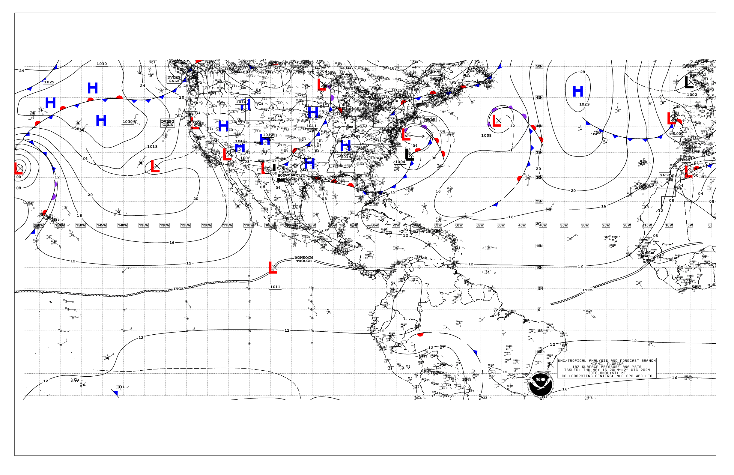
Based on 1800 UTC surface analysis and satellite imagery through
2230 UTC.
...MONSOON TROUGH/ITCZ...
The monsoon trough extends from the coast of Guinea near 11N15W to
04N30W. The ITCZ extends from 04N30W to 03N40W. Scattered moderate
convection is noted from 00N to 08N between 10W and 27W.
...GULF OF MEXICO...
The tail-end of a cold front extends off the Tampa Bay, Florida
coast. A pre-frontal trough extends from the Ft. Myers, Florida
coast to the western Gulf near 25N96W. Scattered moderate
convection is noted in the southeast Gulf from 23N to 26N between
83W and 85W. Light to gentle winds mostly prevail over the entire
basin, except moderate to locally fresh winds along the northern
Yucatan coast. Seas are 3 ft or less over the Gulf.
Areas of haze and smoke from agricultural fires in Mexico are in
most of the western half of the Gulf of Mexico. The visibilities
are being reduced in some areas.
For the forecast, scattered showers and thunderstorms will
prevail over the Straits of Florida this evening. Gusty winds
along with rough seas will prevail near the convection. Moderate
to fresh SE winds prevail elsewhere, with slight seas. Hazy
conditions due to agricultural fires in Mexico continue across
most of the western Gulf and Bay of Campeche.
...CARIBBEAN SEA...
Ridging extends across the area from high pressure NE of the area.
Strong thunderstorms are noted in the SW basin along the eastern
Pacific monsoon trough, S of 13N between 73W and 82W. Frequent
lightning and gusty winds are likely occurring in these storms.
Strong thunderstorms are also impacting Cuba and adjacent waters.
Fresh to strong E to NE winds are noted in the south-central
basin, including the Gulf of Venezuela, S of 17N. Seas are 6 to 8
ft in this area. Moderate to fresh winds are also noted along the
northern Honduras coast. Otherwise, gentle to moderate winds
prevail across the rest of the basin. Seas ranging 2 to 4 ft are
noted in the eastern, southwest, and northwest Caribbean.
Areas of haze and smoke from agricultural fires in Central
America may be impacting portions of the NW Caribbean,
particularly in the Gulf of Honduras.
For the forecast, a deep layer trough will dig southward across
the western Caribbean Mon night through Fri, supporting active
weather E of 80W Tue through Fri. Fresh to strong E to SE winds
will develop in the central Caribbean Tue and shift eastward
through Thu while diminishing to mostly fresh speeds. Smoke due to
agricultural fires in Central America continues across the Gulf
of Honduras, but continue to thin out.
...ATLANTIC OCEAN...
In the SW N Atlantic off the Florida coast, a cold front extends
from 31N66W to the Melbourne, Florida coast. Scattered moderate to
strong convection is noted from 26N to 31N between 65W and 77W.
Strong thunderstorms are also impacting Cuba and adjacent waters.
Moderate to fresh N to NE winds are noted off the Florida coast,
with moderate to fresh SW winds ahead of the front N of 28N and E
of 73W. Seas are 4 to 7 ft in the area of fresh winds off the
Florida coast. Otherwise, light to gentle winds prevail across the
western Atlantic. Seas are 3 to 5 ft across the rest of the
region.
In the central Atlantic, surface ridging extends across the area
anchored by a 1023 mb high pressure near 33N25W. Under the
influence of the high, light to gentle winds prevail N of 20N to
31N. South of 20N, moderate NE to E winds prevail. Seas are to 4
ft.
In the eastern Atlantic, the same 1023 mb high pressure is
influencing this region. The pressure gradient between the high
and lower pressure over Africa is producing fresh to strong winds
off the west African coast N of 15N and E of 20W. Seas 6 to 8 ft
are likely occurring along the Western Sahara coast. Otherwise,
gentle to moderate NE winds prevail with seas 4 to 6 ft.
For the forecast W of 55W, the cold front off the Florida coast
will move southeastward and stall from near 31N72W to SE Florida
late Tue. A trough will develop southeast of the weakening front
and extend into the central Bahamas early on Wed, and drift
eastward through Fri night. Fresh winds and moderate seas will
prevail in the western Atlantic with the front/trough through
midweek, then light to gentle winds and slight seas are expected
through Fri.
$$
AReinhart


