


NHC Offshore Waters Forecasts
Hover to view popup zone forecast; click a zone to view related text forecast below. Show All Text Below
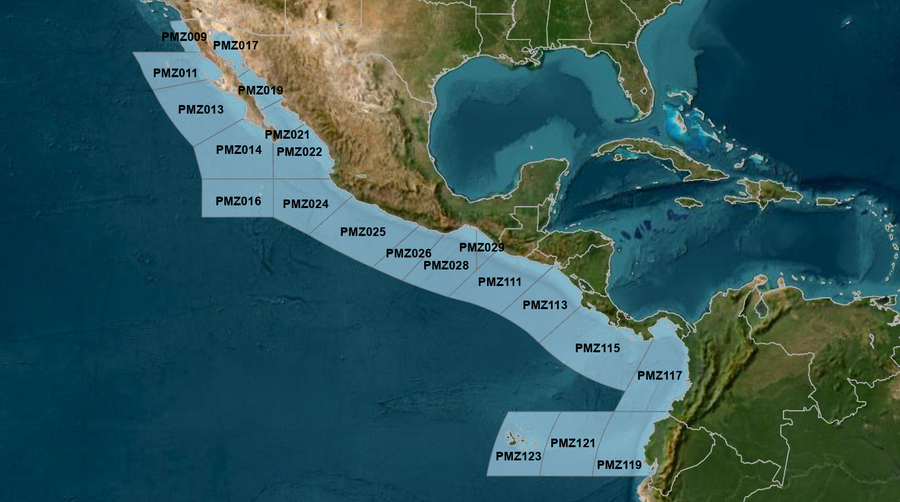
East Pacific within 250 nm of Mexico (OFFPZ7)
000
FZPN27 KNHC 170931
OFFPZ7

Offshore Waters Forecast
NWS National Hurricane Center Miami, FL
231 AM PDT Fri May 17 2024

Offshore Waters Forecast for the E Pacific within 250 nm of
Mexico

Seas given as significant wave height, which is the average
height of the highest 1/3 of the waves. Individual waves may be
more than twice the significant wave height.
Synopsis for the E Pacific within 250 nm of Mexico
PMZ001-172145-
Synopsis for the E Pacific within 250 nm of Mexico
231 AM PDT Fri May 17 2024

.SYNOPSIS...A ridge will dominate the offshore forecast waters
of Baja California producing moderate to locally fresh NW to N
winds and moderate seas through the upcoming weekend. In the Gulf
of California, expect gentle to locally moderate southerly winds
and seas of 1 to 3 ft, with the exception of 3 to 5 ft near the
entrance to the Gulf. These marine conditions will persist
through Sun. Light to gentle winds are expected across the
remainder of the Mexican offshore waters through Sun with
moderate seas in long period SW swell. Looking ahead, a broad
area of low pressure is forecast to form several hundred miles to
the south of southern Mexico during the next day or two. Some
gradual development of this system is possible thereafter as it
moves slowly to the west or west-northwest, remaining south of
the coast of Mexico by the middle portion of next week.
PMZ009 Zone Forecast
PMZ009-172145-
Mexico Border S to 30N within 60 nm of shore-
231 AM PDT Fri May 17 2024

.TODAY...NW winds 15 to 20 kt. Seas 3 to 5 ft. Period
18 seconds.
.TONIGHT...NW winds 10 to 15 kt. Seas 3 to 5 ft. Period
18 seconds.
.SAT...NW winds 10 to 15 kt N of 31N, and NW 15 to 20 kt S of
31N. Seas 3 to 5 ft. Period 19 seconds.
.SAT NIGHT...NW winds 15 to 20 kt. Seas 4 to 6 ft. Period
19 seconds.
.SUN...NW winds 10 to 15 kt N of 31N, and NW 15 to 20 kt S of
31N. Seas 4 to 6 ft. Period 18 seconds.
.SUN NIGHT...NW winds 10 to 15 kt N of 31N, and NW 15 to 20 kt S
of 31N. Seas 4 to 6 ft. Period 17 seconds.
.MON...NW winds 10 to 15 kt. Seas 4 to 6 ft. Period 16 seconds.
.MON NIGHT...NW winds 10 to 15 kt N of 31N, and NW 15 to 20 kt S
of 31N. Seas 5 to 7 ft in NW swell. Period 16 seconds.
.TUE...NW winds 10 to 15 kt. Seas 5 to 7 ft in NW swell. Period
17 seconds.
.TUE NIGHT...NW winds 10 to 15 kt. Seas 5 to 7 ft in NW swell.
Period 16 seconds.
Forecaster GR
PMZ011 Zone Forecast
PMZ011-172145-
30N to Punta Eugenia within 250 nm of shore-
231 AM PDT Fri May 17 2024

.TODAY...NW to N winds 15 to 20 kt. Seas 4 to 6 ft. Period
16 seconds.
.TONIGHT...NW winds 10 to 15 kt. Seas 4 to 6 ft. Period
17 seconds.
.SAT...NW to N winds 10 to 15 kt. Seas 4 to 6 ft. Period
19 seconds.
.SAT NIGHT...NW to N winds 15 to 20 kt. Seas 4 to 6 ft. Period
19 seconds.
.SUN...NW winds 15 to 20 kt. Seas 5 to 7 ft. Period 17 seconds.
.SUN NIGHT...NW to N winds 15 to 20 kt. Seas 5 to 7 ft. Period
17 seconds.
.MON...NW to N winds 15 to 20 kt. Seas 6 to 8 ft in NW swell.
Period 13 seconds.
.MON NIGHT...NW to N winds 15 to 20 kt. Seas 6 to 9 ft in NW
swell. Period 13 seconds.
.TUE...NW winds 15 to 20 kt. Seas 7 to 10 ft in NW swell. Period
14 seconds.
.TUE NIGHT...NW winds 15 kt. Seas 6 to 9 ft in NW swell. Period
14 seconds.
Forecaster GR
PMZ013 Zone Forecast
PMZ013-172145-
Punta Eugenia to Cabo San Lazaro within 250 nm offshore-
231 AM PDT Fri May 17 2024

.TODAY...NW to N winds 15 to 20 kt. Seas 5 to 7 ft. Period
17 seconds.
.TONIGHT...NW to N winds 15 to 20 kt. Seas 5 to 7 ft. Period
18 seconds.
.SAT...NW to N winds 15 to 20 kt. Seas 5 to 7 ft. Period
19 seconds.
.SAT NIGHT...NW to N winds 15 to 20 kt. Seas 5 to 7 ft. Period
19 seconds.
.SUN...NW to N winds 15 to 20 kt. Seas 5 to 7 ft. Period
17 seconds.
.SUN NIGHT...NW to N winds 15 to 20 kt. Seas 6 to 8 ft in NW
swell. Period 16 seconds.
.MON...NW to N winds 15 to 20 kt. Seas 6 to 8 ft in NW swell.
Period 16 seconds.
.MON NIGHT...NW to N winds 15 to 20 kt. Seas 6 to 8 ft in NW
swell. Period 17 seconds.
.TUE...NW to N winds 15 to 20 kt. Seas 6 to 8 ft in NW swell.
Period 17 seconds.
.TUE NIGHT...NW to N winds 15 to 20 kt. Seas 6 to 8 ft in NW
swell. Period 16 seconds.
Forecaster GR
PMZ014 Zone Forecast
PMZ014-172145-
Cabo San Lazaro to Cabo San Lucas within 350 nm offshore N of
20N-
231 AM PDT Fri May 17 2024

.TODAY...NW to N winds 15 to 20 kt. Seas 5 to 7 ft. Period
17 seconds.
.TONIGHT...NW to N winds 15 to 20 kt. Seas 5 to 7 ft. Period
19 seconds.
.SAT...NW to N winds 10 to 15 kt. Seas 5 to 7 ft in NW swell.
Period 19 seconds.
.SAT NIGHT...NW to N winds 10 to 15 kt. Seas 5 to 7 ft in NW
swell. Period 18 seconds.
.SUN...NW to N winds 10 to 15 kt. Seas 5 to 7 ft in W to NW
swell. Period 17 seconds.
.SUN NIGHT...NW to N winds 10 to 15 kt. Seas 5 to 7 ft in W to
NW swell. Period 16 seconds.
.MON...NW to N winds 10 to 15 kt. Seas 6 to 8 ft in W swell.
Period 16 seconds.
.MON NIGHT...NW to N winds 15 to 20 kt. Seas 6 to 8 ft in W to
NW swell. Period 17 seconds.
.TUE...NW to N winds 15 to 20 kt. Seas 6 to 8 ft in NW swell.
Period 16 seconds.
.TUE NIGHT...NW to N winds 15 to 20 kt. Seas 6 to 8 ft in NW
swell. Period 15 seconds.
Forecaster GR
PMZ016 Zone Forecast
PMZ016-172145-
From 17N to 20N Between 110W and 115W including the
Revillagigedo Islands-
231 AM PDT Fri May 17 2024

.TODAY...N winds 10 to 15 kt. Seas 5 to 7 ft in NW swell. Period
15 seconds.
.TONIGHT...N winds 10 to 15 kt. Seas 5 to 7 ft in NW swell.
Period 19 seconds.
.SAT...N to NE winds 10 to 15 kt. Seas 5 to 7 ft in W swell.
Period 19 seconds.
.SAT NIGHT...N winds 10 to 15 kt. Seas 5 to 7 ft in SW to W
swell. Period 18 seconds.
.SUN...N winds 10 to 15 kt. Seas 5 to 7 ft in S to SW swell.
Period 16 seconds.
.SUN NIGHT...N winds 10 to 15 kt. Seas 5 to 7 ft in S to SW
swell. Period 16 seconds.
.MON...N winds 10 to 15 kt. Seas 5 to 7 ft in S to SW swell.
Period 16 seconds.
.MON NIGHT...N winds 10 to 15 kt. Seas 5 to 7 ft in SW swell.
Period 17 seconds.
.TUE...N winds 10 to 15 kt. Seas 5 to 7 ft in W swell. Period
15 seconds.
.TUE NIGHT...N winds 10 to 15 kt. Seas 5 to 7 ft in W to NW
swell. Period 15 seconds.
Forecaster GR
PMZ017 Zone Forecast
PMZ017-172145-
Northern Gulf of California-
231 AM PDT Fri May 17 2024

.TODAY...SE to S winds 10 kt. Seas 3 ft or less. Period
4 seconds.
.TONIGHT...S winds 10 kt. Seas 3 ft or less. Period 4 seconds.
.SAT...S to SW winds 10 kt, shifting to NW in the afternoon.
Seas 3 ft or less. Period 4 seconds.
.SAT NIGHT...SW to W winds 10 to 15 kt. Seas 3 ft or less.
Period 8 seconds.
.SUN...SW winds 10 to 15 kt. Seas 3 ft or less. Period
4 seconds.
.SUN NIGHT...S to SW winds 10 kt. Seas 3 ft or less. Period
4 seconds.
.MON...S winds 10 kt. Seas 3 ft or less. Period 3 seconds.
.MON NIGHT...SW to W winds 15 to 20 kt. Seas 3 to 5 ft. Period
4 seconds.
.TUE...NW winds 10 to 15 kt. Seas 3 ft or less. Period
4 seconds.
.TUE NIGHT...SW to W winds 10 kt. Seas 3 ft or less. Period
4 seconds.
Forecaster GR
PMZ019 Zone Forecast
PMZ019-172145-
Central Gulf of California-
231 AM PDT Fri May 17 2024

.TODAY...Variable winds less than 5 kt, becoming SW to W 10 kt
in the afternoon. Seas 3 ft or less. Period 11 seconds.
.TONIGHT...SW winds 10 kt. Seas 3 ft or less. Period 11 seconds.
.SAT...Variable winds less than 5 kt, becoming W 10 kt in the
afternoon. Seas 3 ft or less. Period 12 seconds.
.SAT NIGHT...SW to W winds 10 kt, shifting to NW late. Seas 3 ft
or less. Period 14 seconds.
.SUN...NW winds 10 kt. Seas 3 ft or less. Period 11 seconds.
.SUN NIGHT...W to NW winds 10 to 15 kt. Seas 3 ft or less.
Period 10 seconds.
.MON...NW winds 10 kt. Seas 3 ft or less. Period 5 seconds.
.MON NIGHT...W to NW winds 10 to 15 kt. Seas 3 ft or less.
Period 6 seconds.
.TUE...NW winds 10 to 15 kt. Seas 3 ft or less. Period
4 seconds.
.TUE NIGHT...NW winds 10 to 15 kt. Seas 3 ft or less. Period
4 seconds.
Forecaster GR
PMZ021 Zone Forecast
PMZ021-172145-
Southern Gulf of California-
231 AM PDT Fri May 17 2024

.TODAY...NW winds 10 kt. Seas 3 ft or less. Period 18 seconds.
.TONIGHT...W to NW winds 10 kt in the evening, becoming variable
winds less than 5 kt. Seas 2 to 4 ft in S swell. Period
17 seconds.
.SAT...Variable winds less than 5 kt, becoming S to SW 10 kt in
the afternoon. Seas 2 to 4 ft. Period 19 seconds.
.SAT NIGHT...Variable winds less than 5 kt. Seas 2 to 4 ft in S
swell. Period 19 seconds.
.SUN...W winds 10 kt. Seas 2 to 4 ft. Period 14 seconds.
.SUN NIGHT...W winds 10 kt. Seas 3 to 5 ft. Period 13 seconds.
.MON...SW to W winds 10 kt. Seas 3 to 5 ft. Period 13 seconds.
.MON NIGHT...W winds 10 kt. Seas 3 to 5 ft. Period 13 seconds.
.TUE...Variable winds less than 5 kt. Seas 3 to 5 ft in S swell.
Period 14 seconds.
.TUE NIGHT...W to NW winds 10 kt. Seas 3 to 5 ft. Period
13 seconds.
Forecaster GR
PMZ022 Zone Forecast
PMZ022-172145-
N of 20N E of 110W to the Entrance of the Gulf of California-
231 AM PDT Fri May 17 2024

.TODAY...NW to N winds 10 to 15 kt. Seas 5 to 7 ft in SW to W
swell. Period 18 seconds.
.TONIGHT...NW to N winds 10 kt. Seas 5 to 7 ft in SW swell.
Period 18 seconds.
.SAT...NW winds 10 kt. Seas 4 to 6 ft in S to SW swell. Period
19 seconds.
.SAT NIGHT...W to NW winds 10 kt. Seas 4 to 6 ft in S to SW
swell. Period 19 seconds.
.SUN...SW to W winds 10 kt. Seas 4 to 6 ft in S to SW swell.
Period 17 seconds.
.SUN NIGHT...W to NW winds 10 kt. Seas 4 to 6 ft in S to SW
swell. Period 16 seconds.
.MON...SW winds 10 kt. Seas 4 to 6 ft in S to SW swell. Period
16 seconds.
.MON NIGHT...W to NW winds 10 kt. Seas 4 to 6 ft in S to SW
swell. Period 17 seconds.
.TUE...Variable winds less than 5 kt. Seas 4 to 6 ft in S to SW
swell. Period 17 seconds.
.TUE NIGHT...W winds 10 kt. Seas 4 to 6 ft in S to SW swell.
Period 16 seconds.
Forecaster GR
PMZ024 Zone Forecast
PMZ024-172145-
Colima and Jalisco within 300 nm offshore S of 20N and E of
110W-
231 AM PDT Fri May 17 2024

.TODAY...NW to N winds 10 to 15 kt. Seas 5 to 7 ft in SW to W
swell. Period 18 seconds.
.TONIGHT...NW to N winds 10 kt. Seas 5 to 7 ft in SW swell.
Period 19 seconds.
.SAT...N to NE winds 10 kt in the morning, becoming variable
winds less than 5 kt. Seas 5 to 7 ft in S to SW swell. Period
19 seconds.
.SAT NIGHT...NW to N winds 10 kt. Seas 5 to 7 ft in S to SW
swell. Period 18 seconds.
.SUN...Variable winds less than 5 kt. Seas 5 to 7 ft in S to SW
swell. Period 17 seconds.
.SUN NIGHT...NW winds 10 kt. Seas 5 to 7 ft in S to SW swell.
Period 16 seconds.
.MON...Variable winds less than 5 kt. Seas 5 to 7 ft in S to SW
swell. Period 16 seconds.
.MON NIGHT...NW winds 10 kt. Seas 5 to 7 ft in S to SW swell.
Period 17 seconds.
.TUE...Variable winds less than 5 kt. Seas 4 to 6 ft in S to SW
swell. Period 16 seconds.
.TUE NIGHT...NW winds 10 kt. Seas 4 to 6 ft in S to SW swell.
Period 15 seconds.
Forecaster GR
PMZ025 Zone Forecast
PMZ025-172145-
Michoacan and Guerrero within 250 nm offshore-
231 AM PDT Fri May 17 2024

.TODAY...N winds 10 kt, shifting to W to NW in the afternoon.
Seas 5 to 7 ft in S to SW swell. Period 18 seconds.
.TONIGHT...Variable winds less than 5 kt. Seas 5 to 7 ft in S to
SW swell. Period 19 seconds.
.SAT...Within 60 nm of shore, variable winds less than 5 kt,
becoming SW to W 10 kt in the afternoon. Elsewhere, N to NE
winds 10 kt in the morning, becoming variable winds less than
5 kt. Seas 5 to 7 ft in S to SW swell. Period 19 seconds.
.SAT NIGHT...Within 60 nm of shore, W to NW winds 10 kt in the
evening, becoming variable winds less than 5 kt. Elsewhere,
variable winds less than 5 kt, becoming N 10 kt late.
Seas 5 to 7 ft in S to SW swell. Period 18 seconds.
.SUN...N winds 10 kt. Seas 5 to 7 ft in S to SW swell. Period
17 seconds.
.SUN NIGHT...N winds 10 kt. Seas 5 to 7 ft in S to SW swell.
Period 16 seconds.
.MON...Variable winds less than 5 kt Within 60 nm of shore, and
N to NE 10 to 15 kt Elsewhere. Seas 5 to 7 ft in S to SW swell.
Period 15 seconds.
.MON NIGHT...N to NE winds 10 kt. Seas 5 to 7 ft in S to SW
swell. Period 16 seconds.
.TUE...Variable winds less than 5 kt Within 60 nm of shore, and
NE 10 kt Elsewhere. Seas 4 to 6 ft in S to SW swell. Period
16 seconds.
.TUE NIGHT...N winds 10 kt. Seas 4 to 6 ft in S to SW swell.
Period 15 seconds.
Forecaster GR
PMZ026 Zone Forecast
PMZ026-172145-
Oaxaca W of Puerto Angel within 250 nm offshore-
231 AM PDT Fri May 17 2024

.TODAY...N of 14N, NW winds 10 kt, shifting to SW to W in the
afternoon. S of 14N, variable winds less than 5 kt. Seas 5 to
7 ft in S to SW swell. Period 19 seconds.
.TONIGHT...Variable winds less than 5 kt. Seas 5 to 7 ft in S to
SW swell. Period 20 seconds.
.SAT...Variable winds less than 5 kt. Seas 5 to 7 ft in SW
swell. Period 19 seconds.
.SAT NIGHT...N of 14N, N to NE winds 10 kt late.
Variable winds less than 5 kt in the evening. S of 14N, variable
winds less than 5 kt. Seas 5 to 7 ft in S to SW swell. Period
18 seconds. Scattered showers and isolated tstms through the
night.
.SUN...NE to E winds 10 kt. Seas 5 to 7 ft in S to SW swell.
Period 17 seconds.
.SUN NIGHT...E winds 10 kt. Seas 5 to 7 ft in S to SW swell.
Period 16 seconds.
.MON...E winds 10 kt. Seas 5 to 7 ft in SW swell. Period
15 seconds.
.MON NIGHT...SE winds 10 kt. Seas 5 to 7 ft in SW swell. Period
16 seconds.
.TUE...SE winds 10 kt. Seas 4 to 6 ft in S to SW swell. Period
16 seconds.
.TUE NIGHT...S to SW winds 10 to 15 kt. Seas 5 to 7 ft in S to
SW swell. Period 15 seconds.
Forecaster GR
PMZ028 Zone Forecast
PMZ028-172145-
Oaxaca E of Puerto Angel within 300 nm offshore including the
Gulf of Tehuantepec-
231 AM PDT Fri May 17 2024

.TODAY...N of 14N, SW to W winds 10 kt, shifting to S in the
afternoon. S of 14N, variable winds less than 5 kt. Seas 4 to
6 ft in SW swell. Period 19 seconds. Scattered showers and
isolated tstms through the day.
.TONIGHT...N of 14N, S to SW winds 10 kt, shifting to SE late. S
of 14N, variable winds less than 5 kt, becoming SW
to W 10 kt late. Seas 4 to 6 ft in SW swell. Period
20 seconds. Scattered showers and isolated tstms through the
night.
.SAT...N of 14N, E to SE winds 10 to 15 kt. S of 14N, variable
winds less than 5 kt, becoming N 10 kt in the afternoon. Seas
5 to 7 ft in SW swell. Period 19 seconds. Scattered showers and
isolated tstms through the day.
.SAT NIGHT...N of 14N, E to SE winds 10 kt. S of 14N, variable
winds less than 5 kt, becoming N to NE 10 kt late.
Seas 5 to 7 ft in SW swell. Period 19 seconds. Scattered showers
and isolated tstms through the night.
.SUN...E to SE winds 10 kt. Seas 5 to 7 ft in SW swell. Period
17 seconds.
.SUN NIGHT...SE to S winds 10 kt. Seas 5 to 7 ft in S to SW
swell. Period 16 seconds.
.MON...SE winds 10 kt. Seas 5 to 7 ft in S to SW swell. Period
15 seconds.
.MON NIGHT...S winds 10 kt. Seas 5 to 7 ft in S to SW swell.
Period 16 seconds.
.TUE...Variable winds less than 5 kt. Seas 4 to 6 ft in S to SW
swell. Period 16 seconds.
.TUE NIGHT...SW winds 10 to 15 kt. Seas 4 to 6 ft. Period
15 seconds.
Forecaster GR
PMZ029 Zone Forecast
PMZ029-172145-
Offshore Chiapas E of 94W-
231 AM PDT Fri May 17 2024

.TODAY...SE winds 10 to 15 kt. Seas 4 to 6 ft. Period
18 seconds. Scattered showers and isolated tstms through the
day.
.TONIGHT...SE winds 10 to 15 kt. Seas 4 to 6 ft. Period
20 seconds. Scattered showers and isolated tstms.
.SAT...SE to S winds 10 to 15 kt. Seas 4 to 6 ft. Period
20 seconds. Scattered showers and isolated tstms through the
day.
.SAT NIGHT...E to SE winds 10 kt in the evening, becoming
variable winds less than 5 kt. Seas 4 to 6 ft in SW swell.
Period 19 seconds. Scattered showers and isolated tstms.
.SUN...Variable winds less than 5 kt E of 93W, and SE 10 kt W of
93W. Seas 4 to 6 ft in SW swell. Period 17 seconds.
.SUN NIGHT...SE winds 10 kt. Seas 5 to 7 ft in SW swell. Period
17 seconds.
.MON...Variable winds less than 5 kt. Seas 5 to 7 ft in SW
swell. Period 16 seconds.
.MON NIGHT...Variable winds less than 5 kt. Seas 5 to 7 ft in SW
swell. Period 15 seconds.
.TUE...W winds 10 kt. Seas 4 to 6 ft in SW swell. Period
17 seconds.
.TUE NIGHT...SW to W winds 10 kt. Seas 4 to 6 ft in SW swell.
Period 16 seconds.
Forecaster GR
East Pacific offshore of Central America, Colombia, & Ecuador (OFFPZ8)
000
FZPN28 KNHC 170931
OFFPZ8

Offshore Waters Forecast
NWS National Hurricane Center Miami, FL
231 AM PDT Fri May 17 2024

Offshore Waters Forecast for the E Pacific within 250 nm of
Central America, Colombia, and within 750 nm of Ecuador

Seas given as significant wave height, which is the average
height of the highest 1/3 of the waves. Individual waves may be
more than twice the significant wave height.
Synopsis for the E Pacific within 250 nm of Central America, Colombia, and within 750 nm of Ecuador
PMZ101-172145-
Synopsis for the E Pacific within 250 nm of Central America,
Colombia, and within 750 nm of Ecuador
231 AM PDT Fri May 17 2024

.SYNOPSIS...Gentle to moderate southerly winds are forecast
south of the monsoon trough, with light to gentle winds north of
the monsoon trough, through the end of the week. Southerly swell
moving through the regional waters will support seas of 4 to
6 ft through the remainder of the week, building to 6 to 8 ft
between Ecuador and the Galapagos Islands this weekend.
PMZ111 Zone Forecast
PMZ111-172145-
Guatemala and El Salvador to 250 nm offshore-
231 AM PDT Fri May 17 2024

.TODAY...SE to S winds 10 to 15 kt. Seas 4 to 6 ft. Period
18 seconds. Scattered showers and isolated tstms.
.TONIGHT...S to SW winds 10 to 15 kt. Seas 5 to 7 ft in SW
swell. Period 20 seconds. Scattered showers and isolated tstms
through the night.
.SAT...S winds 10 kt. Seas 5 to 7 ft in SW swell. Period
20 seconds. Scattered showers and isolated tstms.
.SAT NIGHT...S to SW winds 10 kt, shifting to W late.
Seas 5 to 7 ft in SW swell. Period 19 seconds. Scattered showers
and isolated tstms through the night.
.SUN...SE winds 10 kt. Seas 5 to 7 ft in SW swell. Period
17 seconds.
.SUN NIGHT...SW winds 10 kt. Seas 5 to 7 ft in SW swell. Period
16 seconds.
.MON...Variable winds less than 5 kt. Seas 5 to 7 ft in SW
swell. Period 16 seconds.
.MON NIGHT...S to SW winds 10 kt. Seas 5 to 7 ft in SW swell.
Period 16 seconds.
.TUE...W winds 10 kt. Seas 5 to 7 ft in SW swell. Period
16 seconds.
.TUE NIGHT...SW to W winds 10 kt. Seas 4 to 6 ft in SW swell.
Period 16 seconds.
Forecaster GR
PMZ113 Zone Forecast
PMZ113-172145-
El Salvador to North Costa Rica including the Gulfs of Fonseca
and Papagayo-
231 AM PDT Fri May 17 2024

.TODAY...Variable winds less than 5 kt Offshore Gulf of
Papagayo, and SW 10 to 15 kt Elsewhere. Seas 4 to 6 ft in SW
swell. Period 18 seconds. Scattered showers and isolated tstms
through the day.
.TONIGHT...Variable winds less than 5 kt Offshore Gulf of
Papagayo, and SW to W 10 kt Elsewhere. Seas 4 to 6 ft in SW
swell. Period 20 seconds. Scattered showers and isolated tstms
through the night.
.SAT...W winds 10 kt. Seas 4 to 6 ft in SW swell. Period
20 seconds. Scattered showers and isolated tstms through the
day.
.SAT NIGHT...W winds 10 kt. Seas 4 to 6 ft in SW swell. Period
19 seconds. Scattered showers and isolated tstms through the
night.
.SUN...NE to E winds 15 to 20 kt Offshore Gulf of Papagayo, and
NE 10 kt Elsewhere. Seas 4 to 6 ft in SW swell. Period
17 seconds.
.SUN NIGHT...SW to W winds 10 kt. Seas 4 to 6 ft in SW swell.
Period 16 seconds.
.MON...N to NE winds 10 to 15 kt. Seas 4 to 6 ft. Period
16 seconds.
.MON NIGHT...SW winds 10 kt. Seas 4 to 6 ft in SW swell. Period
17 seconds.
.TUE...NW winds 10 to 15 kt. Seas 4 to 6 ft. Period 17 seconds.
.TUE NIGHT...Variable winds less than 5 kt Offshore Gulf of
Papagayo, and SW to W 10 to 15 kt Elsewhere. Seas 4 to 6 ft.
Period 16 seconds.
Forecaster GR
PMZ115 Zone Forecast
PMZ115-172145-
North Costa Rica to West Panama to 250 nm offshore-
231 AM PDT Fri May 17 2024

.TODAY...SW winds 10 kt. Seas 3 to 5 ft. Period 18 seconds.
Scattered showers and isolated tstms through the day.
.TONIGHT...SW to W winds 10 kt. Seas 3 to 5 ft. Period
20 seconds. Scattered showers and isolated tstms through the
night.
.SAT...Near the Azuero Peninsula, variable winds less than 5 kt,
becoming W 10 kt in the afternoon. Elsewhere, SW to W winds
10 kt. Seas 3 to 5 ft. Period 19 seconds. Scattered showers and
isolated tstms through the day.
.SAT NIGHT...SW to W winds 10 kt. Seas 3 to 5 ft. Period
19 seconds. Scattered showers and isolated tstms through the
night.
.SUN...SW to W winds 10 kt. Seas 3 to 5 ft. Period 17 seconds.
.SUN NIGHT...SW to W winds 10 to 15 kt. Seas 3 to 5 ft. Period
16 seconds.
.MON...SW to W winds 10 to 15 kt. Seas 4 to 6 ft. Period
17 seconds.
.MON NIGHT...SW to W winds 10 to 15 kt. Seas 4 to 6 ft. Period
17 seconds.
.TUE...SW to W winds 10 to 15 kt. Seas 5 to 7 ft in S to SW
swell. Period 17 seconds.
.TUE NIGHT...SW to W winds 10 to 15 kt. Seas 5 to 7 ft in S to
SW swell. Period 16 seconds.
Forecaster GR
PMZ117 Zone Forecast
PMZ117-172145-
East Panama and Colombia including the Gulf of Panama-
231 AM PDT Fri May 17 2024

.TODAY...SW to W winds 10 kt. Seas 2 to 4 ft. Period 18 seconds.
Scattered showers and isolated tstms through the day.
.TONIGHT...SW to W winds 10 kt. Seas 3 to 5 ft. Period
20 seconds. Scattered showers and isolated tstms through the
night.
.SAT...Gulf of Panama, variable winds less than 5 kt, becoming
SW to W 10 kt in the afternoon. Elsewhere, SW to W winds 10 kt.
Seas 3 to 5 ft. Period 20 seconds.
.SAT NIGHT...SW winds 10 kt. Seas 3 to 5 ft. Period 19 seconds.
Scattered showers and isolated tstms through the night.
.SUN...SW to W winds 10 kt. Seas 3 to 5 ft. Period 17 seconds.
.SUN NIGHT...SW winds 10 to 15 kt. Seas 4 to 6 ft. Period
16 seconds.
.MON...SW winds 10 to 15 kt. Seas 4 to 6 ft. Period 17 seconds.
.MON NIGHT...SW to W winds 10 to 15 kt. Seas 4 to 6 ft. Period
18 seconds.
.TUE...SW winds 10 to 15 kt. Seas 4 to 6 ft. Period 17 seconds.
.TUE NIGHT...SW to W winds 10 to 15 kt. Seas 4 to 6 ft. Period
16 seconds.
Forecaster GR
PMZ119 Zone Forecast
PMZ119-172145-
Ecuador including the Gulf of Guayaquil to 250 nm offshore-
231 AM PDT Fri May 17 2024

.TODAY...S to SW winds 10 to 15 kt. Seas 3 to 5 ft. Period
20 seconds.
.TONIGHT...S to SW winds 10 to 15 kt. Seas 4 to 6 ft. Period
20 seconds.
.SAT...Gulf of Guayaquil, variable winds less than 5 kt,
becoming W 10 kt in the afternoon. Elsewhere, S to SW winds
10 to 15 kt. Seas 4 to 6 ft. Period 19 seconds.
.SAT NIGHT...S to SW winds 10 to 15 kt. Seas 4 to 6 ft. Period
18 seconds.
.SUN...S to SW winds 10 to 15 kt. Seas 4 to 6 ft. Period
16 seconds.
.SUN NIGHT...S to SW winds 10 to 15 kt. Seas 5 to 7 ft in SW
swell. Period 17 seconds.
.MON...S to SW winds 10 to 15 kt. Seas 5 to 7 ft in SW swell.
Period 18 seconds.
.MON NIGHT...S to SW winds 10 to 15 kt. Seas 5 to 7 ft in SW
swell. Period 17 seconds.
.TUE...S to SW winds 10 to 15 kt. Seas 5 to 7 ft in SW swell.
Period 16 seconds.
.TUE NIGHT...S to SW winds 10 to 15 kt. Seas 4 to 6 ft. Period
15 seconds.
Forecaster GR
PMZ121 Zone Forecast
PMZ121-172145-
Ecuador between 250 and 500 nm offshore-
231 AM PDT Fri May 17 2024

.TODAY...SE to S winds 10 kt. Seas 4 to 6 ft in SW swell. Period
20 seconds.
.TONIGHT...SE to S winds 10 kt. Seas 4 to 6 ft in SW swell.
Period 19 seconds.
.SAT...SE to S winds 10 kt. Seas 4 to 6 ft in SW swell. Period
18 seconds.
.SAT NIGHT...SE to S winds 10 kt. Seas 5 to 7 ft in SW swell.
Period 17 seconds.
.SUN...SE to S winds 10 kt. Seas 5 to 7 ft in SW swell. Period
16 seconds.
.SUN NIGHT...SE to S winds 10 kt. Seas 5 to 7 ft in S to SW
swell. Period 17 seconds.
.MON...SE to S winds 10 kt. Seas 5 to 7 ft in S to SW swell.
Period 17 seconds.
.MON NIGHT...SE to S winds 10 kt. Seas 5 to 7 ft in S to SW
swell. Period 16 seconds.
.TUE...S winds 10 to 15 kt. Seas 5 to 7 ft in S to SW swell.
Period 15 seconds.
.TUE NIGHT...SE to S winds 10 kt. Seas 5 to 7 ft in S to SW
swell. Period 15 seconds.
Forecaster GR
PMZ123 Zone Forecast
PMZ123-172145-
Offshore Galapagos Islands-
231 AM PDT Fri May 17 2024

.TODAY...SE to S winds 10 kt. Seas 4 to 6 ft in S to SW swell.
Period 19 seconds.
.TONIGHT...SE to S winds 10 to 15 kt. Seas 4 to 6 ft. Period
19 seconds.
.SAT...SE winds 10 kt. Seas 5 to 7 ft in S to SW swell. Period
18 seconds.
.SAT NIGHT...SE winds 10 kt. Seas 5 to 7 ft in S to SW swell.
Period 17 seconds.
.SUN...SE winds 10 kt. Seas 6 to 8 ft in S to SW swell. Period
16 seconds.
.SUN NIGHT...SE winds 10 kt. Seas 6 to 8 ft in S to SW swell.
Period 16 seconds.
.MON...SE to S winds 10 kt. Seas 6 to 8 ft in S to SW swell.
Period 16 seconds.
.MON NIGHT...SE to S winds 10 kt. Seas 5 to 7 ft in S to SW
swell. Period 15 seconds.
.TUE...SE to S winds 10 kt. Seas 5 to 7 ft in S to SW swell.
Period 14 seconds.
.TUE NIGHT...SE to S winds 10 kt. Seas 5 to 7 ft in S to SW
swell. Period 14 seconds.
Forecaster GR
Tropical North Atlantic High Seas (HSFAT2)
000
FZNT02 KNHC 170845
HSFAT2

HIGH SEAS FORECAST
NWS NATIONAL HURRICANE CENTER MIAMI FL
1030 UTC FRI MAY 17 2024

SUPERSEDED BY NEXT ISSUANCE IN 6 HOURS

SEAS GIVEN AS SIGNIFICANT WAVE HEIGHT...WHICH IS THE AVERAGE
HEIGHT OF THE HIGHEST 1/3 OF THE WAVES. INDIVIDUAL WAVES MAY BE
MORE THAN TWICE THE SIGNIFICANT WAVE HEIGHT.

SECURITE

ATLANTIC FROM 07N TO 31N W OF 35W INCLUDING CARIBBEAN SEA AND
GULF OF MEXICO

SYNOPSIS VALID 0600 UTC FRI MAY 17.
24 HOUR FORECAST VALID 0600 UTC SAT MAY 18.
48 HOUR FORECAST VALID 0600 UTC SUN MAY 19.

.WARNINGS.

.NONE.

.SYNOPSIS AND FORECAST.

.ATLC WITHIN 31N66W TO 31N67W TO 30.5N67W TO 30N67W TO 30.5N67W
TO 31N66W WINDS 20 KT OR LESS. SEAS 8 FT IN W SWELL.
.18 HOUR FORECAST CONDITIONS IMPROVE. WINDS 20 KT OR LESS. SEAS
LESS THAN 8 FT.

.CARIBBEAN WITHIN 18N85W TO 19N85W TO 19N86W TO 18N87W TO 17N86W
TO 16N85W TO 18N85W E TO SE WINDS 20 TO 25 KT. SEAS TO 8 FT IN E
TO SE SWELL.
.24 HOUR FORECAST WITHIN 18N84W TO 20N85W TO 20N87W TO 18N88W TO
17N87W TO 16N85W TO 18N84W...INCLUDING THE GULF OF HONDURAS...
SE WINDS 20 TO 30 KT. SEAS TO 10 FT IN SE SWELL.
.48 HOUR FORECAST WITHIN 18N85W TO 19N86W TO 18N87W TO 17N87W TO
16N86W TO 17N85W TO 18N85W...INCLUDING THE GULF OF HONDURAS... E
TO SE WINDS 20 TO 25 KT. SEAS TO 9 FT IN E TO SE SWELL.

.CARIBBEAN WITHIN 12N74W TO 12N75W TO 11N76W TO 11N75W TO 12N74W
NE TO E WINDS 20 TO 25 KT. SEAS LESS THAN 8 FT.
.24 HOUR FORECAST WITHIN 12N74W TO 13N74W TO 13N75W TO 12N75W TO
11N75W TO 12N74W NE TO E WINDS 20 TO 25 KT. SEAS LESS THAN 8 FT.
.48 HOUR FORECAST WITHIN 13N72W TO 14N74W TO 13N77W TO 12N77W TO
11N76W TO 12N73W TO 13N72W NE TO E WINDS 20 TO 25 KT. SEAS TO 9
FT IN NE TO E SWELL.

.GULF OF MEXICO WITHIN 23N88W TO 24N88W TO 24N89W TO 23N89W TO
22N89W TO 22N88W TO 23N88W SE WINDS 20 TO 25 KT. SEAS LESS THAN 8
FT.
.24 HOUR FORECAST WITHIN 24N87W TO 24N88W TO 24N89W TO 23N89W TO
23N88W TO 24N88W TO 24N87W SE WINDS 20 TO 25 KT. SEAS TO 9 FT IN
SE SWELL.
.48 HOUR FORECAST CONDITIONS IMPROVE. WINDS 20 KT OR LESS. SEAS
LESS THAN 8 FT.

.GULF OF MEXICO WITHIN 22N96W TO 22N97W TO 20N97W TO 19N94W TO
20N95W TO 22N96W...INCLUDING WITHIN 60 NM OF COAST OF
VERACRUZ... SE TO S WINDS 20 TO 30 KT. SEAS LESS THAN 8 FT.
.24 HOUR FORECAST S OF 19.5N BETWEEN 94W AND 95W S WINDS 20 TO
25 KT. SEAS LESS THAN 8 FT.
.30 HOUR FORECAST CONDITIONS IMPROVE. WINDS 20 KT OR LESS. SEAS
LESS THAN 8 FT.

.REMAINDER OF AREA WINDS 20 KT OR LESS. SEAS LESS THAN 8 FT.

$$
.FORECASTER STRIPLING. NATIONAL HURRICANE CENTER.
Tropical Northeast Pacific High Seas (HSFEP2)
000
FZPN03 KNHC 170930
HSFEP2

HIGH SEAS FORECAST
NWS NATIONAL HURRICANE CENTER MIAMI FL
1030 UTC FRI MAY 17 2024

SUPERSEDED BY NEXT ISSUANCE IN 6 HOURS

SEAS GIVEN AS SIGNIFICANT WAVE HEIGHT...WHICH IS THE AVERAGE
HEIGHT OF THE HIGHEST 1/3 OF THE WAVES. INDIVIDUAL WAVES MAY BE
MORE THAN TWICE THE SIGNIFICANT WAVE HEIGHT.

SECURITE

E PACIFIC FROM THE EQUATOR TO 30N E OF 140W AND 03.4S TO THE
EQUATOR E OF 120W

SYNOPSIS VALID 0600 UTC FRI MAY 17.
24 HOUR FORECAST VALID 0600 UTC SAT MAY 18.
48 HOUR FORECAST VALID 0600 UTC SUN MAY 19.

.WARNINGS.

.NONE.

.SYNOPSIS AND FORECAST.

.FROM 22N TO 27N BETWEEN 109W AND 115W NW TO N WINDS 20 TO 25
KT. SEAS LESS THAN 8 FT.
.24 HOUR FORECAST WINDS 20 KT OR LESS. SEAS LESS THAN 8 FT.

.FROM 06N TO 10N BETWEEN 101W AND 106W S TO SW WINDS 20 TO 25
KT. SEAS 8 TO 10 FT.
.24 HOUR FORECAST FROM 08N TO 11N BETWEEN 100W AND 104W S TO SW
WINDS 20 TO 25 KT. SEAS 8 TO 9 FT IN SW SWELL.
.48 HOUR FORECAST LITTLE CHANGE.

.12 HOUR FORECAST NW OF A LINE FROM 30N138W TO 29N140W WINDS 20
KT OR LESS. SEAS 8 FT IN NE SWELL.
.24 HOUR FORECAST NW OF A LINE FROM 30N138W TO 28N140W WINDS 20
KT OR LESS. SEAS 8 FT IN NE SWELL.
.30 HOUR FORECAST WINDS 20 KT OR LESS. SEAS LESS THAN 8 FT.

.18 HOUR FORECAST S OF 02S AND W OF 118W WINDS 20 KT OR LESS.
SEAS 8 FT IN SW SWELL.
.24 HOUR FORECAST S OF 02S AND W OF 115W WINDS 20 KT OR LESS.
SEAS 8 FT IN SW SWELL.
.36 HOUR FORECAST S OF A LINE FROM 03.4S102W TO 01S115W TO
00N120W WINDS 20 KT OR LESS. SEAS 8 FT IN SW SWELL.
.48 HOUR FORECAST S OF 01S BETWEEN 100W AND 112W WINDS 20 KT OR
LESS. SEAS 8 FT IN SW SWELL.

.REMAINDER OF AREA WINDS 20 KT OR LESS. SEAS LESS THAN 8 FT.

CONVECTION VALID AT 0900 UTC THU MAY 16...

.INTERTROPICAL CONVERGENCE ZONE/MONSOON TROUGH...
THE MONSOON TROUGH EXTENDS FROM A 1008 MB LOW PRESSURE LOCATED
OVER NORTHERN COLOMBIA NEAR 10N74W TO 12N95W TO 1008 MB LOW
PRESSURE SITUATED NEAR 10N105W TO 08N113W. THE ITCZ CONTINUES
FROM 08N113W TO BEYOND 05N140W. SCATTERED MODERATE TO ISOLATED
STRONG CONVECTION CAN BE FOUND FROM 05N TO 13N BETWEEN 82W AND
98W, AND FROM 08N TO 11N BETWEEN 103W AND 109W. SIMILAR
CONVECTIVE ACTIVITY IS NOTED FROM 10N TO 13N E OF 89W.

$$
.FORECASTER GR. NATIONAL HURRICANE CENTER.