000
AXNT20 KNHC 071705
TWDAT
Tropical Weather Discussion
NWS National Hurricane Center Miami FL
1805 UTC Fri Jun 7 2024
Tropical Weather Discussion for North America, Central America
Gulf of Mexico, Caribbean Sea, northern sections of South
America, and Atlantic Ocean to the African coast from the
Equator to 31N. The following information is based on satellite
imagery, weather observations, radar and meteorological analysis.
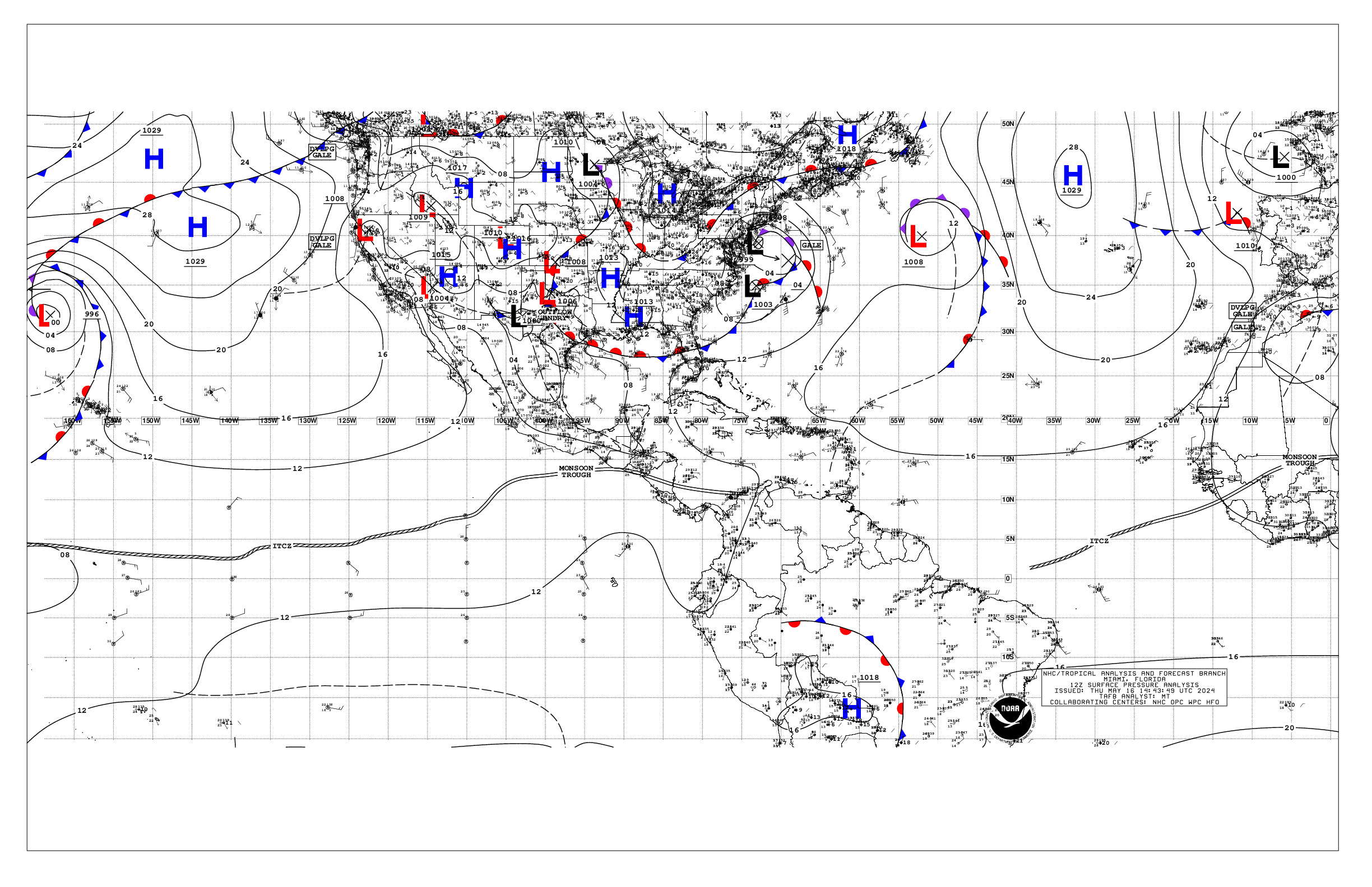
Based on 1200 UTC surface analysis and satellite imagery through
1650 UTC.
...SPECIAL FEATURES...
HEAVY RAINFALL IN THE NW CARIBBEAN SEA, AND IN HISPANIOLA:
Scattered to numerous strong rainshowers are from 17N to 20N
between 85W and the Yucatan Peninsula in the NW corner of the
Caribbean Sea. Isolated moderate to locally strong is elsewhere in
the Caribbean Sea from 16N northward between the Mona Passage and
80W. A NW-to-SE oriented surface trough passes through the
Isthmus of Tehuantepec of southern Mexico, to the northern
sections of Honduras. Scattered moderate to widely scattered
strong is in Cuba from 20N to 22N between 77W and 79W. Scattered
moderate to strong is in the Atlantic Ocean just to the north of
and to the east of the Bahamas from 21N to 28N between 66W and
73W. The monsoon trough is along 10N74W in Colombia, beyond 12N at
the coast of Nicaragua. Precipitation: scattered moderate to
widely scattered strong is from 15N southward between 74W and 80W.
Broad upper level cyclonic wind flow spans the areas that are
between 65W in the Atlantic Ocean and 90W in the Gulf of Mexico,
including in the Caribbean Sea. Ample tropical moisture continues
to move northward in the Caribbean Sea. Heavy rainshowers are
affecting the Gulf of Honduras, the Cayman Islands, Cuba, Jamaica,
Hispaniola, and the Bahamas. The hazards are: dangerous
lightning, rough seas, gusty winds, and low visibilities. The
soils remain saturated. It is possible that more heavy rain may
lead to flash flooding and mudslides, especially in mountainous
terrain. The rainfall for Hispaniola and Cuba will be influenced
heavily by daytime heating, the local sea breezes, and the
mountain upslope lifting. Mariners should exercise caution as
these conditions are forecast to continue through the weekend.
Please, refer to bulletins and forecasts that are from your local
weather bureau office for detailed information.
...TROPICAL WAVES...
An Atlantic Ocean tropical wave is along 41W/42W, from 11N
southward, moving westward about 10 knots. Precipitation:
scattered to numerous moderate, and widely scattered strong, is
from 07N to 11N between 39W and 51W.
An Atlantic Ocean tropical wave is along 51W, from 11N southward,
moving westward about 10 knots. Precipitation: scattered to
numerous moderate, and widely scattered strong, is from 07N to 11N
between 39W and 51W. Widely scattered moderate to isolated strong
is elsewhere from 11N southward between 50W and 60W. Comparatively
drier air in subsidence in water vapor imagery is within 200 nm
on either side of the line from 10N57W 14N52W 19N45W.
A Caribbean Sea tropical wave is along 66W/67W, from 14N
southward, moving westward 10 knots to 15 knots. Precipitation:
isolated moderate to locally strong is within 480 nm to the east
of the tropical wave, and within 210 nm to the west of the
tropical wave, inland in South America. No significant deep
convective precipitation is in the Caribbean Sea.
...MONSOON TROUGH/ITCZ...
The monsoon trough passes through the coastal plains of Guinea-
Bissau near 11N15W, to 07N20W and 06N23W. The ITCZ continues from
06N23W, to 05N27W 07N33W 06N41W 06N43W 06N48W 05N50W.
Precipitation: disorganized widely scattered moderate to isolated
strong is from 10N southward from 39W eastward.
...GULF OF MEXICO...
The surface pressure pattern consists of broad and elongated low
pressure with an inland Mexico NW-to-SE oriented surface trough.
A separate NE-to-SW oriented surface trough extends from the
Florida Panhandle northeastward. Isolated moderate rainshowers are
in the NE quadrant of the Gulf of Mexico. Comparatively drier air
in subsidence in the water vapor imagery is in the NW quadrant,
and from the Yucatan Channel into the SW corner of the area.
Gentle winds and slight seas cover the area.
A weak pressure gradient will support mainly gentle to moderate
winds the next several days. Winds will pulse to fresh near the
Yucatan Peninsula during the late afternoon and evening hours.
Hazy conditions due to agricultural fires over Central America and
Mexico will continue for at least the next couple of days,
reducing visibility to around 3 nm at times, mainly over the SW
Gulf.
...CARIBBEAN SEA...
Please, read the SPECIAL FEATURES section, for information about
the heavy rainfall event for the NW Caribbean Sea and for
Hispaniola.
Moderate seas are in the eastern one-third of the area, and in
the southern half of the central one-third. Slight seas are
elsewhere. Mostly fresh to some strong easterly winds are in the
Windward Passage. Fresh to strong SE winds are from 17N
southward from 70W eastward. Moderate SE winds are elsewhere to
20N between 60W and 70W. Mostly moderate to some fresh SE winds
are in the NW corner of the area. Mostly moderate to some fresh SE
winds are from 13N northward between 70W and 81W. Gentle winds
are elsewhere from 13N southward in the SW corner of the Caribbean
Sea.
The 24-hour rainfall totals in inches, for the period that ended
at 07/1200 UTC, are: 3.16 in Kingston in Jamaica; 0.78 in Montego
Bay in Jamaica; 0.49 in Monterrey in Mexico; 0.04 in Freeport in
the Bahamas; and 0.02 in San Juan in Puerto Rico. This
information is from the Pan American Temperature and Precipitation
Tables/MIATPTPAN.
A mid to upper level trough extending from the E Gulf of Mexico
to just E of the Bahamas will shift E-NE across the Atlantic
through the weekend, which will support showers and thunderstorms
across the NW Caribbean, the Windward Passage and Hispaniola
through the weekend. A second upper level trough may extend this
shower activity over the NW Caribbean through early next week.
Moderate to fresh trades will prevail across the central and
eastern Caribbean through the forecast period, except locally
strong winds pulsing tonight and Sat night. Moderate to fresh SE
winds are also forecast for the NW Caribbean most of the forecast
period.
...ATLANTIC OCEAN...
A cold front passes through 31N40W to 24N50W. A surface trough
continues along 24N50W 23N57W 23N65W. Precipitation: scattered
moderate to strong is from the surface trough to 24N between 57W
and 61W. Scattered moderate to widely scattered strong is from the
trough northward between 50W and 57W. Isolated moderate to locally
strong is from 23N northward between 30W and the cold front.A
1021 mb high pressure center is near 31N53W.
A dissipating cold front passes through 31N13W, to the eastern
parts of the Canary Islands, to 24N20W 23N26W 24N30W 27N35W.
Broken to overcast multilayered clouds, and isolated moderate to
locally strong, are elsewhere within 60 nm on either side of the
dissipating cold front. A 1022 mb high pressure center is near
28N31W.
A surface trough extends from a 25N67W 1014 mb low pressure
center, to northern Haiti and to the Windward Passage.
Precipitation: widely scattered moderate to isolated strong is
from 18N close to the NE Caribbean Sea islands, northward, to 28N
between 58W and 68W.
A cold front passes through 31N19W 28N26W 27N30W 28N37W.
Precipitation: broken to overcast multilayered clouds, and
isolated moderate, are within 60 nm on either side of the cold
front.
Slight seas are from 60W westward; and from 20N northward from
50W eastward. Mostly moderate seas cover the rest of the Atlantic
Ocean. The comparatively highest sea heights, range from 4 feet to
6 feet. Some smaller areas of sea heights of 4 feet or less are
mixed into the areas of predominantly moderate seas. Moderate to
fresh NE to E winds are to the south of 23N24W 21N38W 19N51W
20N60W. Mostly moderate or slower winds are in the rest of the
Atlantic Ocean.
A middle to upper level trough extending from the E Gulf of
Mexico to just E of the Bahamas will support showers and tstms
across the Great Bahama Bank and the Bahamas offshore waters
through Sun. High pressure centered SE of Bermuda is forecast to
shift slowly E-NE through the weekend enabling a weak frontal
boundary to move into the far NW waters Sat. The front will stall
and lift north of the area Sun as high pressure builds back in
across the area.
$$
mt/al


