


NHC Offshore Waters Forecasts
Hover to view popup zone forecast; click a zone to view related text forecast below. Show All Text Below
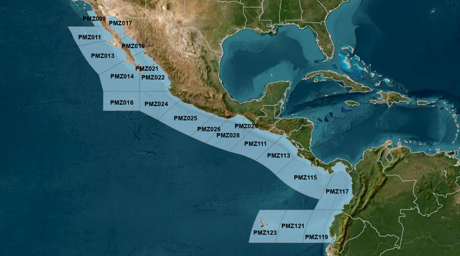
East Pacific within 250 nm of Mexico (OFFPZ7)
000
FZPN27 KNHC 272043
OFFPZ7

Offshore Waters Forecast
National Weather Service National Hurricane Center Miami, FL
143 PM PDT Sat Apr 27 2024

Offshore Waters Forecast for the E Pacific within 250 nm of
Mexico

Seas given as significant wave height, which is the average
height of the highest 1/3 of the waves. Individual waves may be
more than twice the significant wave height.
Synopsis for the E Pacific within 250 nm of Mexico
PMZ001-280845-
Synopsis for the E Pacific within 250 nm of Mexico
143 PM PDT Sat Apr 27 2024

.SYNOPSIS...Strong high pressure will continue across the NE
Pacific to sustain fresh NW winds across the Baja offshore
waters, with locally strong winds this afternoon and evening.
Winds across the Gulf of California are expected to be gentle to
moderate northwesterly over the southern and central Gulf through
Sun night. The high pressure will move east and weaken modestly
Sun through the middle of next week, leading to weakening winds
across the area waters. Moderate NW swell will continue across
the waters to the west of Baja California today, then become
reinforced late in the weekend, with seas building to 8 to 12 ft
across the outer waters of Baja Norte, and gradually shifting
westward and increasing Sun night through Wed.
PMZ009 Zone Forecast
PMZ009-280845-
Mexico Border S to 30N within 60 nm of shore-
143 PM PDT Sat Apr 27 2024

.TONIGHT...N of 31N, NW winds 10 to 15 kt. S of 31N, NW winds
15 to 20 kt, diminishing to 10 to 15 kt late. Seas
8 ft. Period 9 seconds.
.SUN...W to NW winds 10 to 15 kt. Seas 7 ft. Period 9 seconds.
.SUN NIGHT...NW winds 10 to 15 kt. Seas 8 ft. Period 9 seconds.
.MON...W to NW winds 10 kt. Seas 8 ft. Period 10 seconds.
.MON NIGHT...W to NW winds 10 to 15 kt. Seas 4 to 6 ft. Period
11 seconds.
.TUE...S winds 10 kt N of 31N, and variable less than 5 kt S of
31N. Seas 3 to 5 ft. Period 11 seconds.
.TUE NIGHT...SW winds 10 kt N of 31N, and variable less than
5 kt S of 31N. Seas 3 to 5 ft. Period 11 seconds.
.WED...SW winds 10 kt. Seas 4 to 6 ft. Period 11 seconds.
.WED NIGHT...W to NW winds 10 kt. Seas 4 to 6 ft. Period
11 seconds.
.THU...Variable winds less than 5 kt N of 31N, and W to NW 10 kt
S of 31N. Seas 3 to 5 ft. Period 11 seconds.
.THU NIGHT...Variable winds less than 5 kt N of 31N, and NW
10 kt S of 31N. Seas 3 to 5 ft. Period 10 seconds.
Forecaster Hagen
PMZ011 Zone Forecast
PMZ011-280845-
30N to Punta Eugenia within 250 nm of shore-
143 PM PDT Sat Apr 27 2024

.TONIGHT...NW to N winds 15 to 20 kt. Seas 9 ft. Period
9 seconds.
.SUN...NW to N winds 15 to 20 kt. Seas 7 to 8 ft within 60 nm of
the coast, and 9 to 10 ft Elsewhere. Period 9 seconds.
.SUN NIGHT...NW winds 15 to 20 kt. Seas 7 to 8 ft within 60 nm
of the coast, and 10 to 11 ft Elsewhere. Period 9 seconds.
.MON...NW winds 15 to 20 kt. Seas 8 ft within 60 nm of the
coast, and 11 ft Elsewhere. Period 9 seconds.
.MON NIGHT...NW winds 15 to 20 kt. Seas 5 to 7 ft. Period
10 seconds.
.TUE...W to NW winds 10 kt within 60 nm of the coast, and NW
15 to 20 kt Elsewhere. Seas 6 to 8 ft. Period 11 seconds.
.TUE NIGHT...W to NW winds 10 kt within 60 nm of the coast, and
NW 15 to 20 kt Elsewhere. Seas 6 to 8 ft. Period 11 seconds.
.WED...W to NW winds 10 kt within 60 nm of the coast, and NW
15 to 20 kt Elsewhere. Seas 6 to 8 ft. Period 11 seconds.
.WED NIGHT...NW winds 15 to 20 kt. Seas 6 to 8 ft. Period
11 seconds.
.THU...NW winds 10 to 15 kt. Seas 5 to 7 ft. Period 11 seconds.
.THU NIGHT...NW winds 10 to 15 kt. Seas 4 to 6 ft. Period
11 seconds.
Forecaster Hagen
PMZ013 Zone Forecast
PMZ013-280845-
Punta Eugenia to Cabo San Lazaro within 250 nm offshore-
143 PM PDT Sat Apr 27 2024

.TONIGHT...NW to N winds 15 to 20 kt. Seas 8 ft. Period
9 seconds.
.SUN...NW to N winds 10 to 15 kt. Seas 8 ft. Period 9 seconds.
.SUN NIGHT...NW to N winds 15 to 20 kt. Seas 8 ft. Period
12 seconds.
.MON...NW to N winds 10 to 15 kt. Seas 6 to 7 ft Within 60 nm of
shore, and 9 ft Elsewhere. Period 14 seconds.
.MON NIGHT...NW winds 10 to 15 kt. Seas 4 to 6 ft. Period
14 seconds.
.TUE...NW winds 10 to 15 kt. Seas 4 to 6 ft. Period 13 seconds.
.TUE NIGHT...NW winds 10 to 15 kt. Seas 4 to 6 ft. Period
12 seconds.
.WED...NW winds 10 to 15 kt. Seas 4 to 6 ft. Period 11 seconds.
.WED NIGHT...NW winds 10 to 15 kt. Seas 4 to 6 ft. Period
11 seconds.
.THU...NW to N winds 10 to 15 kt. Seas 4 to 6 ft. Period
11 seconds.
.THU NIGHT...NW winds 10 to 15 kt. Seas 4 to 6 ft. Period
11 seconds.
Forecaster Hagen
PMZ014 Zone Forecast
PMZ014-280845-
Cabo San Lazaro to Cabo San Lucas within 350 nm offshore N of
20N-
143 PM PDT Sat Apr 27 2024

.TONIGHT...NW to N winds 15 to 20 kt. Seas 8 ft. Period
8 seconds.
.SUN...NW to N winds 10 to 15 kt. Seas 7 to 8 ft. Period
9 seconds.
.SUN NIGHT...NW to N winds 10 to 15 kt. Seas 6 to 7 ft. Period
15 seconds.
.MON...NW to N winds 10 kt. Seas 6 ft. Period 15 seconds.
.MON NIGHT...NW to N winds 10 kt. Seas 3 to 4 ft. Period
14 seconds.
.TUE...NW to N winds 10 kt. Seas 3 to 4 ft. Period 14 seconds.
.TUE NIGHT...NW winds 10 to 15 kt. Seas 3 to 5 ft. Period
13 seconds.
.WED...NW to N winds 10 to 15 kt. Seas 3 to 5 ft. Period
12 seconds.
.WED NIGHT...NW winds 10 to 15 kt. Seas 3 to 5 ft. Period
12 seconds.
.THU...NW to N winds 10 to 15 kt. Seas 3 to 5 ft. Period
12 seconds.
.THU NIGHT...NW to N winds 10 to 15 kt. Seas 3 to 5 ft. Period
14 seconds.
Forecaster Hagen
PMZ016 Zone Forecast
PMZ016-280845-
From 17N to 20N Between 110W and 115W including the
Revillagigedo Islands-
143 PM PDT Sat Apr 27 2024

.TONIGHT...N winds 15 kt. Seas 7 ft. Period 15 seconds.
.SUN...N winds 10 to 15 kt. Seas 7 ft. Period 9 seconds.
.SUN NIGHT...N winds 10 to 15 kt. Seas 6 to 7 ft. Period
8 seconds.
.MON...N winds 10 kt. Seas 6 ft. Period 13 seconds.
.MON NIGHT...N winds 10 kt. Seas 4 to 6 ft. Period 14 seconds.
.TUE...NW to N winds 10 kt. Seas 4 to 6 ft. Period 14 seconds.
.TUE NIGHT...NW to N winds 10 kt. Seas 4 to 6 ft. Period
13 seconds.
.WED...NW to N winds 10 kt. Seas 4 to 6 ft. Period 12 seconds.
.WED NIGHT...NW to N winds 10 kt. Seas 5 to 6 ft. Period
12 seconds.
.THU...NW to N winds 10 kt. Seas 5 to 7 ft. Period 12 seconds.
.THU NIGHT...N winds 10 kt. Seas 5 to 7 ft. Period 11 seconds.
Forecaster Hagen
PMZ017 Zone Forecast
PMZ017-280845-
Northern Gulf of California-
143 PM PDT Sat Apr 27 2024

.TONIGHT...SW to W winds 10 to 15 kt. Seas 3 ft in the evening,
becoming 2 ft or less. Period 4 seconds.
.SUN...E winds 10 kt, shifting to S to SW in the afternoon.
Seas 2 ft or less. Period 4 seconds.
.SUN NIGHT...N of 30N, variable winds less than 5 kt, becoming S
10 kt late. Elsewhere, SW to W winds 10 kt in the
evening, becoming variable winds less than 5 kt. Seas 2 ft or
less. Period 4 seconds.
.MON...SE to S winds 10 kt. Seas 2 ft or less. Period 6 seconds.
.MON NIGHT...S winds 10 to 15 kt. Seas 2 ft or less. Period
4 seconds.
.TUE...SE to S winds 10 to 15 kt. Seas 2 ft or less. Period
4 seconds.
.TUE NIGHT...S winds 10 to 15 kt. Seas 2 ft or less. Period
5 seconds.
.WED...S winds 10 to 15 kt. Seas 2 ft or less. Period 5 seconds.
.WED NIGHT...S winds 10 to 15 kt. Seas 2 ft or less. Period
4 seconds.
.THU...S winds 10 kt. Seas 2 ft or less. Period 4 seconds.
.THU NIGHT...Variable winds less than 5 kt N of 30N, and W to NW
10 kt Elsewhere. Seas 2 ft or less. Period 13 seconds.
Forecaster Hagen
PMZ019 Zone Forecast
PMZ019-280845-
Central Gulf of California-
143 PM PDT Sat Apr 27 2024

.TONIGHT...NW winds 10 to 15 kt. Seas 3 ft. Period 8 seconds.
.SUN...NW winds 10 to 15 kt. Seas 3 ft. Period 8 seconds.
.SUN NIGHT...W to NW winds 10 kt in the evening, becoming
variable winds less than 5 kt. Seas 3 ft in the evening,
becoming 2 ft or less. Period 15 seconds.
.MON...Variable winds less than 5 kt, becoming S 10 kt in the
afternoon. Seas 2 ft or less. Period 15 seconds.
.MON NIGHT...S winds 10 kt. Seas 2 ft or less. Period
15 seconds.
.TUE...SE to S winds 10 kt. Seas 2 ft or less. Period
14 seconds.
.TUE NIGHT...S winds 10 kt. Seas 2 ft or less. Period
14 seconds.
.WED...S winds 10 kt. Seas 2 ft or less. Period 14 seconds.
.WED NIGHT...S to SW winds 10 to 15 kt. Seas 2 ft or less.
Period 18 seconds.
.THU...S to SW winds 10 kt. Seas 2 ft or less. Period
18 seconds.
.THU NIGHT...Variable winds less than 5 kt. Seas 2 ft or less.
Period 17 seconds.
Forecaster Hagen
PMZ021 Zone Forecast
PMZ021-280845-
Southern Gulf of California-
143 PM PDT Sat Apr 27 2024

.TONIGHT...NW winds 10 to 15 kt. Seas 3 to 4 ft. Period
17 seconds.
.SUN...NW winds 10 to 15 kt. Seas 4 ft. Period 16 seconds.
.SUN NIGHT...NW winds 10 kt. Seas 4 ft. Period 16 seconds.
.MON...W to NW winds 10 kt. Seas 3 ft. Period 15 seconds.
.MON NIGHT...SW winds 10 to 15 kt. Seas 2 ft or less. Period
15 seconds.
.TUE...S winds 10 kt. Seas 2 ft or less. Period 14 seconds.
.TUE NIGHT...S winds 10 to 15 kt. Seas 2 ft or less. Period
14 seconds.
.WED...S winds 10 kt. Seas 2 ft or less. Period 18 seconds.
.WED NIGHT...S to SW winds 10 to 15 kt. Seas 2 ft or less.
Period 18 seconds.
.THU...W winds 10 kt. Seas 2 ft or less. Period 17 seconds.
.THU NIGHT...W winds 10 kt. Seas 2 ft or less. Period
16 seconds.
Forecaster Hagen
PMZ022 Zone Forecast
PMZ022-280845-
N of 20N E of 110W to the Entrance of the Gulf of California-
143 PM PDT Sat Apr 27 2024

.TONIGHT...NW to N winds 10 to 15 kt. Seas 7 ft. Period
16 seconds.
.SUN...NW to N winds 10 to 15 kt. Seas 7 ft. Period 16 seconds.
.SUN NIGHT...NW winds 10 to 15 kt. Seas 6 ft. Period 15 seconds.
.MON...NW winds 10 kt. Seas 6 ft. Period 15 seconds.
.MON NIGHT...NW winds 10 kt. Seas 3 ft. Period 14 seconds.
.TUE...W to NW winds 10 kt. Seas 3 ft. Period 14 seconds.
.TUE NIGHT...W to NW winds 10 to 15 kt. Seas 3 ft. Period
14 seconds.
.WED...W to NW winds 10 to 15 kt. Seas 3 to 4 ft. Period
17 seconds.
.WED NIGHT...W to NW winds 10 to 15 kt. Seas 3 to 4 ft. Period
17 seconds.
.THU...W to NW winds 10 to 15 kt. Seas 3 to 4 ft. Period
16 seconds.
.THU NIGHT...NW winds 10 to 15 kt. Seas 3 to 4 ft. Period
15 seconds.
Forecaster Hagen
PMZ024 Zone Forecast
PMZ024-280845-
Colima and Jalisco within 300 nm offshore S of 20N and E of
110W-
143 PM PDT Sat Apr 27 2024

.TONIGHT...NW to N winds 15 to 20 kt, diminishing to 10 to 15 kt
late. Seas 7 ft. Period 16 seconds.
.SUN...NW to N winds 10 to 15 kt. Seas 7 ft. Period 15 seconds.
.SUN NIGHT...NW to N winds 10 to 15 kt. Seas 6 ft. Period
15 seconds.
.MON...NW to N winds 10 kt. Seas 6 ft. Period 15 seconds.
.MON NIGHT...NW to N winds 10 to 15 kt. Seas 3 ft. Period
14 seconds.
.TUE...NW to N winds 10 kt. Seas 3 ft. Period 14 seconds.
.TUE NIGHT...NW winds 10 to 15 kt. Seas 3 ft. Period 14 seconds.
.WED...NW to N winds 10 kt. Seas 3 ft. Period 16 seconds.
.WED NIGHT...NW winds 10 to 15 kt. Seas 3 to 4 ft. Period
16 seconds.
.THU...NW to N winds 10 kt. Seas 3 to 4 ft. Period 15 seconds.
.THU NIGHT...NW winds 10 to 15 kt. Seas 3 to 4 ft. Period
15 seconds.
Forecaster Hagen
PMZ025 Zone Forecast
PMZ025-280845-
Michoacan and Guerrero within 250 nm offshore-
143 PM PDT Sat Apr 27 2024

.TONIGHT...NW winds 10 to 15 kt. Seas 6 ft. Period 16 seconds.
.SUN...Within 60 nm of shore, variable winds less than 5 kt,
becoming SW to W 10 kt in the afternoon. Elsewhere, NW winds
10 kt. Seas 6 ft. Period 16 seconds.
.SUN NIGHT...NW winds 10 kt. Seas 5 to 6 ft. Period 15 seconds.
.MON...Within 60 nm of shore, variable winds less than 5 kt,
becoming W 10 kt in the afternoon. Elsewhere, NW to N winds
10 kt. Seas 5 ft. Period 15 seconds.
.MON NIGHT...NW winds 10 kt. Seas 3 ft. Period 14 seconds.
.TUE...Variable winds less than 5 kt. Seas 3 ft. Period
14 seconds.
.TUE NIGHT...NW winds 10 kt. Seas 3 ft. Period 17 seconds.
.WED...NW winds 10 kt. Seas 3 ft. Period 17 seconds.
.WED NIGHT...NW winds 10 kt. Seas 3 ft. Period 16 seconds.
.THU...NW winds 10 kt. Seas 3 ft. Period 15 seconds.
.THU NIGHT...NW winds 10 to 15 kt. Seas 3 to 4 ft. Period
15 seconds.
Forecaster Hagen
PMZ026 Zone Forecast
PMZ026-280845-
Oaxaca W of Puerto Angel within 250 nm offshore-
143 PM PDT Sat Apr 27 2024

.TONIGHT...W winds 10 kt. Seas 5 ft. Period 16 seconds.
.SUN...W winds 10 kt. Seas 5 ft. Period 16 seconds.
.SUN NIGHT...W winds 10 kt. Seas 5 ft. Period 15 seconds.
.MON...Variable winds less than 5 kt, becoming W to NW 10 kt in
the afternoon. Seas 5 ft. Period 15 seconds.
.MON NIGHT...Variable winds less than 5 kt. Seas 3 ft. Period
14 seconds.
.TUE...NW winds 10 kt. Seas 3 ft. Period 15 seconds.
.TUE NIGHT...Variable winds less than 5 kt. Seas 3 ft. Period
16 seconds.
.WED...NW winds 10 kt. Seas 3 ft. Period 16 seconds.
.WED NIGHT...NW winds 10 kt. Seas 3 ft. Period 16 seconds.
.THU...NW winds 10 kt. Seas 3 ft. Period 15 seconds.
.THU NIGHT...W to NW winds 10 kt. Seas 3 ft. Period 14 seconds.
Forecaster Hagen
PMZ028 Zone Forecast
PMZ028-280845-
Oaxaca E of Puerto Angel within 300 nm offshore including the
Gulf of Tehuantepec-
143 PM PDT Sat Apr 27 2024

.TONIGHT...SW to W winds 10 to 15 kt N of 14N, and variable less
than 5 kt S of 14N. Seas 5 ft. Period 16 seconds.
.SUN...SW to W winds 10 to 15 kt N of 14N, and variable less
than 5 kt S of 14N. Seas 5 ft. Period 16 seconds.
.SUN NIGHT...SW to W winds 10 kt N of 14N, and variable less
than 5 kt S of 14N. Seas 5 ft. Period 15 seconds.
.MON...SW to W winds 10 kt N of 14N, and variable less than 5 kt
S of 14N. Seas 5 ft. Period 15 seconds.
.MON NIGHT...SW to W winds 10 kt N of 14N, and variable less
than 5 kt S of 14N. Seas 3 ft. Period 14 seconds.
.TUE...Variable winds less than 5 kt. Seas 3 ft. Period
16 seconds.
.TUE NIGHT...W winds 10 kt N of 14N, and variable less than 5 kt
S of 14N. Seas 3 ft. Period 17 seconds.
.WED...W winds 10 kt N of 14N, and variable less than 5 kt S of
14N. Seas 3 ft. Period 17 seconds.
.WED NIGHT...SW to W winds 10 kt N of 14N, and variable less
than 5 kt S of 14N. Seas 3 ft. Period 16 seconds.
.THU...SW to W winds 10 kt N of 14N, and variable less than 5 kt
S of 14N. Seas 3 ft. Period 15 seconds.
.THU NIGHT...SW to W winds 10 kt N of 14N, and variable less
than 5 kt S of 14N. Seas 3 ft. Period 14 seconds.
Forecaster Hagen
PMZ029 Zone Forecast
PMZ029-280845-
Offshore Chiapas E of 94W-
143 PM PDT Sat Apr 27 2024

.TONIGHT...Variable winds less than 5 kt. Seas 4 ft. Period
16 seconds.
.SUN...Variable winds less than 5 kt, becoming W 10 kt in the
afternoon. Seas 4 ft. Period 16 seconds.
.SUN NIGHT...Variable winds less than 5 kt. Seas 4 ft. Period
15 seconds.
.MON...Variable winds less than 5 kt, becoming SW to W 10 kt in
the afternoon. Seas 4 ft. Period 15 seconds.
.MON NIGHT...Variable winds less than 5 kt. Seas 2 ft or less.
Period 14 seconds.
.TUE...Variable winds less than 5 kt. Seas 2 ft or less. Period
14 seconds.
.TUE NIGHT...Variable winds less than 5 kt. Seas 3 ft. Period
17 seconds.
.WED...Variable winds less than 5 kt. Seas 3 ft. Period
17 seconds.
.WED NIGHT...Variable winds less than 5 kt. Seas 3 ft. Period
16 seconds.
.THU...W to NW winds 10 kt E of 93W, and variable less than 5 kt
W of 93W. Seas 3 ft. Period 15 seconds.
.THU NIGHT...Variable winds less than 5 kt. Seas 3 ft. Period
14 seconds.
Forecaster Hagen
East Pacific offshore of Central America, Colombia, & Ecuador (OFFPZ8)
190
FZPN28 KNHC 272044
OFFPZ8

Offshore Waters Forecast
NWS National Hurricane Center Miami, FL
144 PM PDT Sat Apr 27 2024

Offshore Waters Forecast for the E Pacific within 250 nm of
Central America, Colombia, and within 750 nm of Ecuador

Seas given as significant wave height, which is the average
height of the highest 1/3 of the waves. Individual waves may be
more than twice the significant wave height.
Synopsis for the E Pacific within 250 nm of Central America, Colombia, and within 750 nm of Ecuador
PMZ101-280845-
Synopsis for the E Pacific within 250 nm of Central America,
Colombia, and within 750 nm of Ecuador
144 PM PDT Sat Apr 27 2024

.SYNOPSIS...Winds across the Papagayo region will remain
moderate or weaker for the next several days. Gentle to moderate
winds with moderate seas will prevail elsewhere through Mon
before new S swell raises seas slightly across the regional
waters Mon night and Tue. Looking ahead, a more significant S
swell is expected across the region late in the week.
PMZ111 Zone Forecast
PMZ111-280845-
Guatemala and El Salvador to 250 nm offshore-
144 PM PDT Sat Apr 27 2024

.TONIGHT...S winds 10 kt, shifting to N late. Seas
3 to 5 ft. Period 16 seconds.
.SUN...NE to E winds 10 to 15 kt. Seas 3 to 5 ft. Period
16 seconds.
.SUN NIGHT...E to SE winds 10 kt in the evening, becoming
variable winds less than 5 kt. Seas 3 to 5 ft in S to SW swell.
Period 15 seconds.
.MON...NE to E winds 10 kt. Seas 3 to 5 ft. Period 15 seconds.
.MON NIGHT...NE to E winds 10 kt. Seas 3 to 5 ft. Period
14 seconds.
.TUE...E winds 10 kt. Seas 3 to 5 ft. Period 15 seconds.
.TUE NIGHT...E to SE winds 10 kt. Seas 3 to 5 ft. Period
16 seconds.
.WED...E winds 10 kt. Seas 3 to 5 ft. Period 15 seconds.
.WED NIGHT...SE to S winds 10 kt. Seas 3 to 5 ft. Period
14 seconds.
.THU...Variable winds less than 5 kt. Seas 3 to 5 ft in S swell.
Period 14 seconds.
.THU NIGHT...Variable winds less than 5 kt. Seas 3 to 5 ft in S
swell. Period 13 seconds.
Forecaster Hagen
PMZ113 Zone Forecast
PMZ113-280845-
El Salvador to North Costa Rica including the Gulfs of Fonseca
and Papagayo-
144 PM PDT Sat Apr 27 2024

.TONIGHT...S winds 10 kt. Seas 4 to 6 ft in S to SW swell.
Period 16 seconds. Scattered showers through the night.
.SUN...E winds 10 kt, shifting to SE to S in the afternoon.
Seas 4 to 6 ft in S to SW swell. Period 16 seconds. Scattered
tstms through the day.
.SUN NIGHT...S winds 10 kt. Seas 3 to 5 ft. Period 15 seconds.
Scattered showers through the night.
.MON...SE to S winds 10 kt. Seas 3 to 5 ft. Period 15 seconds.
Scattered showers through the day.
.MON NIGHT...S to SW winds 10 kt. Seas 3 to 5 ft. Period
14 seconds.
.TUE...SE winds 10 kt. Seas 3 to 5 ft. Period 15 seconds.
.TUE NIGHT...S to SW winds 10 kt. Seas 3 to 5 ft. Period
16 seconds.
.WED...S winds 10 kt. Seas 3 to 5 ft. Period 15 seconds.
.WED NIGHT...SW to W winds 10 kt. Seas 3 to 5 ft. Period
14 seconds.
.THU...Variable winds less than 5 kt Offshore Gulf of Papagayo,
and W 10 kt Elsewhere. Seas 3 to 5 ft. Period 14 seconds.
.THU NIGHT...SW to W winds 10 kt. Seas 3 to 5 ft. Period
13 seconds.
Forecaster Hagen
PMZ115 Zone Forecast
PMZ115-280845-
North Costa Rica to West Panama to 250 nm offshore-
144 PM PDT Sat Apr 27 2024

.TONIGHT...SW to W winds 10 to 15 kt. Seas 4 to 6 ft. Period
16 seconds. Numerous showers and scattered tstms.
.SUN...SW winds 10 kt. Seas 4 to 6 ft in S to SW swell. Period
16 seconds. Scattered tstms through the day.
.SUN NIGHT...SW to W winds 10 kt. Seas 3 to 5 ft. Period
15 seconds. Scattered showers and isolated tstms through the
night.
.MON...SW winds 10 kt. Seas 3 to 5 ft. Period 14 seconds.
Scattered tstms through the day.
.MON NIGHT...Variable winds less than 5 kt Near the Azuero
Peninsula, and SW to W 10 kt Elsewhere. Seas 3 to 5 ft. Period
15 seconds.
.TUE...Variable winds less than 5 kt. Seas 3 to 5 ft in S to SW
swell. Period 16 seconds.
.TUE NIGHT...Variable winds less than 5 kt Near the Azuero
Peninsula, and SW to W 10 kt Elsewhere. Seas 4 to 6 ft in S
swell. Period 16 seconds.
.WED...Variable winds less than 5 kt Near the Azuero Peninsula,
and SW to W 10 kt Elsewhere. Seas 4 to 6 ft in S swell. Period
15 seconds.
.WED NIGHT...W winds 10 kt. Seas 3 to 5 ft. Period 14 seconds.
.THU...Variable winds less than 5 kt Near the Azuero Peninsula,
and W 10 kt Elsewhere. Seas 3 to 5 ft. Period 13 seconds.
.THU NIGHT...Variable winds less than 5 kt Near the Azuero
Peninsula, and W 10 kt Elsewhere. Seas 3 to 5 ft. Period
15 seconds.
Forecaster Hagen
PMZ117 Zone Forecast
PMZ117-280845-
East Panama and Colombia including the Gulf of Panama-
144 PM PDT Sat Apr 27 2024

.TONIGHT...SW to W winds 10 to 15 kt. Seas 4 to 6 ft. Period
16 seconds. Scattered showers and isolated tstms through the
night.
.SUN...SW winds 10 kt. Seas 4 to 6 ft in S to SW swell. Period
16 seconds. Scattered showers and isolated tstms through the
day.
.SUN NIGHT...SW winds 10 kt. Seas 3 to 5 ft. Period 15 seconds.
Scattered tstms through the night.
.MON...SW to W winds 10 kt. Seas 3 to 5 ft. Period 15 seconds.
Scattered tstms through the day.
.MON NIGHT...Variable winds less than 5 kt. Seas 3 to 5 ft in S
to SW swell. Period 15 seconds.
.TUE...Variable winds less than 5 kt. Seas 3 to 5 ft in S to SW
swell. Period 15 seconds.
.TUE NIGHT...Variable winds less than 5 kt. Seas 4 to 6 ft in S
to SW swell. Period 14 seconds.
.WED...Variable winds less than 5 kt Gulf of Panama, and SW to W
10 kt Elsewhere. Seas 4 to 6 ft in S to SW swell. Period
14 seconds.
.WED NIGHT...SW to W winds 10 kt. Seas 4 to 6 ft in S to SW
swell. Period 13 seconds.
.THU...Variable winds less than 5 kt Gulf of Panama, and SW
10 kt Elsewhere. Seas 4 to 6 ft in S to SW swell. Period
13 seconds.
.THU NIGHT...SW winds 10 kt. Seas 4 to 6 ft in S to SW swell.
Period 14 seconds.
Forecaster Hagen
PMZ119 Zone Forecast
PMZ119-280845-
Ecuador including the Gulf of Guayaquil to 250 nm offshore-
144 PM PDT Sat Apr 27 2024

.TONIGHT...S to SW winds 10 to 15 kt. Seas 4 to 6 ft. Period
15 seconds.
.SUN...Gulf of Guayaquil, variable winds less than 5 kt,
becoming W 10 kt in the afternoon. Elsewhere, S to SW winds
10 kt. Seas 3 to 5 ft. Period 15 seconds.
.SUN NIGHT...Variable winds less than 5 kt Gulf of Guayaquil,
and S to SW 10 kt Elsewhere. Seas 3 to 5 ft. Period 15 seconds.
.MON...Gulf of Guayaquil, variable winds less than 5 kt,
becoming SW to W 10 kt in the afternoon. Elsewhere, S winds
10 kt in the morning, becoming variable winds less than 5 kt.
Seas 4 to 6 ft. Period 17 seconds.
.MON NIGHT...Variable winds less than 5 kt. Seas 4 to 6 ft in S
to SW swell. Period 15 seconds.
.TUE...S to SW winds 10 kt. Seas 4 to 6 ft in S to SW swell.
Period 15 seconds.
.TUE NIGHT...S to SW winds 10 kt. Seas 4 to 6 ft in S to SW
swell. Period 14 seconds.
.WED...S to SW winds 10 kt. Seas 4 to 6 ft in S to SW swell.
Period 13 seconds.
.WED NIGHT...S to SW winds 10 kt. Seas 4 to 6 ft in S to SW
swell. Period 13 seconds.
.THU...S to SW winds 10 kt. Seas 4 to 6 ft in S to SW swell.
Period 15 seconds.
.THU NIGHT...S to SW winds 10 kt. Seas 5 to 7 ft in S swell.
Period 16 seconds.
Forecaster Hagen
PMZ121 Zone Forecast
PMZ121-280845-
Ecuador between 250 and 500 nm offshore-
144 PM PDT Sat Apr 27 2024

.TONIGHT...S to SW winds 10 kt. Seas 4 to 6 ft in S to SW swell.
Period 15 seconds.
.SUN...SE to S winds 10 kt. Seas 3 to 5 ft. Period 15 seconds.
.SUN NIGHT...SE to S winds 10 kt. Seas 3 to 5 ft. Period
14 seconds.
.MON...SE winds 10 kt in the morning, becoming variable winds
less than 5 kt. Seas 4 to 6 ft in S to SW swell. Period
17 seconds.
.MON NIGHT...Variable winds less than 5 kt. Seas 4 to 6 ft in S
swell. Period 16 seconds.
.TUE...SE to S winds 10 kt. Seas 4 to 6 ft in S swell. Period
15 seconds.
.TUE NIGHT...SE to S winds 10 kt. Seas 4 to 6 ft in S swell.
Period 14 seconds.
.WED...SE to S winds 10 kt. Seas 4 to 6 ft in S swell. Period
13 seconds.
.WED NIGHT...SE to S winds 10 kt. Seas 4 to 6 ft in S swell.
Period 14 seconds.
.THU...SE to S winds 10 kt. Seas 4 to 6 ft in S swell. Period
15 seconds.
.THU NIGHT...SE to S winds 10 kt. Seas 5 to 7 ft in S swell.
Period 16 seconds.
Forecaster Hagen
PMZ123 Zone Forecast
PMZ123-280845-
Offshore Galapagos Islands-
144 PM PDT Sat Apr 27 2024

.TONIGHT...S to SW winds 10 kt. Seas 3 to 5 ft. Period
15 seconds.
.SUN...S winds 10 kt. Seas 3 to 5 ft. Period 14 seconds.
.SUN NIGHT...S winds 10 kt. Seas 3 to 5 ft. Period 14 seconds.
.MON...SE to S winds 10 kt in the morning, becoming variable
winds less than 5 kt. Seas 4 to 6 ft in S swell. Period
17 seconds.
.MON NIGHT...Variable winds less than 5 kt. Seas 4 to 6 ft in S
swell. Period 16 seconds.
.TUE...SE winds 10 kt. Seas 4 to 6 ft in S swell. Period
15 seconds.
.TUE NIGHT...SE winds 10 kt. Seas 4 to 6 ft in S swell. Period
14 seconds.
.WED...SE winds 10 kt. Seas 4 to 6 ft in S swell. Period
13 seconds.
.WED NIGHT...SE winds 10 kt. Seas 4 to 6 ft in S swell. Period
15 seconds.
.THU...SE winds 10 kt. Seas 4 to 6 ft in S swell. Period
15 seconds.
.THU NIGHT...SE winds 10 kt. Seas 5 to 7 ft in S swell. Period
16 seconds.
Forecaster Hagen
Tropical North Atlantic High Seas (HSFAT2)
000
FZNT02 KNHC 271935
HSFAT2

HIGH SEAS FORECAST
NWS NATIONAL HURRICANE CENTER MIAMI FL
2230 UTC SAT APR 27 2024

SUPERSEDED BY NEXT ISSUANCE IN 6 HOURS

SEAS GIVEN AS SIGNIFICANT WAVE HEIGHT...WHICH IS THE AVERAGE
HEIGHT OF THE HIGHEST 1/3 OF THE WAVES. INDIVIDUAL WAVES MAY BE
MORE THAN TWICE THE SIGNIFICANT WAVE HEIGHT.

SECURITE

ATLANTIC FROM 07N TO 31N W OF 35W INCLUDING CARIBBEAN SEA AND
GULF OF MEXICO

SYNOPSIS VALID 1800 UTC SAT APR 27.
24 HOUR FORECAST VALID 1800 UTC SUN APR 28.
48 HOUR FORECAST VALID 1800 UTC MON APR 29.

.WARNINGS.

...ATLC GALE WARNING...
.ATLC AND GULF OF MEXICO WITHIN 26N80W TO 25N80W TO 25N81W TO
24N81W TO 24N80W TO 24N79W TO 26N80W...INCLUDING STRAITS OF
FLORIDA... E WINDS 20 TO 25 KT. SEAS 8 FT.
.03 HOUR FORECAST WITHIN 27N79W TO 27N80W TO 25N80W TO 25N79W TO
27N79W E WINDS 20 TO 30 KT WITH FREQUENT GUSTS TO GALE FORCE.
SEAS 8 FT. ELSEWHERE WITHIN 25N79W TO 28N80W TO 25N81W TO 25N83W
TO 23N83W TO 23N80W TO 25N79W...INCLUDING STRAITS OF FLORIDA...
E WINDS 20 TO 25 KT. SEAS 8 FT.
.21 HOUR FORECAST CONDITIONS IMPROVE. WINDS 20 KT OR LESS. SEAS
LESS THAN 8 FT.

.SYNOPSIS AND FORECAST.

.ATLC WITHIN 31N61W TO 31N74W TO 28N73W TO 27N71W TO 29N67W TO
31N61W NE WINDS 20 TO 25 KT. SEAS 8 TO 9 FT.

.24 HOUR FORECAST WITHIN 31N42W TO 31N47W TO 30N46W TO 29N45W TO
29N44W TO 30N42W TO 31N42W S WINDS 20 TO 25 KT. SEAS 8 FT.
WITHIN 31N54W TO 31N61W TO 29N61W TO 29N59W TO 29N57W TO 31N54W
NW WINDS 20 TO 25 KT. SEAS 10 TO 12 FT. ELSEWHERE WITHIN 31N51W
TO 31N68W TO 27N75W TO 23N74W TO 21N69W TO 27N55W TO
31N51W...INCLUDING ATLANTIC EXPOSURES...WINDS 20 KT OR LESS.
SEAS 8 TO 10 FT IN NE SWELL.
.48 HOUR FORECAST WITHIN 31N48W TO 31N66W TO 27N66W TO 22N70W TO
20N60W TO 31N48W WINDS 20 KT OR LESS. SEAS 8 TO 10 FT IN N SWELL.

.ATLC AND CARIBBEAN WITHIN 20N72W TO 21N74W TO 20N74W TO 20N76W
TO 19N76W TO 19N73W TO 20N72W...INCLUDING BETWEEN CUBA AND
JAMAICA... NE WINDS 20 TO 25 KT. SEAS LESS THAN 8 FT.
.24 HOUR FORECAST WITHIN 21N73W TO 21N75W TO 19N75W TO 19N74W TO
20N73W TO 20N71W TO 21N73W NE TO E WINDS 20 TO 25 KT. SEAS LESS
THAN 8 FT.
.48 HOUR FORECAST WITHIN 21N73W TO 21N74W TO 20N74W TO 20N73W TO
20N72W TO 21N73W NE TO E WINDS 20 TO 25 KT. SEAS LESS THAN 8 FT.

.CARIBBEAN 06 HOUR FORECAST WITHIN 17N85W TO 18N86W TO 17N87W TO
16N87W TO 17N86W TO 16N85W TO 17N85W...INCLUDING THE GULF OF
HONDURAS... E WINDS 20 TO 25 KT. SEAS LESS THAN 8 FT.
.18 HOUR FORECAST CONDITIONS IMPROVE. WINDS 20 KT OR LESS. SEAS
LESS THAN 8 FT.
.24 HOUR FORECAST WITHIN 17N85W TO 18N86W TO 17N87W TO 16N87W TO
17N86W TO 16N85W TO 17N85W...INCLUDING THE GULF OF HONDURAS... E
WINDS 20 TO 25 KT. SEAS LESS THAN 8 FT.
.48 HOUR FORECAST CONDITIONS IMPROVE. WINDS 20 KT OR LESS. SEAS
LESS THAN 8 FT.

.CARIBBEAN 06 HOUR FORECAST WITHIN 21N77W TO 21N78W TO 22N80W TO
20N80W TO 19N78W TO 20N77W TO 21N77W NE TO E WINDS 20 TO 25 KT.
SEAS LESS THAN 8 FT.
.24 HOUR FORECAST CONDITIONS IMPROVE. WINDS 20 KT OR LESS. SEAS
LESS THAN 8 FT.

.CARIBBEAN 06 HOUR FORECAST WITHIN 18N70W TO 18N71W TO 18N72W TO
17N71W TO 17N70W TO 18N70W NE TO E WINDS 20 TO 25 KT. SEAS LESS
THAN 8 FT.
.24 HOUR FORECAST CONDITIONS IMPROVE. WINDS 20 KT OR LESS. SEAS
LESS THAN 8 FT.

.GULF OF MEXICO WITHIN 28N89W TO 30N92W TO 28N97W TO 25N97W TO
21N95W TO 25N89W TO 28N89W SE WINDS 20 TO 25 KT. SEAS 8 TO 10 FT.
.24 HOUR FORECAST WITHIN 30N86W TO 29N95W TO 26N97W TO 22N95W TO
25N84W TO 30N86W SE WINDS 20 TO 25 KT. SEAS 8 TO 10 FT.
.48 HOUR FORECAST WITHIN 26N92W TO 26N94W TO 24N95W TO 23N94W TO
24N92W TO 24N91W TO 26N92W WINDS 20 KT OR LESS. SEAS 8 FT IN SE
SWELL.

.REMAINDER OF AREA WINDS 20 KT OR LESS. SEAS LESS THAN 8 FT.

$$
.FORECASTER AL. NATIONAL HURRICANE CENTER.
Tropical Northeast Pacific High Seas (HSFEP2)
701
FZPN03 KNHC 272100
HSFEP2

HIGH SEAS FORECAST
NWS NATIONAL HURRICANE CENTER MIAMI FL
2230 UTC SAT APR 27 2024

SUPERSEDED BY NEXT ISSUANCE IN 6 HOURS

SEAS GIVEN AS SIGNIFICANT WAVE HEIGHT...WHICH IS THE AVERAGE
HEIGHT OF THE HIGHEST 1/3 OF THE WAVES. INDIVIDUAL WAVES MAY BE
MORE THAN TWICE THE SIGNIFICANT WAVE HEIGHT.

SECURITE

E PACIFIC FROM THE EQUATOR TO 30N E OF 140W AND 03.4S TO THE
EQUATOR E OF 120W

SYNOPSIS VALID 1800 UTC SAT APR 27.
24 HOUR FORECAST VALID 1800 UTC SUN APR 28.
48 HOUR FORECAST VALID 1800 UTC MON APR 29.

.WARNINGS.

.NONE.

.SYNOPSIS AND FORECAST.

.WITHIN 29N114W TO 30N116W TO 27N115W TO 26N114W TO 26N112W TO
29N114W...INCLUDING SEBASTIAN VIZCAINO BAY AND WITHIN 60 NM OF
SHORE...NW WINDS 20 TO 25 KT. SEAS TO 8 FT. WITHIN 30N116W TO
30N123W TO 28N120W TO 28N116W TO 30N116W WINDS 20 KT OR LESS.
SEAS 8 TO 9 FT IN NW TO N SWELL.
.24 HOUR FORECAST WITHIN 30N117W TO 30N126W TO 26N121W TO
26N118W TO 30N117W WINDS 20 KT OR LESS. SEAS 8 TO 10 FT IN NW TO
N SWELL.
.48 HOUR FORECAST WITHIN 30N119W TO 30N124W TO 28N123W TO
28N120W TO 30N119W NW TO N WINDS 20 TO 25 KT. SEAS 9 TO 11 FT.
ELSEWHERE WITHIN 30N117W TO 30N127W TO 25N128W TO 24N126W TO
24N119W TO 26N117W TO 30N117W WINDS 20 KT OR LESS. SEAS 8 TO 10
FT IN N SWELL.

.WITHIN 14N128W TO 21N140W TO 07N140W TO 10N133W TO 14N128W NE
TO E WINDS 20 TO 25 KT. SEAS 8 TO 10 FT. ELSEWHERE WITHIN
13N119W TO 23N140W TO 05N140W TO 09N121W TO 13N119W WINDS 20 KT
OR LESS. SEAS 8 TO 9 FT IN NE SWELL.
.24 HOUR FORECAST WITHIN 19N130W TO 23N140W TO 04N140W TO
10N121W TO 19N130W WINDS 20 KT OR LESS. SEAS 8 TO 10 FT IN NE TO
E SWELL.
.48 HOUR FORECAST LITTLE CHANGE.

.REMAINDER OF AREA WINDS 20 KT OR LESS. SEAS LESS THAN 8 FT.

CONVECTION VALID AT 2030 UTC SAT APR 27...

.INTERTROPICAL CONVERGENCE ZONE/MONSOON TROUGH...
EQUATORIAL TROUGH FROM 10N85W TO LOW PRES NEAR 07N93W 1011 MB TO
08.5N108W. ITCZ FROM 08.5N108W TO 07.5N120W TO 04.5N140W.
SCATTERED MODERATE ISOLATED STRONG FROM 02N TO 10N BETWEEN 77W
AND 100W...AND FROM 05N TO 11N BETWEEN 111W AND 140W.

$$
.FORECASTER HAGEN. NATIONAL HURRICANE CENTER.