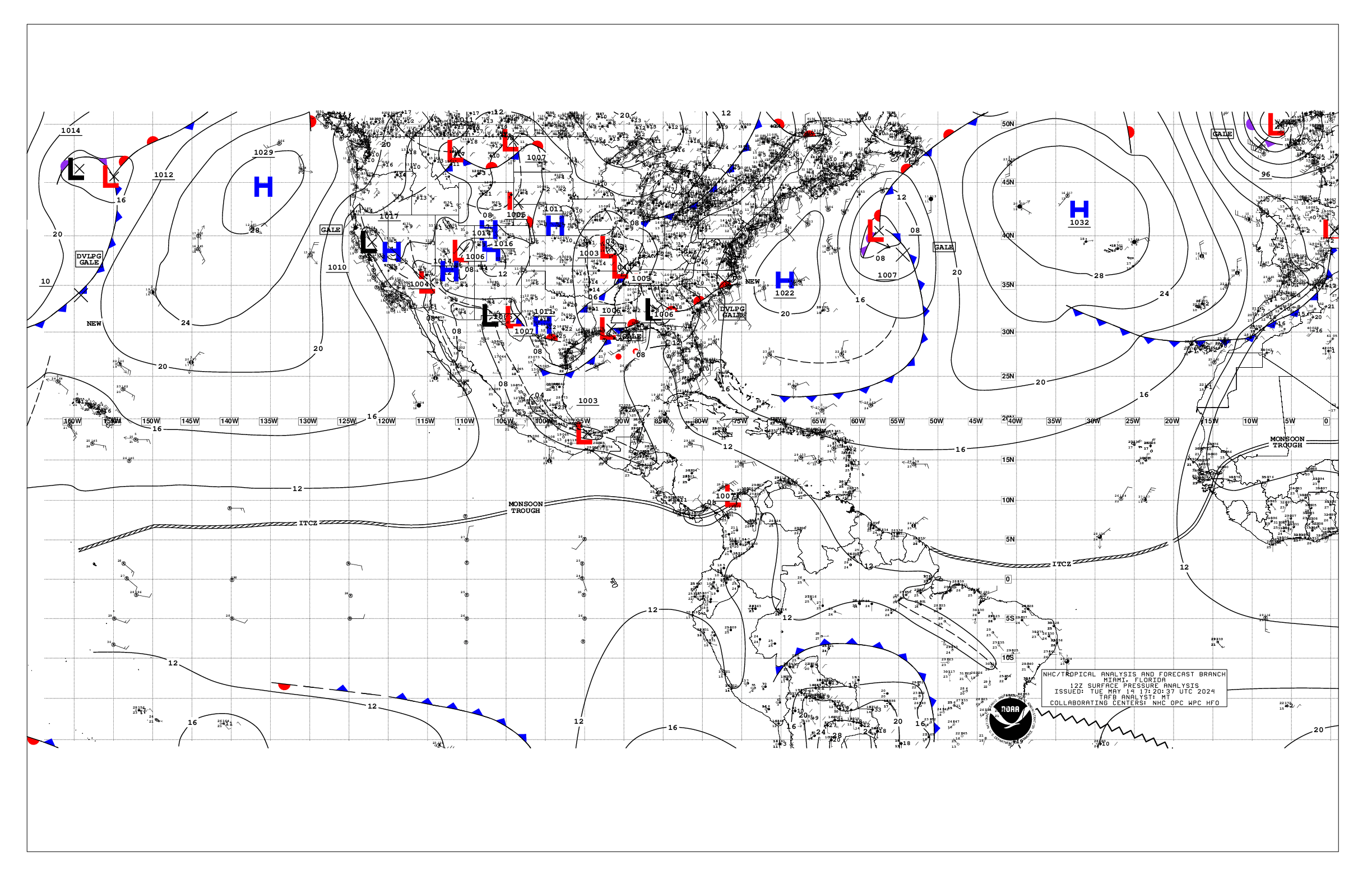
000
AXNT20 KNHC 141816
TWDAT

Tropical Weather Discussion
NWS National Hurricane Center Miami FL
1805 UTC Tue May 14 2024

Tropical Weather Discussion for North America, Central America
Gulf of Mexico, Caribbean Sea, northern sections of South
America, and Atlantic Ocean to the African coast from the
Equator to 31N. The following information is based on satellite
imagery, weather observations, radar and meteorological analysis.

Based on 1200 UTC surface analysis and satellite imagery through
1715 UTC.

...SPECIAL FEATURES...

...GUSTS TO GALE-FORCE IN THE NORTH CENTRAL GULF OF MEXICO...

Frequent gusts to gale-force, and sea heights reaching 8 feet,
have been in the north central coastal waters of the Gulf of
Mexico, since the early morning hours of today. The current
forecast consists of the gusts to gale-force to be weakening,
and the wind speeds slowing down, and the conditions to be
improving, during the early hours of this afternoon. A cold front
passes through the south central coast of Louisiana, to the coast
of NE Mexico just to the south of the Deep South of Texas. A
squall line is along 25N95W 28N90W 28N83W. Precipitation:
scattered moderate to widely scattered strong is from 25N
northward between 85W and 92W.

Please, read the latest High Seas Forecast, that is issued by
the National Hurricane Center, at
http://www.nhc.noaa.gov/text/MIAHSFAT2.shtml, for details.

...MONSOON TROUGH/ITCZ...

The monsoon trough passes through the coastal plains of Guinea-
Bissau near 11N15W, to 05N20W. The ITCZ continues from 05N20W, to
03N30W 02N40W, to 04N51W close to the coast of Brazil and French
Guiana. Precipitation: scattered to numerous strong is from 04N to
07N between 18W and 21W. Widely scattered moderate to isolated
strong is from 07N southward between 21W and 31W. Isolated
moderate to locally strong is in the remainder of the area that is
from 10N southward from 60W eastward.

...GULF OF MEXICO...

Please, read the SPECIAL FEATURES section, for details about the
situation with the gusts to gale-force in the north central Gulf
coastal waters.

A NW-to-SE oriented inland Mexico surface trough passes through
21N100W, to a 1003 mb low pressure center that is near 18N95W,
through northern Guatemala into eastern Honduras. No significant
deep convective precipitation is apparent in the satellite
imagery.

Moderate seas are between the Florida Panhandle and 93W, leading
into the Yucatan Channel. Slight seas are in the remainder of the
Gulf of Mexico. Moderate to fresh winds are in the rest of the Gulf
of Mexico, away from the cold front and the squall line and the
areas of precipitation.

Hazy conditions are in the western sections and in the SW corner
of the Gulf of Mexico. Agricultural fires are in in SE Mexico and
in other parts of Central America.

A cold front is noted from the Sabine River to the Rio Grande,
with a stationary front extending just along the northern Gulf
coast from Louisiana to the Florida Panhandle. To the SE of these
features, as surface trough extends from just offshore the Florida
Big Bend to just N of Tampico, Mexico. For waters near and NW of
the trough, several squall lines exist within a broader area of
strong thunderstorms. These thunderstorms could bring strong to
temporary gale force winds and rough seas. The front will linger
across the northern Gulf over the next few days. This will cause
heavy rain and thunderstorms over the northern basin through Wed.
Meanwhile, moderate to fresh return flow will dominate the basin,
pulsing to strong near the Yucatan Peninsula and Yucatan Channel.
Winds may weaken somewhat during the upcoming weekend as the
gradient relaxes. Meanwhile, haze due to agricultural fires in
Mexico continues across most of the western Gulf and Bay of
Campeche.

...CARIBBEAN SEA...

Strong to near gale-force NE winds, and rough seas, are from 11N
to 14N between 73W and 77W. Strong NE to E winds are elsewhere in
the areas that are between 73W and 79W from the coast of Colombia
to Jamaica and 18N. Strong SE winds, and rough seas, are in the
NW corner of the area from 17N northward from 84W westward.
Moderate to fresh NE to E winds are in the eastern one-third of
the area. Fresh NE to E winds are elsewhere between 70W and 84W.
Moderate seas are in the remainder of the Caribbean Sea.

The monsoon trough extends from a northern Colombia 1007 mb low
pressure center that is near 10.5N 75.5W, through 08N80W, and
beyond 09N84W, into the Pacific Ocean. Precipitation: numerous
strong is within 60 nm on either side of the monsoon trough
between 75W and 82W. Isolated moderate to locally strong is
elsewhere from 12N southward from 75W westward.

Hazy conditions are being observed in the NW Caribbean Sea,
particularly in the Gulf of Honduras. Agricultural fires are in
SE Mexico and in Central America.

The 24-hour rainfall totals in inches, for the period that ended
at 14/1200 UTC, are: 0.03 in San Juan in Puerto Rico; 0.02 in
Trinidad. This information is from the Pan American Temperature
and Precipitation Tables/MIATPTPAN.

High pressure centered over the central Atlantic will support
strong to near gale E to SE winds near the Gulf of Honduras and
fresh to strong winds in the south-central basin through Sat.
Moderate to rough seas are expected with the increasing winds.
Gentle to moderate winds are expected elsewhere through most of
the week. Meanwhile, haze due to agricultural fires in Central
America continues across some areas of the northwestern Caribbean.

...ATLANTIC OCEAN...

A cold front passes through 31N52W, to 24N60W, to 23N71W. A
surface trough is about 210 nm to the north and to the northwest
of the cold front.Precipitation: widely scattered moderate to
isolated strong is from 23N northward between 45W and the cold
front. Rough seas are from 28N northward between 48W and the cold
front.

An eastern Atlantic Ocean cold front passes through 31N07W in
Africa, to 29N10W, beyond 31N28W. No significant
deep convective precipitation is apparent in the satellite
imagery. Moderate to rough seas are from 25N northward from 17W
eastward.

Fresh NE winds are from 10N northward from 30W eastward.
Moderate to fresh winds are elsewhere in the Atlantic Ocean.

Precipitation: widely scattered moderate to isolated strong is
from 28N northward from 75W westward. This precipitation is
connected to the broad low pressure, and the Gulf of Mexico squall
line and the nearby inland U.S.A. frontal boundaries.

A weak cold front extends from 31N53W to 23N61W. This front will
move E of the area tonight, with high pressure building in its
wake. Fresh to locally strong southerly winds and seas of 5 to 7
ft are noted off the NE Florida coast due to an approaching cold
front. As the front moves off the Florida coast Thu night, these
fresh to strong winds will spread E. The front will stall from
near 31N69W to the NW Bahamas Fri. Conditions around the front
should improve by Fri, with tranquil conditions then continuing
into the upcoming weekend.

$$
mt/sk
Alternate Formats
About Alternates -
E-Mail Advisories -
RSS Feeds
Cyclone Forecasts
Latest Advisory -
Past Advisories -
About Advisories
Marine Forecasts
Latest Products -
About Marine Products
Tools & Data
Satellite Imagery -
US Weather Radar -
Aircraft Recon -
Local Data Archive -
Forecast Verification -
Deadliest/Costliest/Most Intense
Learn About Hurricanes
Storm Names
Wind Scale -
Prepare -
Climatology -
NHC Glossary -
NHC Acronyms -
Frequently Asked Questions -
AOML Hurricane-Research Division
About Us
About NHC -
Mission/Vision -
Other NCEP Centers -
NHC Staff -
Visitor Information -
NHC Library
NOAA/
National Weather Service
National Centers for Environmental Prediction
National Hurricane Center
11691 SW 17th Street
Miami, Florida, 33165-2149 USA
nhcwebmaster@noaa.gov
Disclaimer
Privacy Policy
Credits
About Us
Glossary
Career Opportunities
Page last modified: Tuesday, 14-May-2024 18:16:35 UTC