098
AXNT20 KNHC 142126
TWDAT
Tropical Weather Discussion
NWS National Hurricane Center Miami FL
0005 UTC Wed May 15 2024
Tropical Weather Discussion for North America, Central America
Gulf of Mexico, Caribbean Sea, northern sections of South
America, and Atlantic Ocean to the African coast from the
Equator to 31N. The following information is based on satellite
imagery, weather observations, radar and meteorological analysis.
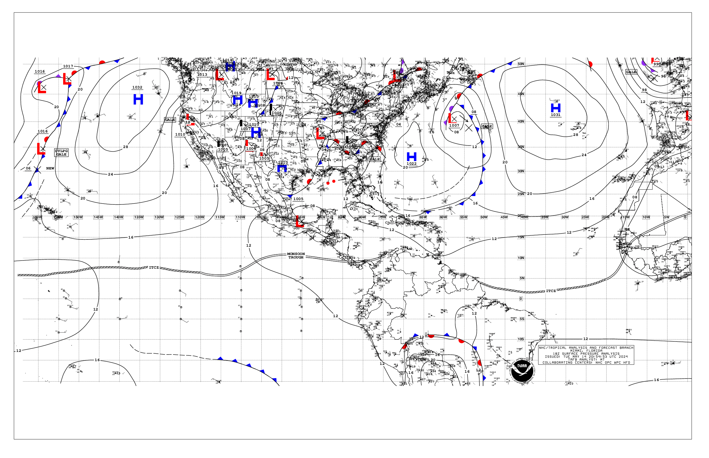
Based on 1800 UTC surface analysis and satellite imagery through
2000 UTC.
...SPECIAL FEATURES...
Eastern Atlantic Ocean Gale Warning: Pulsing gale-force winds are
forecast in the Agadir area of the Meteo-France high seas
forecast, specifically through 15/03 UTC, then again from 15/12
UTC to 16/00 UTC. Seas of 8-10 ft are possible with these winds.
Please read the latest High Seas Forecast is issued by Meteo-
France at https://wwmiws.wmo.int for more details.
...MONSOON TROUGH/ITCZ...
The monsoon trough passes through the coastal plains of Guinea-
Bissau near 11N15W to 04.5N20W. The ITCZ continues from 04.5N20W
to 01N40W to near the coast of Brazil near 04N51W. Scattered
moderate to isolated strong convection is noted from 01N to 08N
between 18W and 31W, and from 04N to 10N between 31W and 55W.
...GULF OF MEXICO...
A cold front in the NW Gulf from Louisiana to just S of the Rio
Grande has stalled this afternoon. Ahead of the front, a squall
line is moving through portions of the NE Gulf from offshore the
Florida Big Bend to south of the mouth of the Mississippi River.
A trough is southeast of the front, from 26N92W to 20N95W.
Moderate to fresh return flow is east of the trough per earlier
ASCAT scatterometer data, with moderate NW-N winds west of the
trough, locally fresh offshore Veracruz, Mexico. Seas are in the
4-7 ft range east of the trough, and in the 3-5 ft range west of
the trough.
For the forecast, thunderstorms with the squall line may lead to
locally stronger winds and rough seas, along with heavy rain.
Through winds, additional thunderstorms are possible as the front
remains nearly stationary over the northern Gulf of Mexico. Winds
may weaken somewhat during the upcoming weekend as the gradient
relaxes. Meanwhile, haze due to agricultural fires in Mexico will
continue across most of the western Gulf and Bay of Campeche.
...CARIBBEAN SEA...
A relatively tight pressure gradient is across the basin, with
fresh to strong winds in the NW Caribbean W of 85W, and in the
central Caribbean as sampled by a recent ASCAT scatterometer pass.
Moderate to fresh E-SE winds are elsewhere. Seas are in the 5-8 ft
range in the NW Caribbean W of 85W, in the 6-10 ft range in the
central Caribbean, and in the 3-6 ft range elsewhere. Deep
convection is noted in the SW Caribbean S of 11N near the monsoon
trough.
For the forecast, high pressure centered over the central
Atlantic will continue to support strong to near gale E to SE
winds near the Gulf of Honduras and fresh to strong winds in the
south-central basin into Sat night. Moderate to rough seas are
expected with the increasing winds. Gentle to moderate winds are
expected elsewhere through most of the week. Meanwhile, haze due
to agricultural fires in Central America will continue across some
areas of the northwestern Caribbean.
...ATLANTIC OCEAN...
Please refer to the Special Features section for details on a Gale
Warning in the East Atlantic Ocean.
A weak cold front extends from 31N51W to 24N54W, then dissipating
to near the Turks and Caicos Islands. Moderate to fresh southerly
winds and seas in the 5-7 ft range are N of 28N between the front
and 46W. High pressure at 1022 mb is centered W of Bermuda near
33N68W and is building in behind the front. Fresh to locally
strong southerly winds and seas in the 5-7 ft range are noted off
the NE Florida coast due to another approaching cold front. Gentle
to moderate winds and seas in the 3-5 ft range are elsewhere west
of the front. To the east of the front, high pressure dominates
the waters, except for a dissipating cold front from Morocco to
near the Canary Islands to 30N27W. Gentle to moderate trades
prevail across the open waters along with seas in the 4-7 ft seas,
except fresh to strong N of 17N between the coast of Africa and
22W.
For the forecast, the front will move E of the area tonight, with
high pressure building in its wake. As the front moves off the
Florida coast Thu, these fresh to strong winds will spread E. The
front will stall from near Bermuda to the central Bahamas Fri
night. Conditions around the front should improve by Fri, with
tranquil conditions then continuing through the upcoming weekend.
$$
Lewitsky


