832
AXPZ20 KNHC 132135
TWDEP
Tropical Weather Discussion
NWS National Hurricane Center Miami FL
2205 UTC Mon May 13 2024
Tropical Weather Discussion for the eastern Pacific Ocean from
03.4S to 30N, east of 120W including the Gulf of California, and
from the Equator to 30N, between 120W and 140W. The following
information is based on satellite imagery, weather observations,
radar, and meteorological analysis.
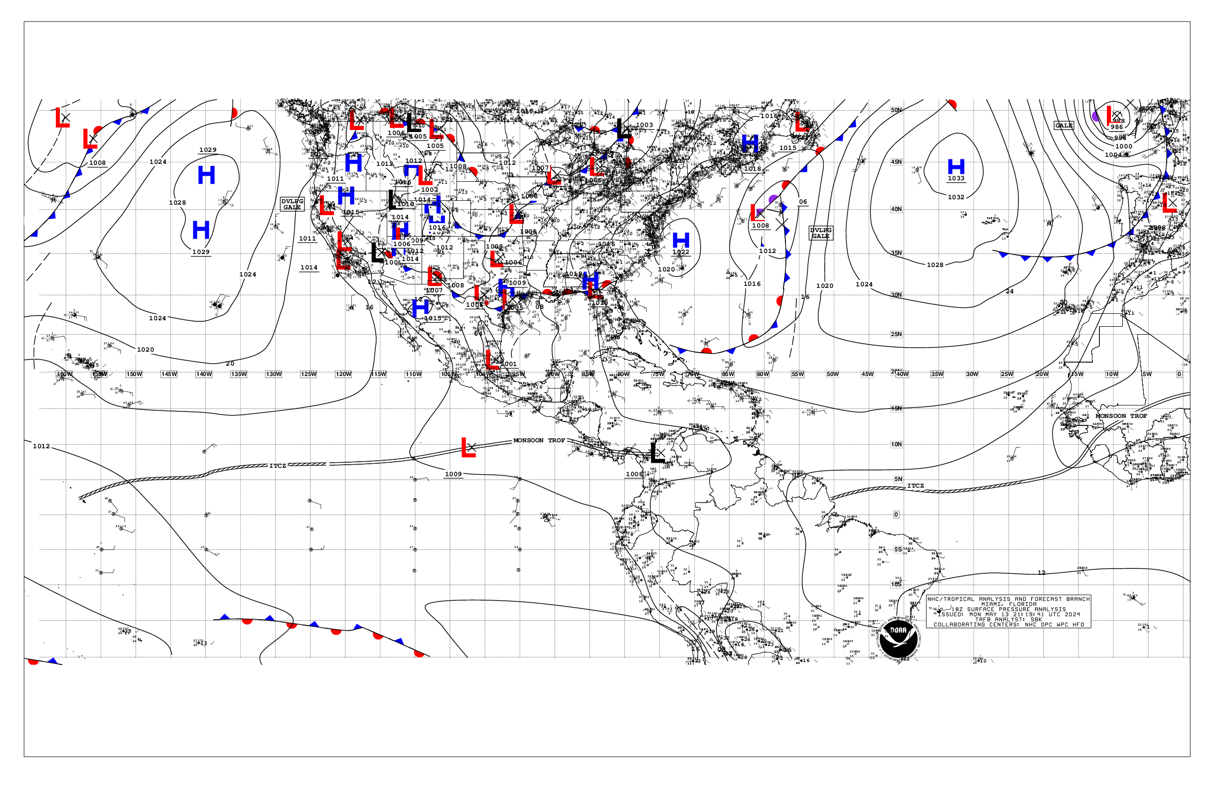
Based on 1800 UTC surface analysis and satellite imagery through
2105 UTC.
...INTERTROPICAL CONVERGENCE ZONE/MONSOON TROUGH...
The monsoon trough extends from the coast of NW Costa Rica near
10N86W to a 1009 mb low pres near 10N102W and to 07N123W. The
ITCZ stretches from 07N123W to beyond 06N140W. Scattered
moderate to isolated strong convection is present from 05N to
15N and east of 109W. Scattered moderate convection is noted
from 03N to 09N and west of 131W.
...OFFSHORE WATERS WITHIN 250 NM OF MEXICO...
A weak pressure pattern is found across the offshore waters of
Mexico. This weather pattern supports gentle to moderate
northerly winds over much of the offshore waters of Baja
California. Seas in these waters are 4-6 ft. Elsewhere, including
the Gulfs of California and Tehuantepec, light to gentle winds
and slight to moderate seas are prevalent.
For the forecast, gentle to moderate NW winds, pulsing to locally
fresh nightly, and moderate seas or less, will persist off the Baja
California waters through this week and into the upcoming weekend.
Pulsing off moderate to locally fresh gap winds will push through
the mountain passages of Baja California into the Gulf of California
at night through much of the week. Gentle to locally moderate
winds and moderate seas are expected elsewhere across the open
offshore waters of Mexico through late this week.
...OFFSHORE WATERS WITHIN 250 NM OF CENTRAL AMERICA, COLOMBIA,
AND WITHIN 750 NM OF ECUADOR...
Latest satellite imagery depict scattered showers and isolated
thunderstorms in the nearshore and offshore waters of Central
America and Colombia. Meanwhile, the persistent weak pressure
gradient maintains moderate or weaker winds and moderate seas
across the basin. However, gusty winds and higher seas are
possible with the strongest storms.
For the forecast, gentle to moderate southerly winds are
forecast south of the monsoon trough through the end of the
week. Southerly swell moving through the regional waters will
support seas of 5-7 ft south of the Galapagos Islands through the
forecast period. An area of low pressure is forecast to form
south of the Gulf of Tehuantepec by mid to late week and move
west-northwestward. This will increase the winds and seas in the
offshore waters of Guatemala and El Salvador toward the end of
the week and into the upcoming weekend.
...REMAINDER OF THE AREA...
A broad subtropical ridge positioned well north of the far NW
waters remains the most prominent feature in the remainder of the
area. A recent scatterometer satellite pass depict moderate to
fresh easterly trade winds from the ITCZ to 20N and west of 127W.
Seas in these waters are 6-8 ft. Elsewhere, moderate or weaker
winds and moderate seas are prevalent.
For the forecast, moderate to locally fresh trade winds and
moderate seas are expected in the trade wind zone N of the ITCZ
to near 20N and W of 120W through the forecast period. An area of
low pressure is forecast to form south of the Gulf of Tehuantepec
by mid to late week and move west-northwestward. This will
increase the winds and seas in the eastern part of the basin
toward the end of the week and into the upcoming weekend.
$$
Delgado